Well, we’re starting off with great weather for the weekend!
Looking at the bigger picture, the low pressure system that brought us the rain yesterday has slowed down over the Great Lakes, but thankfully has already passed us to bring us a surface high so that the rain stays away for a day or so.
What’s brewing going into Sunday is coming in from the Southwest. Two shortwaves will meet up around Texas and split ways. One, which is the one we’ll be looking at is heading across eastern Texas into the Mississippi Delta on Sunday afternoon into the evening. The shortwave itself is fairly weak with the development on the surface, however the driving force in the mid-levels provide the moisture. The rain will most likely hit the central Pinebelt and may dip into the southern Pinebelt if there is enough moisture closer to the surface.
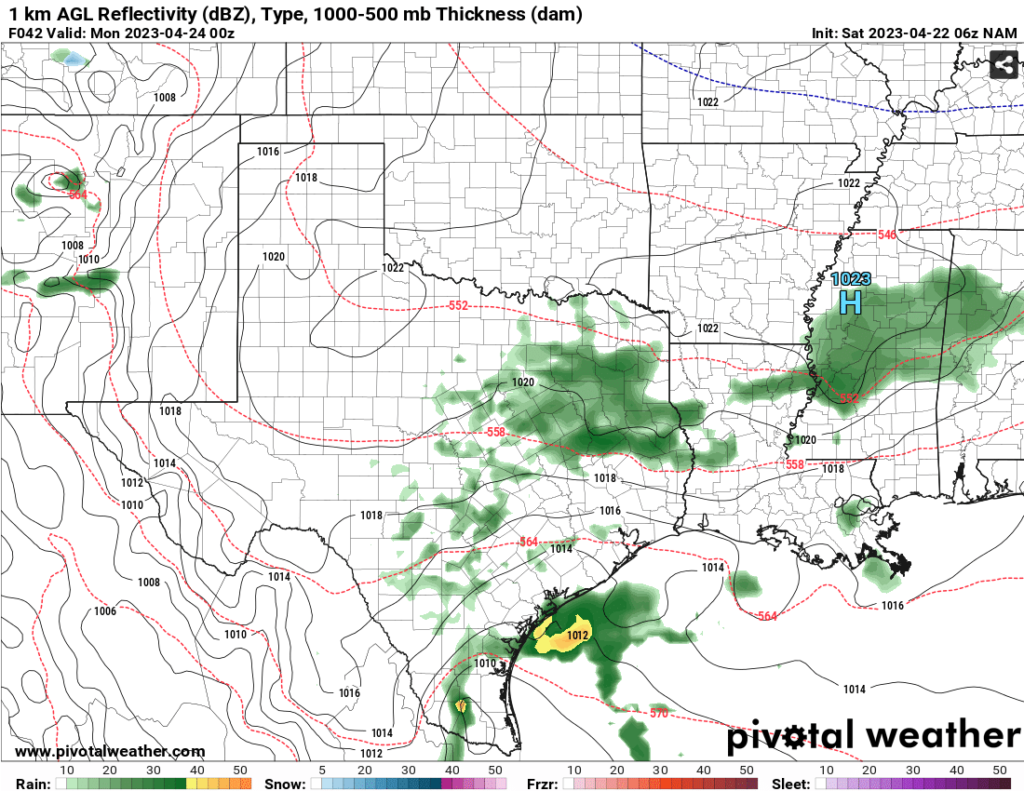
So far, the storms will arrive around the late evening around 5 pm into the overnight hours. Areas in the west to central Pinebelt will see the rain come in a little earlier as it moves east into our neck of the woods.

Regional Day-to-Day Forecast
Today – Sunny, with a high near 76. North northeast wind 5 to 10 mph, with gusts as high as 20 mph.
Tonight – Mostly clear, with a low around 51. Northeast wind around 5 mph becoming calm.
Sunday – Partly sunny, with a high near 76. North northeast wind 5 to 10 mph.
Sunday Night – Mostly cloudy, with a low around 54. North northeast wind 5 to 10 mph, with gusts as high as 20 mph.
Monday – Partly sunny, with a high near 73. Northeast wind 5 to 10 mph.
Monday Night – Partly cloudy, with a low around 54. East northeast wind around 5 mph.
Tuesday – A chance of showers, with thunderstorms also possible after 1pm. Partly sunny, with a high near 80. East wind 5 to 10 mph. Chance of precipitation is 30%.
Tuesday Night – Showers likely and possibly a thunderstorm. Mostly cloudy, with a low around 61. East wind around 5 mph. Chance of precipitation is 60%.
Wednesday – Showers likely and possibly a thunderstorm before 1pm, then a chance of showers and thunderstorms after 1pm. Partly sunny, with a high near 77. North northeast wind 5 to 10 mph, with gusts as high as 20 mph. Chance of precipitation is 60%.
Wednesday Night – A 20 percent chance of showers and thunderstorms. Mostly cloudy, with a low around 59.
Thursday – A 40 percent chance of showers and thunderstorms. Mostly cloudy, with a high near 76.
Thursday Night – A 30 percent chance of showers and thunderstorms. Mostly cloudy, with a low around 59.
Friday – A 20 percent chance of showers and thunderstorms. Mostly sunny, with a high near 79.
(adsbygoogle = window.adsbygoogle || []).push({});

