With both a subtropical system and a cold front hitting us during the first part of the weekend, Sunday will be a lot more pleasant with more seasonable type weather. Going into next week will be fairly pleasant until the end of the week when we’ll have another chance for some storms moving in.
The first part of the week, a strong surface high pressure ridge is moving in from the Northern plains to bring us some very pleasant temperatures and drier conditions for the middle of April. Temperatures will be right around average for this time of year and the clouds will be to a minimum for a few days.
From Tuesday into Wednesday, the winds will shift to the South as the Ridge moves eastward bringing more humid conditions as the dewpoints rise. While we know what this usually means for what the weather will bring, what is slightly uncertain is how fast the next system is going to move through the South.
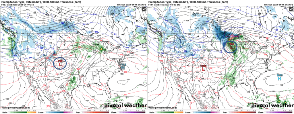

So far, the GFS and the European model disagree on the rate the shortwave low pressure system is moving through the Southeast. The GFS (above) shows two separate shortwaves developing one day after the other in the Rockies and moving northeast towards the Great Lakes. The European model calls for the first system to stay as one system. Where this causes problems, however, is how long we’ll see the rain. The Euro says that it will run through the South in one fell swoop from Thursday into Friday. Looking at the above graphics with the GFS, what could be possible with two systems developing one after the other is the possibility that these will latch onto each other and stall over the Southeast. The problem with the mid-to-upper levels is that there isn’t a lot of movement to push the trough forward, and there is a possibility that the system will stall over the Great Lakes over the weekend. Overall, this means that rain from Thursday into Saturday is possible.

So far, the SPC put the risk for severe weather towards Arkansas and Missouri. So far this looks to be a limited event, however this could change depending on how fast the shortwave moves through the mid-South. For the deep South, the storms seem to die down by the time they move past the Delta, however we’ll still see rain and thunderstorms as the front passes through.
Depending on the speed of the trough, this coming weekend could be fairly pleasant with the front moving out. Updates will be provided as the week goes on.
Regional Day-to-Day Forecast
Today – Mostly cloudy, then gradually becoming sunny, with a high near 71. Northwest wind around 15 mph, with gusts as high as 25 mph.
Tonight – Mostly clear, with a low around 44. Northwest wind 5 to 10 mph becoming light west northwest after midnight. Winds could gust as high as 20 mph.
Monday – Sunny, with a high near 74. Light northwest wind becoming north northwest 5 to 10 mph in the morning.
Monday NightClear, with a low around 48. North northwest wind around 5 mph becoming calm.
Tuesday – Sunny, with a high near 78. Light south southeast wind increasing to 5 to 10 mph in the morning.
Tuesday Night – Partly cloudy, with a low around 52. South wind around 5 mph.
Wednesday – Mostly sunny, with a high near 82. South southeast wind 5 to 10 mph, with gusts as high as 20 mph.
Wednesday Night – Partly cloudy, with a low around 61. South southeast wind around 5 mph becoming calm after midnight. Winds could gust as high as 20 mph.
Thursday – A 30 percent chance of showers and thunderstorms after 1pm. Mostly sunny, with a high near 85. South wind 5 to 10 mph, with gusts as high as 20 mph.
Thursday Night – A chance of showers and thunderstorms. Mostly cloudy, with a low around 65. Southeast wind at 5 to 10 mph. Chance of precipitation is 40%.
Friday – A 40 percent chance of showers and thunderstorms. Partly sunny, with a high near 82. South wind at 10 to 15 mph.
Friday Night – A 30 percent chance of showers. Mostly cloudy, with a low around 57. South southeast wind at 5 to 10 mph.
Saturday – Mostly sunny, with a high near 75. North wind at 5 to 10 mph.
(adsbygoogle = window.adsbygoogle || []).push({});

