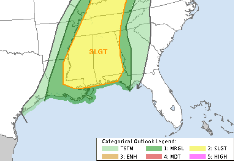
Here is a quick look at a county-by-county breakdown for the upcoming potential for severe weather on Thursday.
I’m still monitoring the potential for a “blob” of storms to help cut off some of the low-level flow ahead of the front, but – so far – that hasn’t shown up much in the higher-resolution short-range model guidance.
COUNTY-BY-COUNTY TIMELINE & THREATS
A quick reminder that this timeline is the first best estimate, based on the latest available data. There will be some changes during the coming 24 to 36 hours.
Louisiana
St. Helena Parish
Thursday 8a – 12p — Mostly cloudy with a stout southerly breeze. Isolated storms possible. Some severe. Main concern will be heavy rain, lightning wind gusts up to 60mph, hail up to the size of quarters, and a few tornadoes (up to EF-3 in strength).
Thursday 12p – Thursday 4p — Cold front passes with showers and storms ahead of and along the front. Some storms may be severe. Main concerns are brief heavy rain, lightning, wind gusts up to 70mph, small hail and a few tornadoes up to EF-2 in strength.
Thursday 4p – 7a — Storms ending, rain may continue, still breezy.
Tangipahoa Parish
Thursday 8a – 12p — Mostly cloudy with a stout southerly breeze. Isolated storms possible. Some severe. Main concern will be heavy rain, lightning wind gusts up to 60mph, hail up to the size of quarters, and a few tornadoes (up to EF-3 in strength).
Thursday 12p – Thursday 4p — Cold front passes with showers and storms ahead of and along the front. Some storms may be severe. Main concerns are brief heavy rain, lightning, wind gusts up to 70mph, small hail and a few tornadoes up to EF-2 in strength.
Thursday 4p – 7a — Storms ending, rain may continue, still breezy.
Livingston Parish
Thursday 8a – 12p — Mostly cloudy with a stout southerly breeze. Isolated storms possible. Some severe. Main concern will be heavy rain, lightning wind gusts up to 60mph, hail up to the size of quarters, and a few tornadoes (up to EF-3 in strength).
Thursday 12p – Thursday 4p — Cold front passes with showers and storms ahead of and along the front. Some storms may be severe. Main concerns are brief heavy rain, lightning, wind gusts up to 70mph, small hail and a few tornadoes up to EF-2 in strength.
Thursday 4p – 7a — Storms ending, rain may continue, still breezy.
Washington Parish
Thursday 9a – 1p — Mostly cloudy with a stout southerly breeze. Isolated storms possible. Some severe. Main concern will be heavy rain, lightning wind gusts up to 60mph, hail up to the size of quarters, and a few tornadoes (up to EF-3 in strength).
Thursday 1p – Thursday 5p — Cold front passes with showers and storms ahead of and along the front. Some storms may be severe. Main concerns are brief heavy rain, lightning, wind gusts up to 70mph, small hail and a few tornadoes up to EF-2 in strength.
Thursday 5p – 8a — Storms ending, rain may continue, still breezy.
St. Tammany Parish
Thursday 9a – 1p — Mostly cloudy with a stout southerly breeze. Isolated storms possible. Some severe. Main concern will be heavy rain, lightning wind gusts up to 60mph, hail up to the size of quarters, and a few tornadoes (up to EF-3 in strength).
Thursday 1p – Thursday 5p — Cold front passes with showers and storms ahead of and along the front. Some storms may be severe. Main concerns are brief heavy rain, lightning, wind gusts up to 70mph, small hail and a few tornadoes up to EF-2 in strength.
Thursday 5p – 8a — Storms ending, rain may continue, still breezy.
Mississippi
NEAR I-20
Copiah County
Thursday 8a – 12p — Mostly cloudy with a stout southerly breeze. Isolated storms possible. Some severe. Main concern will be heavy rain, lightning wind gusts up to 60mph, hail up to the size of quarters, and a few tornadoes (up to EF-3 in strength).
Thursday 12p – Thursday 4p — Cold front passes with showers and storms ahead of and along the front. Some storms may be severe. Main concerns are brief heavy rain, lightning, wind gusts up to 70mph, small hail and a few tornadoes up to EF-2 in strength.
Thursday 4p – 7a — Storms ending, rain may continue, still breezy.
Simpson County
Thursday 8a – 12p — Mostly cloudy with a stout southerly breeze. Isolated storms possible. Some severe. Main concern will be heavy rain, lightning wind gusts up to 60mph, hail up to the size of quarters, and a few tornadoes (up to EF-3 in strength).
Thursday 12p – Thursday 4p — Cold front passes with showers and storms ahead of and along the front. Some storms may be severe. Main concerns are brief heavy rain, lightning, wind gusts up to 70mph, small hail and a few tornadoes up to EF-2 in strength.
Thursday 4p – 7a — Storms ending, rain may continue, still breezy.
Smith County
Thursday 9a – 1p — Mostly cloudy with a stout southerly breeze. Isolated storms possible. Some severe. Main concern will be heavy rain, lightning wind gusts up to 60mph, hail up to the size of quarters, and a few tornadoes (up to EF-3 in strength).
Thursday 1p – Thursday 5p — Cold front passes with showers and storms ahead of and along the front. Some storms may be severe. Main concerns are brief heavy rain, lightning, wind gusts up to 70mph, small hail and a few tornadoes up to EF-2 in strength.
Thursday 5p – 8a — Storms ending, rain may continue, still breezy.
Scott County
Thursday 9a – 1p — Mostly cloudy with a stout southerly breeze. Isolated storms possible. Some severe. Main concern will be heavy rain, lightning wind gusts up to 60mph, hail up to the size of quarters, and a few tornadoes (up to EF-3 in strength).
Thursday 1p – Thursday 5p — Cold front passes with showers and storms ahead of and along the front. Some storms may be severe. Main concerns are brief heavy rain, lightning, wind gusts up to 70mph, small hail and a few tornadoes up to EF-2 in strength.
Thursday 5p – 8a — Storms ending, rain may continue, still breezy.
Jasper County
Thursday 9a – 1p — Mostly cloudy with a stout southerly breeze. Isolated storms possible. Some severe. Main concern will be heavy rain, lightning wind gusts up to 60mph, hail up to the size of quarters, and a few tornadoes (up to EF-3 in strength).
Thursday 1p – Thursday 5p — Cold front passes with showers and storms ahead of and along the front. Some storms may be severe. Main concerns are brief heavy rain, lightning, wind gusts up to 70mph, small hail and a few tornadoes up to EF-2 in strength.
Thursday 5p – 8a — Storms ending, rain may continue, still breezy.
Newton County
Thursday 9a – 1p — Mostly cloudy with a stout southerly breeze. Isolated storms possible. Some severe. Main concern will be heavy rain, lightning wind gusts up to 60mph, hail up to the size of quarters, and a few tornadoes (up to EF-3 in strength).
Thursday 1p – Thursday 5p — Cold front passes with showers and storms ahead of and along the front. Some storms may be severe. Main concerns are brief heavy rain, lightning, wind gusts up to 70mph, small hail and a few tornadoes up to EF-2 in strength.
Thursday 5p – 8a — Storms ending, rain may continue, still breezy.
Clarke County
Thursday 10a – 2p — Mostly cloudy with a stout southerly breeze. Isolated storms possible. Some severe. Main concern will be heavy rain, lightning wind gusts up to 60mph, hail up to the size of quarters, and a few tornadoes (up to EF-3 in strength).
Thursday 2p – Thursday 6p — Cold front passes with showers and storms ahead of and along the front. Some storms may be severe. Main concerns are brief heavy rain, lightning, wind gusts up to 70mph, small hail and a few tornadoes up to EF-2 in strength.
Thursday 6p – 9a — Storms ending, rain may continue, still breezy.
Lauderdale County
Thursday 10a – 2p — Mostly cloudy with a stout southerly breeze. Isolated storms possible. Some severe. Main concern will be heavy rain, lightning wind gusts up to 60mph, hail up to the size of quarters, and a few tornadoes (up to EF-3 in strength).
Thursday 2p – Thursday 6p — Cold front passes with showers and storms ahead of and along the front. Some storms may be severe. Main concerns are brief heavy rain, lightning, wind gusts up to 70mph, small hail and a few tornadoes up to EF-2 in strength.
Thursday 6p – 9a — Storms ending, rain may continue, still breezy.
HIGHWAY 84 CORRIDOR
Lincoln County
Thursday 8a – 12p — Mostly cloudy with a stout southerly breeze. Isolated storms possible. Some severe. Main concern will be heavy rain, lightning wind gusts up to 60mph, hail up to the size of quarters, and a few tornadoes (up to EF-3 in strength).
Thursday 12p – Thursday 4p — Cold front passes with showers and storms ahead of and along the front. Some storms may be severe. Main concerns are brief heavy rain, lightning, wind gusts up to 70mph, small hail and a few tornadoes up to EF-2 in strength.
Thursday 4p – 7a — Storms ending, rain may continue, still breezy.
Lawrence County
Thursday 8a – 12p — Mostly cloudy with a stout southerly breeze. Isolated storms possible. Some severe. Main concern will be heavy rain, lightning wind gusts up to 60mph, hail up to the size of quarters, and a few tornadoes (up to EF-3 in strength).
Thursday 12p – Thursday 4p — Cold front passes with showers and storms ahead of and along the front. Some storms may be severe. Main concerns are brief heavy rain, lightning, wind gusts up to 70mph, small hail and a few tornadoes up to EF-2 in strength.
Thursday 4p – 7a — Storms ending, rain may continue, still breezy.
Jeff Davis County
Thursday 9a – 1p — Mostly cloudy with a stout southerly breeze. Isolated storms possible. Some severe. Main concern will be heavy rain, lightning wind gusts up to 60mph, hail up to the size of quarters, and a few tornadoes (up to EF-3 in strength).
Thursday 1p – Thursday 5p — Cold front passes with showers and storms ahead of and along the front. Some storms may be severe. Main concerns are brief heavy rain, lightning, wind gusts up to 70mph, small hail and a few tornadoes up to EF-2 in strength.
Thursday 5p – 8a — Storms ending, rain may continue, still breezy.
Covington County
Thursday 9a – 1p — Mostly cloudy with a stout southerly breeze. Isolated storms possible. Some severe. Main concern will be heavy rain, lightning wind gusts up to 60mph, hail up to the size of quarters, and a few tornadoes (up to EF-3 in strength).
Thursday 1p – Thursday 5p — Cold front passes with showers and storms ahead of and along the front. Some storms may be severe. Main concerns are brief heavy rain, lightning, wind gusts up to 70mph, small hail and a few tornadoes up to EF-2 in strength.
Thursday 5p – 8a — Storms ending, rain may continue, still breezy.
Jones County
Thursday 9a – 1p — Mostly cloudy with a stout southerly breeze. Isolated storms possible. Some severe. Main concern will be heavy rain, lightning wind gusts up to 60mph, hail up to the size of quarters, and a few tornadoes (up to EF-3 in strength).
Thursday 1p – Thursday 5p — Cold front passes with showers and storms ahead of and along the front. Some storms may be severe. Main concerns are brief heavy rain, lightning, wind gusts up to 70mph, small hail and a few tornadoes up to EF-2 in strength.
Thursday 5p – 8a — Storms ending, rain may continue, still breezy.
Wayne County
Thursday 10a – 2p — Mostly cloudy with a stout southerly breeze. Isolated storms possible. Some severe. Main concern will be heavy rain, lightning wind gusts up to 60mph, hail up to the size of quarters, and a few tornadoes (up to EF-3 in strength)..
Thursday 2p – Thursday 6p — Cold front passes with showers and storms ahead of and along the front. Some storms may be severe. Main concerns are brief heavy rain, lightning, wind gusts up to 70mph, small hail and a few tornadoes up to EF-2 in strength.
Thursday 6p – 9a — Storms ending, rain may continue, still breezy.
HIGHWAY 98 CORRIDOR
Pike County
Thursday 8a – 12p — Mostly cloudy with a stout southerly breeze. Isolated storms possible. Some severe. Main concern will be heavy rain, lightning wind gusts up to 60mph, hail up to the size of quarters, and a few tornadoes (up to EF-3 in strength).
Thursday 12p – Thursday 4p — Cold front passes with showers and storms ahead of and along the front. Some storms may be severe. Main concerns are brief heavy rain, lightning, wind gusts up to 70mph, small hail and a few tornadoes up to EF-2 in strength.
Thursday 4p – 7a — Storms ending, rain may continue, still breezy.
Walthall County
Thursday 8a – 12p — Mostly cloudy with a stout southerly breeze. Isolated storms possible. Some severe. Main concern will be heavy rain, lightning wind gusts up to 60mph, hail up to the size of quarters, and a few tornadoes (up to EF-3 in strength).
Thursday 12p – Thursday 4p — Cold front passes with showers and storms ahead of and along the front. Some storms may be severe. Main concerns are brief heavy rain, lightning, wind gusts up to 70mph, small hail and a few tornadoes up to EF-2 in strength.
Thursday 4p – 7a — Storms ending, rain may continue, still breezy.
Marion County
Thursday 9a – 1p — Mostly cloudy with a stout southerly breeze. Isolated storms possible. Some severe. Main concern will be heavy rain, lightning wind gusts up to 60mph, hail up to the size of quarters, and a few tornadoes (up to EF-3 in strength).
Thursday 1p – Thursday 5p — Cold front passes with showers and storms ahead of and along the front. Some storms may be severe. Main concerns are brief heavy rain, lightning, wind gusts up to 70mph, small hail and a few tornadoes up to EF-2 in strength.
Thursday 5p – 8a — Storms ending, rain may continue, still breezy.
Lamar County
Thursday 9a – 1p — Mostly cloudy with a stout southerly breeze. Isolated storms possible. Some severe. Main concern will be heavy rain, lightning wind gusts up to 60mph, hail up to the size of quarters, and a few tornadoes (up to EF-3 in strength).
Thursday 1p – Thursday 5p — Cold front passes with showers and storms ahead of and along the front. Some storms may be severe. Main concerns are brief heavy rain, lightning, wind gusts up to 70mph, small hail and a few tornadoes up to EF-2 in strength.
Thursday 5p – 8a — Storms ending, rain may continue, still breezy.
Forrest County
Thursday 9a – 1p — Mostly cloudy with a stout southerly breeze. Isolated storms possible. Some severe. Main concern will be heavy rain, lightning wind gusts up to 60mph, hail up to the size of quarters, and a few tornadoes (up to EF-3 in strength).
Thursday 1p – Thursday 5p — Cold front passes with showers and storms ahead of and along the front. Some storms may be severe. Main concerns are brief heavy rain, lightning, wind gusts up to 70mph, small hail and a few tornadoes up to EF-2 in strength.
Thursday 5p – 8a — Storms ending, rain may continue, still breezy.
Perry County
Thursday 10a – 2p — Mostly cloudy with a stout southerly breeze. Isolated storms possible. Some severe. Main concern will be heavy rain, lightning wind gusts up to 60mph, hail up to the size of quarters, and a few tornadoes (up to EF-3 in strength).
Thursday 2p – Thursday 6p — Cold front passes with showers and storms ahead of and along the front. Some storms may be severe. Main concerns are brief heavy rain, lightning, wind gusts up to 70mph, small hail and a few tornadoes up to EF-2 in strength.
Thursday 6p – 9a — Storms ending, rain may continue, still breezy.
Greene County
Thursday 10a – 2p — Mostly cloudy with a stout southerly breeze. Isolated storms possible. Some severe. Main concern will be heavy rain, lightning wind gusts up to 60mph, hail up to the size of quarters, and a few tornadoes (up to EF-3 in strength).
Thursday 2p – Thursday 6p — Cold front passes with showers and storms ahead of and along the front. Some storms may be severe. Main concerns are brief heavy rain, lightning, wind gusts up to 70mph, small hail and a few tornadoes up to EF-2 in strength.
Thursday 6p – 9a — Storms ending, rain may continue, still breezy.
HIGHWAY 26 CORRIDOR
Pearl River County
Thursday 9a – 1p — Mostly cloudy with a stout southerly breeze. Isolated storms possible. Some severe. Main concern will be heavy rain, lightning wind gusts up to 60mph, hail up to the size of quarters, and a few tornadoes (up to EF-3 in strength).
Thursday 1p – Thursday 5p — Cold front passes with showers and storms ahead of and along the front. Some storms may be severe. Main concerns are brief heavy rain, lightning, wind gusts up to 70mph, small hail and a few tornadoes up to EF-2 in strength.
Thursday 5p – 8a — Storms ending, rain may continue, still breezy.
Stone County
Thursday 9a – 1p — Mostly cloudy with a stout southerly breeze. Isolated storms possible. Some severe. Main concern will be heavy rain, lightning wind gusts up to 60mph, hail up to the size of quarters, and a few tornadoes (up to EF-3 in strength).
Thursday 1p – Thursday 5p — Cold front passes with showers and storms ahead of and along the front. Some storms may be severe. Main concerns are brief heavy rain, lightning, wind gusts up to 70mph, small hail and a few tornadoes up to EF-2 in strength.
Thursday 5p – 8a — Storms ending, rain may continue, still breezy.
George County
Thursday 10a – 2p — Mostly cloudy with a stout southerly breeze. Isolated storms possible. Some severe. Main concern will be heavy rain, lightning wind gusts up to 60mph, hail up to the size of quarters, and a few tornadoes (up to EF-3 in strength).
Thursday 2p – Thursday 6p — Cold front passes with showers and storms ahead of and along the front. Some storms may be severe. Main concerns are brief heavy rain, lightning, wind gusts up to 70mph, small hail and a few tornadoes up to EF-2 in strength.
Thursday 6p – 9a — Storms ending, rain may continue, still breezy.
COASTAL MISSISSIPPI
Hancock County
Thursday 9a – 1p — Mostly cloudy with a stout southerly breeze. Isolated storms possible. Some severe. Main concern will be heavy rain, lightning wind gusts up to 60mph, hail up to the size of quarters, and a few tornadoes (up to EF-3 in strength).
Thursday 1p – Thursday 5p — Cold front passes with showers and storms ahead of and along the front. Some storms may be severe. Main concerns are brief heavy rain, lightning, wind gusts up to 70mph, small hail and a few tornadoes up to EF-2 in strength.
Thursday 5p – 8a — Storms ending, rain may continue, still breezy.
Harrison County
Thursday 9a – 1p — Mostly cloudy with a stout southerly breeze. Isolated storms possible. Some severe. Main concern will be heavy rain, lightning wind gusts up to 60mph, hail up to the size of quarters, and a few tornadoes (up to EF-3 in strength).
Thursday 1p – Thursday 5p — Cold front passes with showers and storms ahead of and along the front. Some storms may be severe. Main concerns are brief heavy rain, lightning, wind gusts up to 70mph, small hail and a few tornadoes up to EF-2 in strength.
Thursday 5p – 8a — Storms ending, rain may continue, still breezy.
Jackson County
Thursday 9a – 1p — Mostly cloudy with a stout southerly breeze. Isolated storms possible. Some severe. Main concern will be heavy rain, lightning wind gusts up to 60mph, hail up to the size of quarters, and a few tornadoes (up to EF-3 in strength).
Thursday 1p – Thursday 5p — Cold front passes with showers and storms ahead of and along the front. Some storms may be severe. Main concerns are brief heavy rain, lightning, wind gusts up to 70mph, small hail and a few tornadoes up to EF-2 in strength.
Thursday 5p – 8a — Storms ending, rain may continue, still breezy.
Alabama
Sumter County
Thursday 10a – 3p — Mostly cloudy with a stout southerly breeze. Isolated storms possible. Some severe. Main concern will be heavy rain, lightning wind gusts up to 60mph, hail up to the size of quarters, and a few tornadoes (up to EF-3 in strength).
Thursday 3p – Thursday 6p — Cold front passes with showers and storms ahead of and along the front. Some storms may be severe. Main concerns are brief heavy rain, lightning, wind gusts up to 70mph, small hail and a few tornadoes up to EF-2 in strength.
Thursday 6p – 8a — Storms ending, rain may continue, still breezy.
Choctaw County
Thursday 10a – 3p — Mostly cloudy with a stout southerly breeze. Isolated storms possible. Some severe. Main concern will be heavy rain, lightning wind gusts up to 60mph, hail up to the size of quarters, and a few tornadoes (up to EF-3 in strength).
Thursday 3p – Thursday 6p — Cold front passes with showers and storms ahead of and along the front. Some storms may be severe. Main concerns are brief heavy rain, lightning, wind gusts up to 70mph, small hail and a few tornadoes up to EF-2 in strength.
Thursday 6p – 8a — Storms ending, rain may continue, still breezy.
Washington County
Thursday 10a – 3p — Mostly cloudy with a stout southerly breeze. Isolated storms possible. Some severe. Main concern will be heavy rain, lightning wind gusts up to 60mph, hail up to the size of quarters, and a few tornadoes (up to EF-3 in strength).
Thursday 3p – Thursday 6p — Cold front passes with showers and storms ahead of and along the front. Some storms may be severe. Main concerns are brief heavy rain, lightning, wind gusts up to 70mph, small hail and a few tornadoes up to EF-2 in strength.
Thursday 6p – 8a — Storms ending, rain may continue, still breezy.
Mobile County
Thursday 9a – 18a — Mostly cloudy with a stout southerly breeze. Isolated storms possible. Some severe. Main concern will be heavy rain, lightning wind gusts up to 60mph, hail up to the size of quarters, and a few tornadoes (up to EF-3 in strength).
Thursday 18a – Thursday 7p — Cold front passes with showers and storms ahead of and along the front. Some storms may be severe. Main concerns are brief heavy rain, lightning, wind gusts up to 70mph, small hail and a few tornadoes up to EF-2 in strength.
Thursday 7p – 9a — Storms ending, rain may continue, still breezy.


