The cold front from last night has passed leaving us much cooler and windier than we’ve felt in the past few days. With a sharp trough moving in and a massive midwestern ridge taking precedent over the eastern US, we’ll stay in a cool, wintry-like pattern for most of the week. Temperatures will stay around the mid-50s to low 60s during the day and low 30s to low 40s at night. Frost will be likely for the first few nights of the week as temperatures will reach or get close to the freezing point.
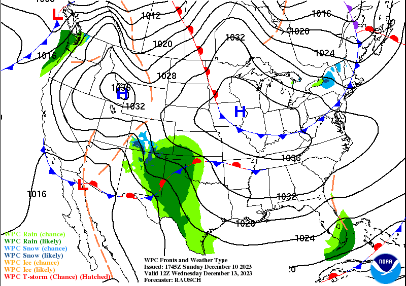
The high is fairly strong (over 1036 millibars) and will have an influence on any rain chances we’ll receive closer to the weekend. The Euro and GFS both show the low in Texas (pictured above) moving far south into the Gulf before possibly climbing up the eastern seaboard into next week. Depending on how low this shortwave wants to go, we may see some rain closer to the coastline around Louisiana, Mississippi, and Alabama. It does look possible that we could see some rain as the low will have plenty of moisture to work with, but it does depend on whether it rides the coastline or not.

With that, there is also a more southerly/easterly influence which will cause temperatures to rise a bit by the weekend as well. Temperatures will climb into the mid-60s and lows will reach the 40s. A mix of clouds with rain chances are possible across the coastline and slightly inland.
Have a good week!
[wpcode id=”41149″]
[wpcode id=”41179″]
[wpcode id=”41149″]
Regional Day-to-Day Forecast
Today – Sunny, with a high near 55. Northwest wind 5 to 10 mph, with gusts as high as 25 mph.
Tonight – Clear, with a low around 31. North northwest wind around 5 mph becoming calm in the evening. Winds could gust as high as 20 mph.
Monday – Widespread frost before sunrise. Otherwise, sunny, with a high near 56. North northeast wind around 5 mph becoming calm in the morning.
Monday Night – Widespread frost overnight. Otherwise, increasing clouds, with a low around 31. Calm wind.
Tuesday – Widespread frost in the early morning. Otherwise, mostly sunny, with a high near 59. Calm wind becoming east northeast around 5 mph in the morning.
Tuesday Night – Areas of frost overnight. Otherwise, partly cloudy, with a low around 34. Northeast wind around 5 mph.
Wednesday – Areas of frost in the early morning. Otherwise, partly sunny, with a high near 59. Northeast wind 5 to 10 mph, with gusts as high as 20 mph.
Wednesday Night – Mostly cloudy, with a low around 42. Northeast wind 5 to 10 mph, with gusts as high as 20 mph.
Thursday – Partly sunny, with a high near 60. East northeast wind around 10 mph, with gusts as high as 20 mph.
Thursday Night – Mostly cloudy, with a low around 43.
Friday – A 20 percent chance of showers. Partly sunny, with a high near 58.
Friday Night – A 40 percent chance of showers. Mostly cloudy, with a low around 47.
Saturday – A 40 percent chance of showers and thunderstorms. Mostly cloudy, with a high near 58.


