As we move through the day on Saturday and into Sunday, a pretty potent system is going to swing through the area bringing a chance for storms, the threat for a few stronger storms close to the coast, then some pretty stout cold, and the potential for some wintry precip.
On some of these counties you may see “up to XX” possible” and please know that “up to” means that nothing is also an option. In this case, the range of potentials includes zero accumulations. And in fact, zero accumulations is most likely in most places.
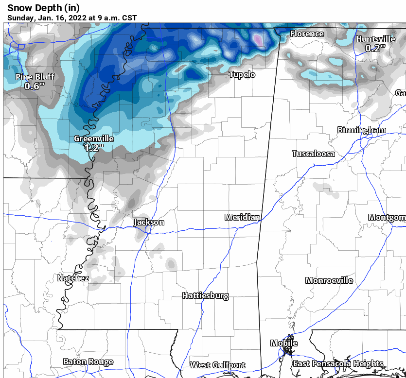
Do know, I’ll have another update posted tomorrow morning as the new model data comes in. But given the latest data, here is a county-by-county breakdown of the current weather forecast for rain, storms and wintry weather….
Louisiana
St. Helena Parish
Timeline: Sat 9a – 6p
Threats: Heavy rain, thunder, gusty wind
Snow: Unlikely
Coldest Temps Sunday: Mid 30s
Tangipahoa Parish
Timeline: Sat 9a – 6p
Threats: Heavy rain, thunder, gusty wind
Snow: Unlikely
Coldest Temps Sunday: Mid 30s
Washington Parish
Timeline: Sat 10a – 6p
Threats: Heavy rain, thunder, gusty wind
Snow: Unlikely
Coldest Temps Sunday: Mid 30s
Livingston Parish
Timeline: Sat 10a – 7p
Threats: Heavy rain, thunder, gusty wind
Snow: Unlikely
Coldest Temps Sunday: Mid 30s
St. Tammany Parish
Timeline: Sat 10a – 7p
Threats: Heavy rain, thunder, gusty wind
Snow: No accumulations expected
Coldest Temps Sunday: Mid 30s
Mississippi
NEAR I-20
Copiah County
Rain Timeline: Sat 10a – 7p
Threats: Heavy rain, thunder, gusty wind
Snow: Up to 1″ possible
Snow Timeline: Sun 1a – 9a
Coldest Temps Sunday: Mid 30s
Simpson County
Rain Timeline: Sat 10a – 7p
Threats: Heavy rain, thunder, gusty wind
Snow: Up to 1″ possible
Snow Timeline: Sun 1a – 9a
Coldest Temps Sunday: Mid 30s
Smith County
Rain Timeline: Sat 11a – 8p
Threats: Heavy rain, thunder, gusty wind
Snow: Up to 1/2″ possible
Snow Timeline: Sun 3a – 11a
Coldest Temps Sunday: Mid 30s
Jasper County
Rain Timeline: Sat 11a – 8p
Threats: Heavy rain, thunder, gusty wind
Snow: Up to 1/2″ possible
Snow Timeline: Sun 3a – 11a
Coldest Temps Sunday: Mid 30s
Clarke County
Rain Timeline: Sat 12p – 9p
Threats: Heavy rain, thunder, gusty wind
Snow: Up to 1/2″ possible
Snow Timeline: Sun 3a – 11a
Coldest Temps Sunday: Mid 30s
HIGHWAY 84 CORRIDOR
Lincoln County
Rain Timeline: Sat 10a – 7p
Threats: Heavy rain, thunder, gusty wind
Snow: Up to 1/2″ possible
Snow Timeline: Sun 2a – 7a
Coldest Temps Sunday: Mid 30s
Lawrence County
Rain Timeline: Sat 10a – 7p
Threats: Heavy rain, thunder, gusty wind
Snow: Up to 1/2″ possible
Snow Timeline: Sun 2a – 8a
Coldest Temps Sunday: Mid 30s
Jeff Davis County
Rain Timeline: Sat 10a – 7p
Threats: Heavy rain, thunder, gusty wind
Snow: Up to 1/4″ possible
Snow Timeline: Sun 3a – 8a
Coldest Temps Sunday: Mid 30s
Covington County
Rain Timeline: Sat 11a – 8p
Threats: Heavy rain, thunder, gusty wind
Snow: Up to 1/4″ possible
Snow Timeline: Sun 3a – 8a
Coldest Temps Sunday: Mid 30s
Jones County
Rain Timeline: Sat 11a – 8p
Threats: Heavy rain, thunder, small hail, gusty wind
Snow: Less than 1/4″ most places
Snow Timeline: Sun 3a – 8a
Coldest Temps Sunday: Mid 30s
Wayne County
Rain Timeline: Sat 12p – 9p
Threats: Heavy rain, thunder, small hail, gusty wind
Snow: Less than 1/4″ most places
Snow Timeline: Sun 3a – 8a
Coldest Temps Sunday: Mid 30s
HIGHWAY 98 CORRIDOR
Pike County
Rain Timeline: Sat 9a – 6p
Threats: Heavy rain, thunder, gusty wind
Snow: Accumulations unlikely
Snow Timeline: Sun 3a – 8a
Coldest Temps Sunday: Mid 30s
Walthall County
Rain Timeline: Sat 9a – 6p
Threats: Heavy rain, thunder, gusty wind
Snow: Accumulations unlikely
Snow Timeline: Sun 3a – 8a
Coldest Temps Sunday: Mid 30s
Marion County
Rain Timeline: Sat 10a – 7p
Threats: Heavy rain, thunder, gusty wind
Snow: Accumulations unlikely
Snow Timeline: Sun 3a – 9a
Coldest Temps Sunday: Mid 30s
Lamar County
Rain Timeline: Sat 10a – 8p
Threats: Heavy rain, thunder, gusty wind
Snow: Accumulations unlikely
Snow Timeline: Sun 3a – 9a
Coldest Temps Sunday: Mid 30s
Forrest County
Rain Timeline: Sat 11a – 8p
Threats: Heavy rain, thunder, gusty wind
Snow: Accumulations unlikely
Snow Timeline: Sun 3a – 10a
Coldest Temps Sunday: Mid 30s
Perry County
Rain Timeline: Sat 10a – 7p
Threats: Heavy rain, thunder, gusty wind
Snow: Unlikely
Coldest Temps Sunday: Upper 30s
Greene County
Rain Timeline: Sat 10a – 7p
Threats: Heavy rain, thunder, gusty wind
Snow: Unlikely
Coldest Temps Sunday: Upper 30s
HIGHWAY 26 CORRIDOR
Pearl River County
Rain Timeline: Sat 10a – 6p
Threats: Heavy rain, thunder, gusty wind
Snow: Unlikely
Coldest Temps Sunday: Upper 30s
Stone County
Rain Timeline: Sat 11a – 8p
Threats: Heavy rain, thunder, gusty wind, and a brief tornado can’t be ruled out
Snow: Unlikely
Coldest Temps Sunday: Upper 30s
George County
Rain Timeline: Sat 12p – 9p
Threats: Heavy rain, thunder, gusty wind, and a brief tornado can’t be ruled out
Snow: Unlikely
Coldest Temps Sunday: Upper 30s
COASTAL MISSISSIPPI
Jackson County
Rain Timeline: Sat 12p – 9p
Threats: Heavy rain, thunder, gusty wind, and a brief tornado can’t be ruled out
Snow: Unlikely
Coldest Temps Sunday: Upper 30s
Harrison County
Rain Timeline: Sat 12p – 9p
Threats: Heavy rain, thunder, gusty wind, and a brief tornado can’t be ruled out
Snow: Unlikely
Coldest Temps Sunday: Upper 30s
Hancock County
Rain Timeline: Sat 12p – 9p
Threats: Heavy rain, thunder, gusty wind, and a brief tornado can’t be ruled out
Snow: Unlikely
Coldest Temps Sunday: Upper 30s
Alabama
Sumter County
Rain Timeline: Sat 1p – 10p
Threats: Heavy rain, thunder, small hail, gusty wind
Snow: Less than 1/4″ most places
Snow Timeline: Sun 3a – 8a
Coldest Temps Sunday: Mid 30s
Choctaw County
Rain Timeline: Sat 1p – 10p
Threats: Heavy rain, thunder, small hail, gusty wind
Snow: Less than 1/4″ most places
Snow Timeline: Sun 3a – 8a
Coldest Temps Sunday: Mid 30s
Washington County
Rain Timeline: Sat 1p – 11p
Threats: Heavy rain, thunder, gusty wind
Snow: Unlikely
Coldest Temps Sunday: Upper30s


