Howdy!
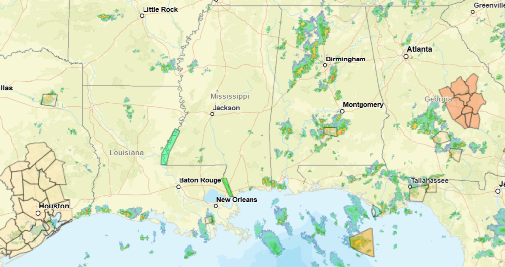
Looking out the window, we can see there are a good number of clouds over the region and scattered showers and thunderstorms. A storm out near Greenville, AL has a special weather statement as it is a strong thunderstorm producing wind gusts up to 40mph. We are already seeing some strong thunderstorms for the day.
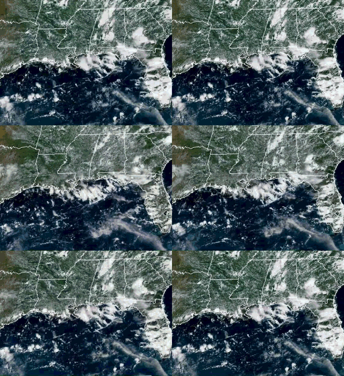
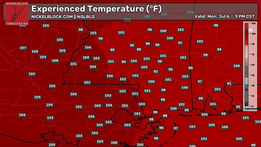
Today will be hot for much of the region, experienced temperatures reaching above 100 for a lot of the region, Louisiana getting the worst of it today.
The chance for showers and thunderstorms will be pretty widespread for the next couple of days, some of which can be strong and produce strong winds, heavy rain, and frequent lightning. This will be the general trend for the week, hot temperatures and afternoon showers and thunderstorms. This is a more typical summer pattern.
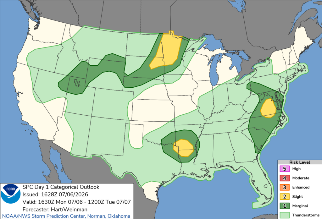
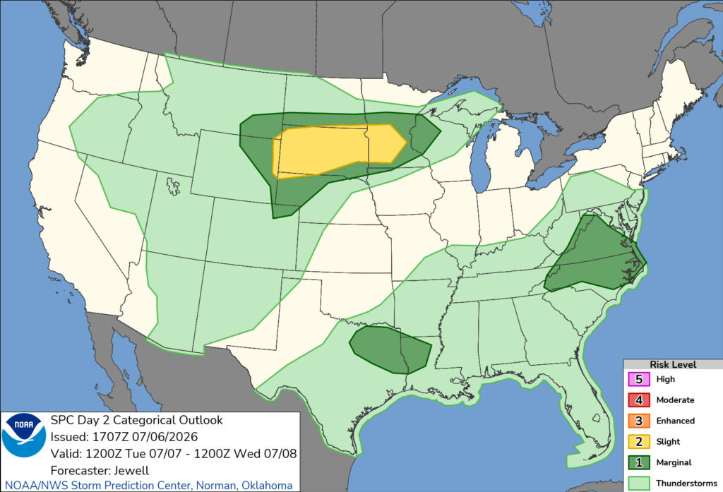
The SPC has put some parts of northern LA under a slight risk for severe weather today (left image below), main threats being winds. Most of the region falls under the general thunderstorm risk, but some could still be strong. In general, same trend for tomorrow (right image below), some portions of LA being under marginal risk for severe weather.
By the end of the week, a ridge will start to build up again over the region, keeping conditions hot and heat indices even hotter. This will allow for a more normal summer pattern of precipitation, as what we have been seeing recently has been slightly above normal.
3-DAY TRAVEL FORECAST
AIRPORTS
KIAH/KHOU (Houston) – No weather-related delays are anticipated. A slight chance for afternoon showers and thunderstorms exists today and tomorrow, but it is not expected to impact aviation.
KSHV (Shreveport) – Delays due to lightning are possible today and tomorrow afternoon. A slight chance for thunderstorms exists Wednesday, but no major impacts to aviation are expected.
KBTR (Baton Rouge) – Delays due to lightning are possible today and tomorrow afternoon. A slight chance for thunderstorms exists Wednesday, but no major impacts to aviation are expected.
KJAN (Jackson) – A slight chance for thunderstorms exists this afternoon, but no major impacts to aviation are expected. Brief delays due to lightning are possible tomorrow afternoon and Wednesday.
KMSY (New Orleans) – Brief delays due to lightning are possible today and tomorrow afternoon/evening. A slight chance for thunderstorms exists Wednesday, but no major impacts to aviation are expected.
KMOB (Mobile) – A chance for afternoon/evening showers and thunderstorms exists for each day, highest coverage on Tuesday. Brief delays are possible for Tuesday but not anticipated for today and Wednesday.
KATL (Atlanta) – A chance for afternoon/evening showers and thunderstorms exists for each day, highest coverage this afternoon. Brief delays are possible this afternoon due to lightning, but none are anticipated for tomorrow and Wednesday.
KTLH (Tallahassee) – Brief delays due to lightning are possible today and tomorrow afternoon/evening. A slight chance for thunderstorms exists Wednesday, but no major impacts to aviation are expected.
KBHM (Birmingham) – Brief delays due to lightning are possible this afternoon/evening. A slight chance for thunderstorms exists tomorrow and Wednesday, but no major impacts to aviation are expected.
HIGHWAYS
I-10 – Tonight, and overnight, some scattered showers and thunderstorms will form along I-10 in southern Louisiana and near the coast in Alabama. Tomorrow afternoon, heavy showers and some thunderstorms will impact the highway starting around 1pm, becoming heavy around 3-4pm, and continuing until around 9-10pm. Again, afternoon pop-up precipitation is possible for Wednesday, but not as significant or widespread.
I-20 – This evening (starting around 6pm), strong showers and thunderstorms will impact areas around I-20 in Louisiana and Mississippi. Early afternoon tomorrow will see showers and thunderstorms for Louisiana, continuing into the afternoon for MS and AL. Afternoon showers and thunderstorms for Wednesday are possible, mainly for AL and LA.
I-49 – This afternoon/evening, strong showers and thunderstorms will impact Louisiana, especially in the northern part of the state, strong winds and heavy rain are possible. Tomorrow, scattered showers and thunderstorms start to form in the early afternoon and continue into the evening for the state, and same trend for Wednesday, though not as widespread.
I-55 – Overnight tonight, some portions of central/northern MS will see some showers and thunderstorms, some of which could produce heavier rain. Tomorrow afternoon/evening, strong showers and thunderstorms will impact southern portions of MS and southeastern LA, clearing up by 10-11pm. Afternoon showers and thunderstorms are possible for Wednesday with not as widespread of coverage.
I-59 – Some scattered and isolated showers/thunderstorms possible this afternoon and tonight. Tomorrow morning and throughout the day, showers and thunderstorms are possible to impact regions of the highway in MS, continuing into AL in the evening. Wednesday, precipitation is possible to form along the highway in the afternoon, some scattered thunderstorms are possible.
I-65 – Scattered afternoon showers and thunderstorms are possible each day, especially in southern and central portions of Alabama. Some storms could produce heavy rainfall and some strong wind gusts. Less coverage for Wednesday, but today and tomorrow could see scattered to numerous showers and thunderstorms.
I-75 – Scattered showers and thunderstorms are possible each day, not as much coverage for Georgia. These next few days are good travel days for I-75, again the chance to see some thunderstorms are possible in the afternoon each day, so be cautious of this.
CITY FORECASTS
Houston, TX
Today/tonight – A 20% chance of showers and thunderstorms this afternoon, but other than that, it will be sunny with a high near 97. Heat index values could reach as high as 105, so it will be hot! Tonight, a 10% chance of showers and thunderstorms exists before 7pm. The low will reach around 80.
Tomorrow – A 20% chance of showers and thunderstorms in the afternoon, mainly between 1pm and 3pm. It will be sunny with a high near 97, and a low around 80. Heat index values as high as 105 for tomorrow, so again it will be hot.
Wednesday – Mostly sunny skies and a high in the upper 90s. The low will fall in the low 80s with mostly clear skies for Wednesday night.
Shreveport, LA
Today/tonight – This afternoon, a 40% chance of showers and thunderstorms exists. Today will be mostly sunny with a high near 93 and heat index values as high as 102. Tonight, chance for showers and thunderstorms increases to 50%, the low falling around 73.
Tomorrow – A 60% chance of showers and thunderstorms for the afternoon, a high of 91. The chance for precipitation continues tomorrow night before 7pm, with mostly cloudy skies and a low near 74.
Wednesday – A slight chance for showers and thunderstorms in the morning and afternoon. Mostly sunny skies with a high in the low 90s. The low will fall in the mid 70s and mostly clear skies for Wednesday night.
Baton Rouge, LA
Today/tonight – A 50% chance of showers and thunderstorms for today, a steady high temperature around 88. Higher rainfall amounts are expected in thunderstorms. The low tonight will be around 75, conditions gradually getting clear.
Tomorrow – 60% chance of showers and thunderstorms for the early afternoon, clouds increasing throughout the day and a high near 91. Tomorrow night, a 30% chance of showers and thunderstorms before 7pm, partly cloudy skies with a low around 75.
Wednesday – A slight chance of showers and thunderstorms in the afternoon, and a high in the lower 90s. The low will fall in the mid 70s with partly cloudy skies for Wednesday night.
Jackson, MS
Today/tonight – A 20% chance of showers and thunderstorms in the afternoon. Mostly sunny skies and a high near 91, heat index reaching as high as 102. Chance of precipitation continues tonight with partly cloudy skies and a low around 73.
Tomorrow – A 50% chance of showers and thunderstorms in the afternoon for tomorrow, besides that mostly sunny skies and a high near 90. Heat index values could reach as high as 101. Up to a quarter inch of rain is possible, higher amounts possible in thunderstorms. Showers continue tomorrow night, mostly cloudy then gradually becoming clear with a low around 73.
Wednesday – A 40% chance of showers and thunderstorms for the day, mostly sunny skies and a high in the low 90s. Mostly clear skies for Wednesday night and a low in the mid 70s.
New Orleans, LA
Today/tonight – A 50% chance of showers and thunderstorms for today, partly sunny skies and a high near 91. Less than a tenth of an inch of rain is expected. Before 8pm, a 20% chance of precipitation exists. Mostly clear skies for tonight, a low around 77.
Tomorrow – A 60% chance of showers and thunderstorms in the afternoon, mainly between 2pm and 5pm. Mostly sunny skies with a high near 90. Before 7pm, a 30% chance of showers and thunderstorms exists, and the low will fall around 77.
Wednesday – A 30% chance of showers and thunderstorms for the afternoon, mostly sunny skies and a high in the low 90s. The low will fall in the upper 70s, partly cloudy for Wednesday night.
Mobile, AL
Today/tonight – A 30% chance of showers and thunderstorms for today, mostly sunny and a high near 92. Tonight, a 20% chance of showers and thunderstorms mainly before 10pm, with a low around 75.
Tomorrow – A 40% chance of showers and thunderstorms for tomorrow afternoon. Besides that, mostly sunny and a high near 93. Heat index values could reach as high as 105. Tomorrow night, mostly clear skies with a low around 75.
Wednesday – A slight chance of showers and thunderstorms in the afternoon. Mostly sunny skies and a high in the low 90s. The low will fall in the mid 70s.
Atlanta, GA
Today/tonight – A 50% chance of showers and thunderstorms for today. Mostly sunny skies and a high near 91. The chance of precipitation continuing tonight mainly before 8pm, with a low around 74.
Tomorrow – A 20% chance of showers and thunderstorms in the afternoon, mostly sunny skies and a high near 92. Wind gusts up to 15 mph. A slight chance of precipitation tomorrow night with a low around 76.
Wednesday – A 20% chance of showers and thunderstorms in the afternoon. Sunny skies and a high in the mid 90s, wind gusts up to 15 mph. A slight chance of precipitation continues Wednesday night before 8pm, mostly clear skies and a low in the upper 70s.
Tallahassee, FL
Today/tonight – A 40% chance of showers and thunderstorms for today, partly sunny and a high near 93. Heat index values could reach as high as 103. Tonight, a 30% chance of showers and thunderstorms, a low falling to 76.
Tomorrow – A 50% chance of showers and thunderstorms throughout the day, a high near 94. Heat index values could reach as high as 106. Less than a tenth of an inch of rain is expected, more in thunderstorms are possible. The low will fall around 76.
Wednesday – A 30% chance of showers and thunderstorms in the afternoon. Other than that, sunny skies and hot conditions, the high falling in the mid 90s. The low will fall in the mid 70s, and a 30% chance of showers and thunderstorms exists for Wednesday night.
Birmingham, AL
Today/tonight – A 40% chance of showers and thunderstorms for today, mostly sunny skies and a high near 90. A slight chance of precipitation for tonight, partly cloudy skies and a low around 73.
Tomorrow – A 30% chance of showers and thunderstorms for tomorrow afternoon, mostly sunny skies and a high near 91. A slight chance of precipitation for tomorrow night, and a low around 73.
Wednesday – A 30% chance of showers and thunderstorms for tomorrow afternoon, mostly sunny skies and a high in the lower 90s. The low will fall in the mid 70s with mostly clear skies for Wednesday night.


