As we approach the middle of November, it looks like the cold November rain is making its way to us! A shortwave coming from eastern Mexico into the Gulf will bring a good bit of precipitation to much of the rain-parched Deep South and could help relieve our exceptional drought.

Both the 500mb and surface show the low pressure system moving east into Texas and Louisiana come Monday. Judging by the temperature gradient, this system will keep temperatures slightly cooler but won’t have a big variation in temperature.
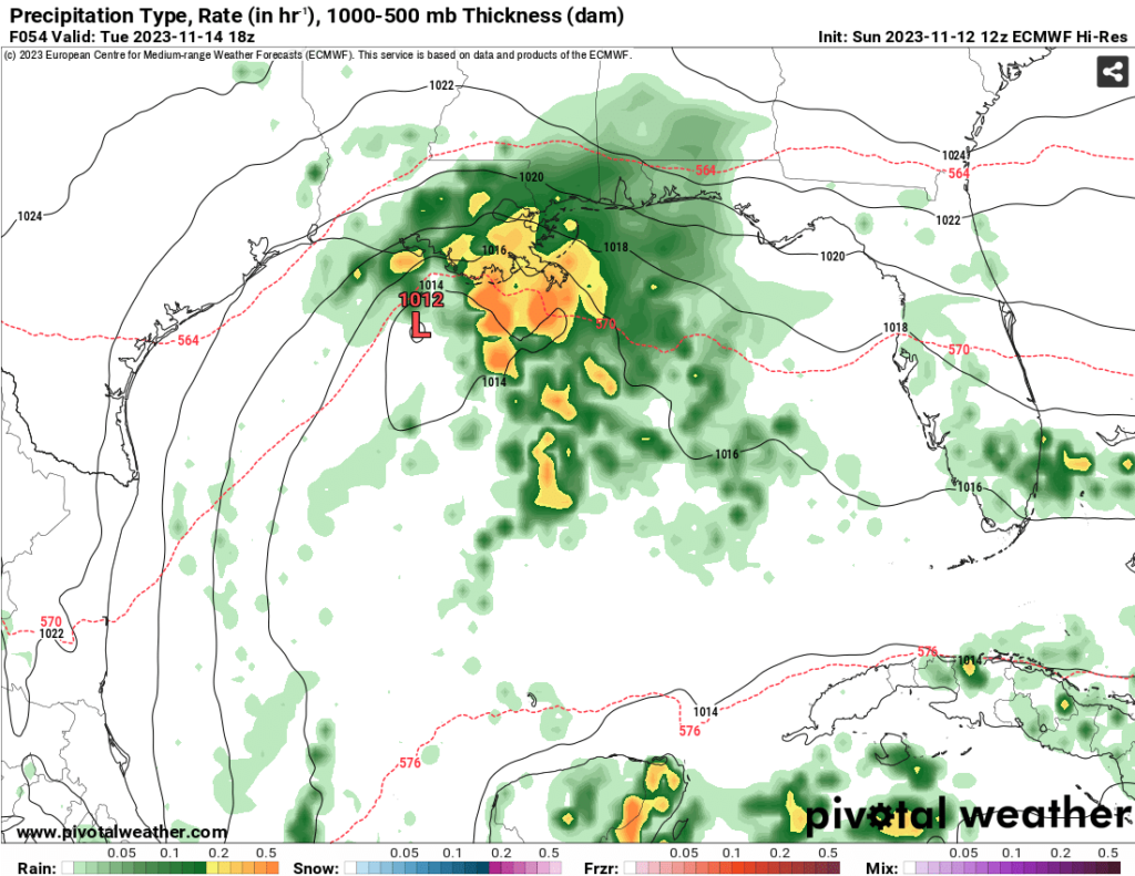
The main question is “when is this coming?” Both the Euro and GFS are showing the rain will likely move in around Monday evening. The system itself will ride along the coastline on Tuesday and Wednesday. By Thursday, the low will move further east towards Alabama and Georgia.

Since this system is riding the coastline, most of the rainfall will stay closer to the coast. However, most areas in the southern and central Pinebelt will see at least an inch of rain by the end of this. Areas on the southern end and around the coast will likely see 2 to 3 inches of rainfall. There aren’t any severe parameters to speak of, but we may likely see some heavier rainfall develop during those couple of days.
Temperatures will hover around the 50s to 60s until the rain leaves. Afterwards, temperatures will rise to the 70s as conditions dry up. This will remain for the weekend with partly cloudy skies.
[wpcode id=”41179″]
Regional Day-to-Day Forecast
This Afternoon – Mostly cloudy, with a high near 71. North northeast wind around 5 mph.
Tonight – A slight chance of drizzle in the morning. Cloudy, with a low around 55. Northeast wind around 5 mph.
Monday – A chance of showers in the afternoon. Patchy fog in the morning. Otherwise, mostly cloudy, with a high near 68. Northeast wind 5 to 10 mph. Chance of precipitation is 30%.
Monday Night – Showers likely, mainly after sunset. Cloudy, with a low around 54. East northeast wind around 5 mph. Chance of precipitation is 70%. New precipitation amounts between a quarter and half of an inch possible.
Tuesday – Showers. High near 62. East northeast wind around 10 mph, with gusts as high as 25 mph. Chance of precipitation is 90%. New precipitation amounts between 1 and 2 inches possible.
Tuesday Night – Showers and thunderstorms after midnight. Low around 54. East northeast wind around 10 mph, with gusts as high as 25 mph. Chance of precipitation is 90%. New rainfall amounts between three quarters and one inch possible.
Wednesday – Showers, mainly before sunrise. High near 65. East northeast wind around 10 mph, with gusts as high as 25 mph. Chance of precipitation is 80%.
Wednesday Night – A 30 percent chance of showers, mainly before midnight. Mostly cloudy, with a low around 55. East northeast wind around 10 mph, with gusts as high as 20 mph.
Thursday – A 20 percent chance of showers before sunrise. Mostly cloudy, with a high near 69. East northeast wind 5 to 10 mph, with gusts as high as 20 mph.
Thursday Night – Mostly cloudy, with a low around 56.
Friday – Mostly cloudy, with a high near 73.
Friday Night – Mostly cloudy, with a low around 54.
Saturday – Partly sunny, with a high near 72.
[wpcode id=”41149″]


