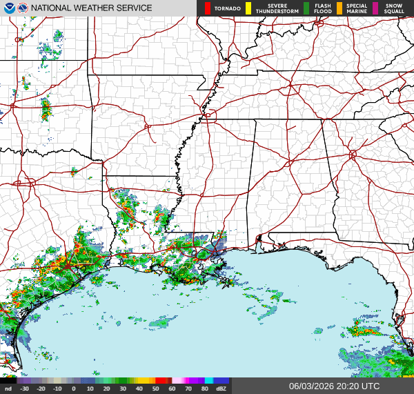
Current Conditions
Currently, we have showers and thunderstorms on the coast of TX and scattered in LA moving west. Some showers on the MS/LA border. Showers and thunderstorms in South FL that slowly move west. Mostly lingering.
Tonight
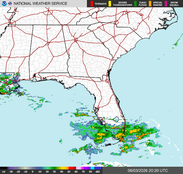
Now that the cold front has passed through, parts of the Southern region will feel drier. A relief from the warm, humid air we’ve been experiencing the past few weeks. Still seeing showers and thunderstorms throughout the region, especially in Southern LA and FL. These areas, along with parts of MS and TX are under a marginal risk for excessive rainfall tonight into tomorrow morning.


Scattered showers and thunderstorms will be moving west throughout the rest of today in South FL, LA, and parts of East TX. The precipitation can bring excessive rainfall in these areas. Make sure to stay updated for alerts. The concerns are heavy rain, lightning, and flash flooding. Then, some isolated showers in Southern MS and AL this evening, but not excessive rainfall.
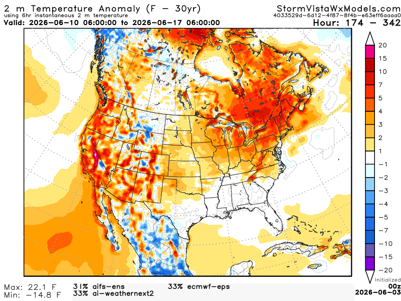
Extended Regional Outlook
The CPC outlook for the temperature has our region near normal, while the precipitation looks above normal for June 10th-16th.


Below is a blend of 3 models from 1 am CDT June 10th to 1 am CDT June 17th. For the Southern region, we don’t see any abnormal anomalies. We do see ridging on the West Coast and a trough in the Northern Plains, but the anomalies won’t affect the region. We could see our typical summer setup with warm temperatures and afternoon scattered showers and thunderstorms from the Gulf’s moisture. Seems the CPC and the extended regional outlook are similar!
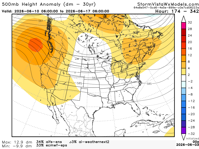
Below is a blend of the same 3 models showing us the surface temperatures. We see how the ridge on the West Coast is making the surface temperatures much warmer. Because of the trough in the Northern Plains, our region won’t be affected much at all by the extreme temperatures. The trough will bring southerly flow of moist air from the Gulf, which will maintain our temperatures near normal values.
Traveling Forecast (as of this afternoon)
KHOU – Houston: Thunderstorms with highs in the upper 80s. Currently 82°. Winds are NE 8 mph. Humidity is 72% with a dew point of 72°. Visibility is 10 miles. Chances for thunderstorms tonight. Low of 74°.
KSHV – Shreveport: Mostly cloudy with highs in the mid-80s. Currently 82°. Winds are E 10 mph. Humidity is 70% with a dew point of 72°. Visibility is 10 miles. Chances for thunderstorms and showers tonight. Low of 72°.
KBTR – Baton Rouge: Partly cloudy with highs in the lower 80s. Currently 85°. Winds are E 7 mph. Humidity is 65% with a dew point of 72°. Visibility is 10 miles. Chances for thunderstorms, then mostly cloudy tonight. Low of 69°.
KMSY – New Orleans: Mostly cloudy with highs in the lower 80s. Currently 83°. Winds are E 14 mph G 22 mph. Humidity is 74% with a dew point of 74°. Visibility is 10 miles. Thunderstorms are likely, and chance of showers tonight. Low of 75°.
KJAN – Jackson: Mostly cloudy with highs in the mid-80s. Currently 79°. Winds are SE 7 mph. Humidity is 79% with a dew point of 72°. Visibility is 10 miles. Mostly cloudy tonight. Low of 65°.
KBHM – Birmingham: Few clouds with highs in the lower 80s. Currently 77°. Winds are NE 13 mph G 18 mph. Humidity is 47% with a dew point of 55°. Visibility is 10 miles. Clear tonight. Low of 59°.
KMOB – Mobile: Mostly cloudy with highs in the lower 80s. Currently 80°. Winds are E 13 mph G 20 mph. Humidity is 67% with a dew point of 68°. Visibility is 10 miles. Mostly cloudy tonight. Low of 64°.
KATL – Atlanta: Few clouds with highs in the upper 70s. Currently 75°. Winds are E 8 mph. Humidity is 48% with a dew point of 54°. Visibility is 10 miles. Clear tonight. Low of 58°.
KTLH – Tallahassee: Partly cloudy with highs in the mid-80s. Currently 82°. Winds are E 13 mph G 22 mph. Humidity is 47% with a dew point of 60°. Visibility is 10 miles. Partly cloudy tonight. Low of 60°.
I-10: Clear stretching from FL to AL. Scattered showers and thunderstorms in TX in the afternoon into the late evening. Pop-ups during nighttime hours. Scattered showers and thunderstorms in LA during evening hours. Except showers and more organized thunders during the late evening into the nighttime hours in Southwest LA.
I-20: Clear stretching from SC to MS. Scattered showers and possible thunderstorms in LA during the evening into the nighttime hours. Possible isolated showers near the TX/LA border during the nighttime hours.
I-49: Showers and thunderstorms moving through LA during the evening and dissipating into the nighttime hours into showers. Isolated showers and possible thunderstorms near the LA/AR border during the nighttime hours.
I-55: Clear stretching from AR to MS. Scattered showers and thunderstorms in LA throughout today.
I-59: Clear stretching from AL and most of MS. Scattered showers and possible thunderstorms in LA throughout today. Isolated showers in Southern MS briefly during the late evening.
I-65: Clear stretching from TN and almost all of AL. Possible isolated showers in Southern AL briefly during the evening.
I-75: Clear stretching from TN to Northern FL. Scattered showers and thunderstorms in the Southern portion of FL until the nighttime hours. Turning into scattered showers in the late nighttime into the early morning hours.
3 Day City Forecast (as of this afternoon)
Houston, TX: Overcast. High of 86°. Thunderstorms likely. Tonight, mostly cloudy. Chances for thunderstorms. Low of 73°. Thursday, partly sunny. Chances for thunderstorms are increasing throughout the day. High of 84°. Thursday night, partly cloudy. Showers likely. Low of 74°. Friday, partly sunny. Chances for showers, then thunderstorms as the day progresses. High of 86°. Friday night, mostly cloudy. Low of 75°. Calm winds out of the East for the next 3 days.
Shreveport, LA: Few clouds. High of 87°. Slight chance of thunderstorms. Tonight, mostly cloudy. Chances for thunderstorms, then showers. Low of 72°. Thursday, partly sunny. Chances for thunderstorms, then showers. High of 84°. Thursday night, mostly cloudy. Slight chance of showers and thunderstorms. Low of 70°. Friday, mostly sunny. Slight chance for showers and thunderstorms. High of 88°. Friday night, mostly cloudy. Low of 72°. Winds up to 10 mph out of the Southeast for the next 3 days.
Baton Rouge, LA: Thunderstorms. High of 83°. Tonight, mostly cloudy. Chances for thunderstorms, then showers. Low of 71°. Thursday, partly sunny. Chances for thunderstorms. High of 82°. Thursday night, partly cloudy. Low of 69°. Friday, mostly sunny. Chances for showers, then thunderstorms. High of 84°. Friday night, mostly cloudy. Slight chance for showers and thunderstorms. Low of 73°. Winds up to 10 mph out of the East for the next 3 days.
New Orleans, LA: Overcast. Thunderstorms likely. High of 81°. Tonight, mostly cloudy, Showers and thunderstorms likely. Low of 76°. Thursday, partly sunny. Chance of showers and thunderstorms. High of 81°. Thursday night, partly cloudy. Chances of showers, possibly thunderstorms. Low of 74°. Friday, partly sunny. Chances of thunderstorms, then showers. High of 84°. Friday night, mostly cloudy. Chances of showers and thunderstorms. Low of 75°. Breezy. Up to 25 mph out of the east the next 3 days.
Jackson, MS: Mostly cloudy. High of 84°. Tonight, mostly cloudy. Low of 67°. Thursday, mostly sunny. High of 85°. Thursday night, partly cloudy. Low of 63°. Friday, mostly sunny. High of 87°. Friday night, mostly cloudy/ Low of 69°. Winds up to 10 mph out of the east-southeast.
Birmingham, AL: Few clouds. High of 81°. Tonight, clear. Low of 59°. Thursday, sunny. High of 82°. Thursday night, mostly clear. Low of 61°. Friday, sunny. High of 84°. Friday night, mostly clear. Low of 64°. Mostly calm winds out of the east. Could be up to 10 mph.
Mobile, AL: Overcast. High of 83°. Tonight, mostly cloudy. Low of 68°. Thursday, partly sunny. High of 84°. Thursday night, mostly cloudy. Low of 69°. Friday, mostly cloudy. Chance of showers, then thunderstorms. High of 85°. Friday night, mostly cloudy. Chance of showers. Low of 73°. Winds around 20 mph out of the East. Gusts Friday up to 20 mph.
Atlanta, GA: Clear. High of 78°. Tonight, clear. Low of 57°. Thursday, sunny. High of 82°. Thursday night, mostly clear. Low of 61°. Friday, mostly sunny. High of 84°. Friday night, mostly clear. Low of 64°. Mostly calm winds out of the east. Today, winds up to 15 mph.
Tallahassee, FL: Mostly sunny. High of 84°. Tonight, partly cloudy. Low of 61°. Thursday, mostly sunny. High of 86°. Thursday night, partly cloudy. Low of 65°. Friday, mostly sunny. High of 88°. Friday night, partly cloudy. Low of 68°. Winds up to 10 mph out of the east the next 3 days.


