As of 7 pm, Bertha earned her name as a tropical storm with sustained winds of 40 mph.
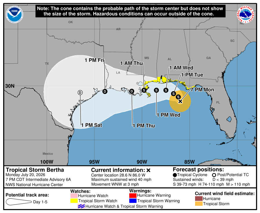
Tropical Storm Bertha is forecast to slowly meander west-northwest over the next few days. And based on the current track, impacts will generally be limited to coastal counties.
Be careful if traveling this week along I-10, as well as southern portions of I-49, I-55, and I-65!
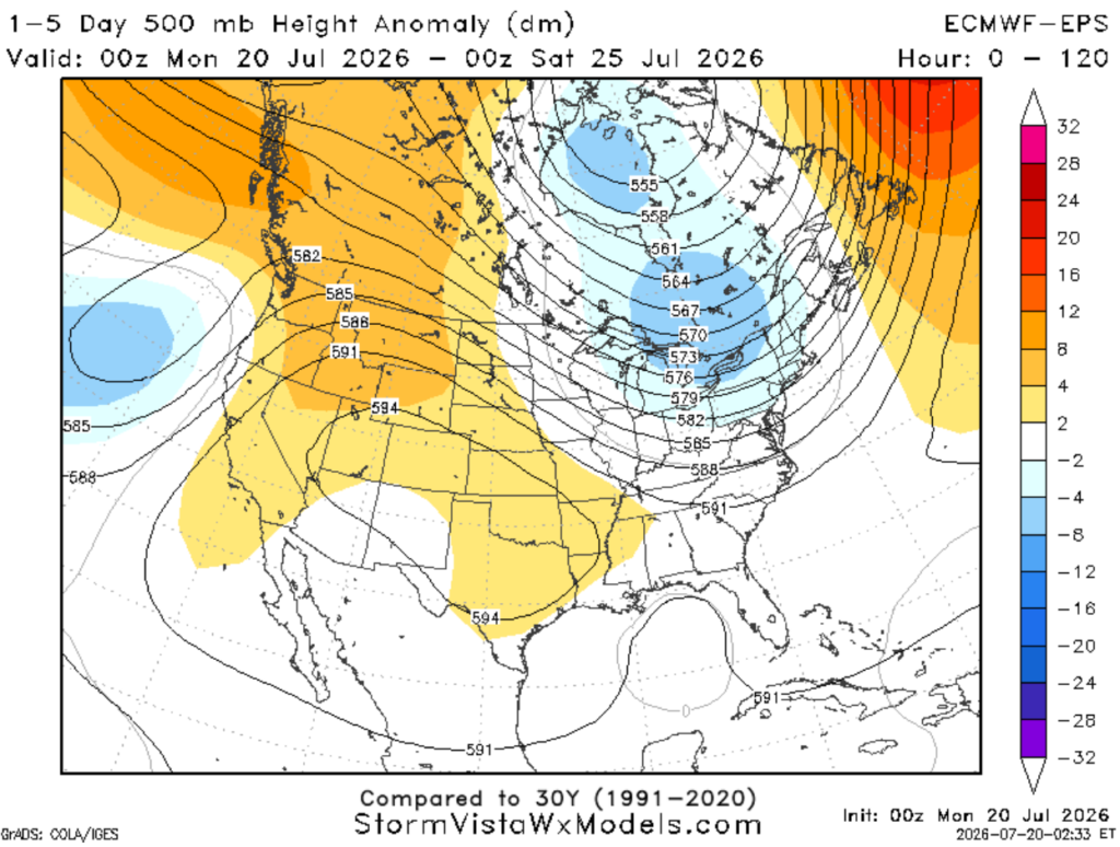
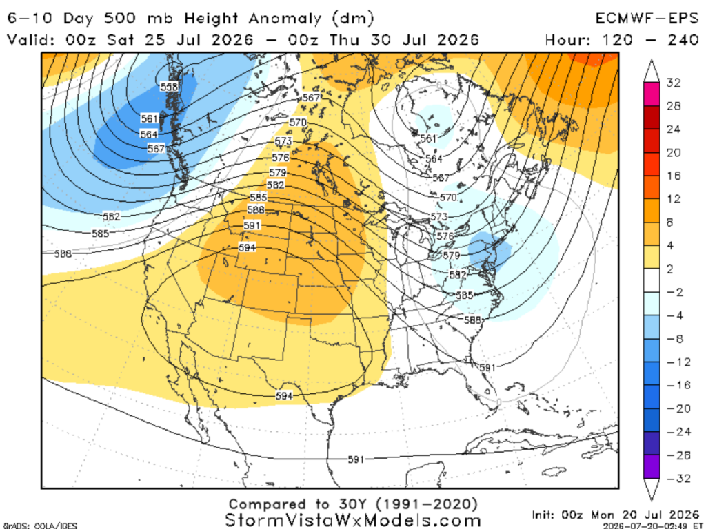
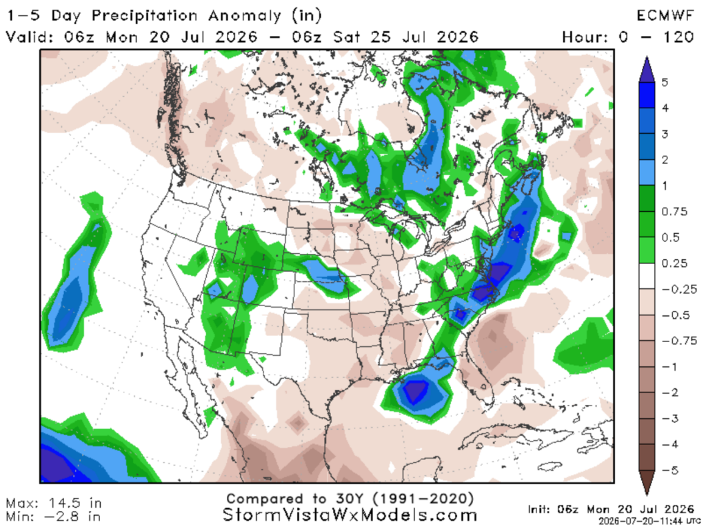
An upper high over the central Plains is building east (shown above). This means strong wind shear will remain over Bertha, keeping the bulk of the rainfall offshore (shown below).
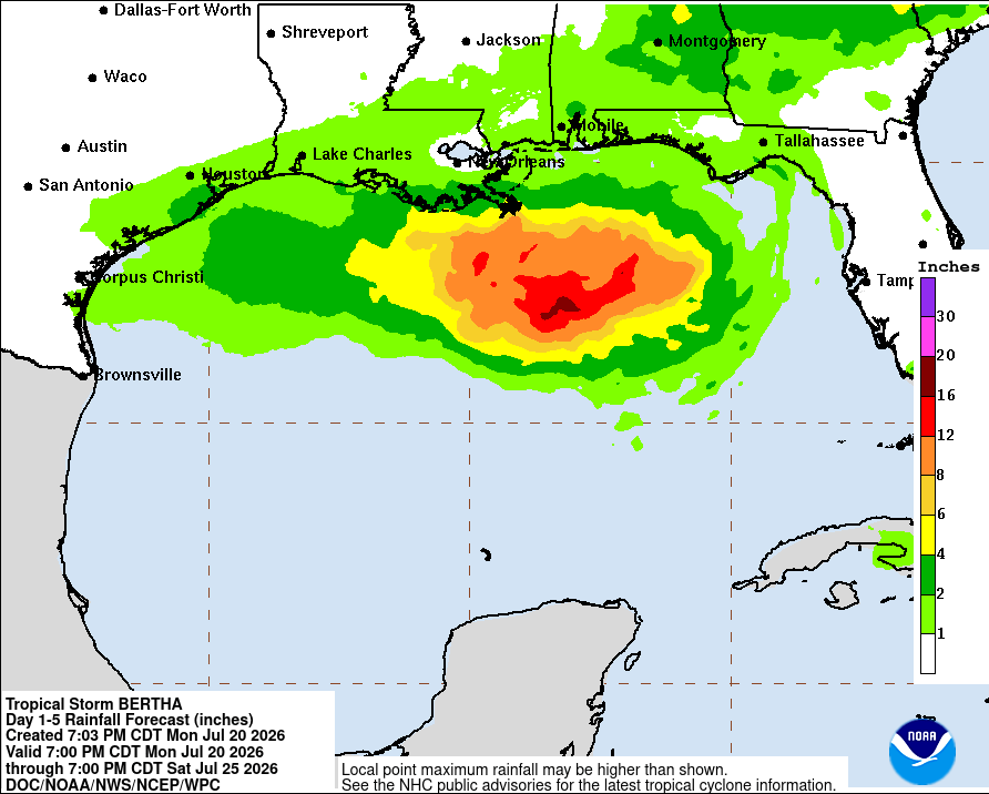
Bertha is expected to produce rainfall amounts of 2 to 4 inches through Friday along the Gulf Coast, including southern portions of Alabama, Mississippi, and Louisiana. Rainbands may produce areas of flash flooding, strong winds, and brief tornadoes.
However, any further northward shifts in Bertha’s track could increase rainfall amounts along the coast and farther inland, so check back in frequently!
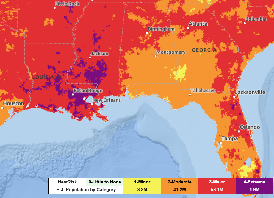
And if that wasn’t enough, the combination of heat and moist air (likely from Bertha) will result in moderate to extreme heat risk Tuesday and Wednesday.
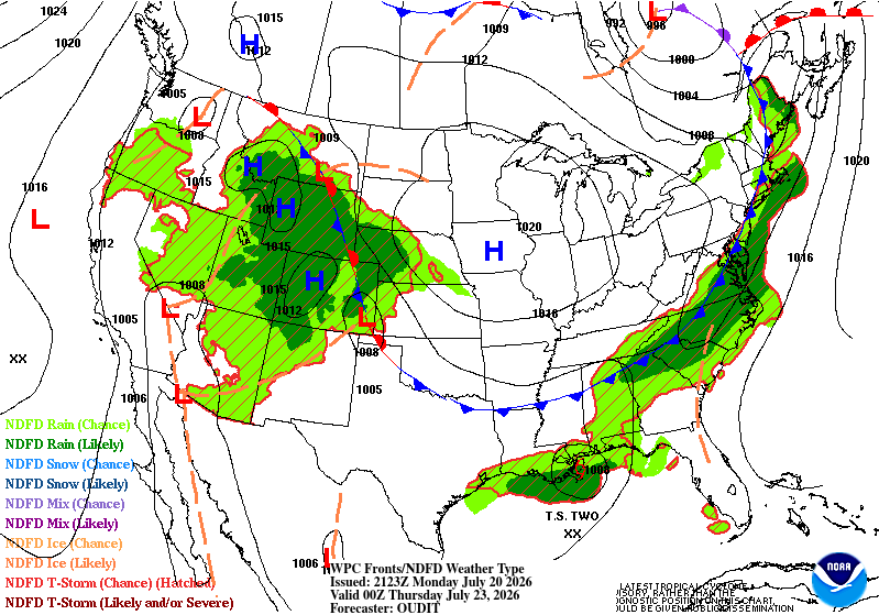
Looking ahead, a cold front could bring rainier and more active weather for our friends in the northern portions of Georgia and Mississippi later this week.
3-DAY TRAVEL FORECAST
AIRPORTS
KIAH / KHOU (Houston) –Hot! Aside from that, no weather-related issues anticipated through Wednesday.
KSHV (Shreveport) – Hot! Aside from that, no weather-related issues anticipated through Wednesday.
KBTR (Baton Rouge) – Afternoon showers and storms possible each day. Some intermittent flight delays are possible for lightning.
KMSY (New Orleans) – Scattered showers and thunderstorms through Wednesday. Impacts include heavy rain, gusty winds, and a brief tornado with any stronger rainbands that move through the region. Flight delays are possible each day for lightning and gusty winds.
KJAN (Jackson) – Hot! Aside from that, no weather-related issues anticipated through Wednesday.
KMOB (Mobile) – Scattered showers and thunderstorms each day. Impacts include heavy rain and gusty wind with any stronger rainbands that move through the region. Flight delays are possible each day for lightning and gusty winds.
KBMH (Birmingham) – Hot and a stray afternoon storm is possible. Aside from that, no weather-related issues anticipated through the Wednesday.
KTLH (Tallahassee) – Outer rainbands will continue over the next two days, posing a threat for strong winds, heavy rain, and the potential for brief tornadoes. Flight delays are possible each day for lightning and strong winds.
KATL (Atlanta) – Dry and quiet weather today and tomorrow. This changes Wednesday, where showers and thunderstorms could fire off in the afternoon and continue overnight. Some intermittent flight delays are possible for lightning.
HIGHWAYS
I-10
Scattered showers and thunderstorms each day, limited to coastal areas between New Orleans and Tallahassee. Impacts include heavy rain and gusty winds with any stronger rainbands that move through the region. Visibility can be limited at times due to heavy downpours. Watch for water on the roadways,
Dry and hot weather west of Louisiana.
I-20
Looking good through the next three days. No widespread major concerns anticipated. A spotty afternoon shower or storm can’t be ruled out.
I-49
Mostly dry over the next three days. However, Wednesday night we could see some outer rain bands from Bertha reach Lafayette.
I-55 & I-59
Hot and dry in northern portions near Jackson. Better shot at rain as you drive south toward the coast. Watch for flooded roadways, bands of heavy rain, and gusty winds near New Orleans.
I-65
Hot and dry in northern portions of I-65 near Birmingham. Better shot at rain as you drive south toward the coast. Watch for flooded roadways, bands of heavy rain, and gusty winds near Mobile as Bertha passes by.
I-75
Looks pretty dry for northern portions of I-75 near Atlanta. Some pop-up storms are possible each afternoon.
As you drive south of Macon, you could run into heavier bands of rain with gusty winds. If caught in one of these storms, drive slowly and use extra caution.
CITY FORECASTS
Houston, TX
Tonight – Mostly clear, with a low around 75. Calm winds.
Tuesday – Heat advisory in effect. Very hot and humid. Highs in the upper 90s, with heat index values around 108. Plenty of sunshine. Light breeze from the west.
Wednesday – Even hotter conditions and oppressive heat. Sunny skies, with highs near 102. Heat index values as high as 110. West wind continues.
Shreveport, LA
Tonight – Mostly clear, with a low around 80. Calm wind.
Tuesday – Heat advisory in effect for a daily high of 101 and “feels like” temperatures up to 110 degrees. Plenty of sunshine with a light breeze from the north. Cannot rule out a stray storm in the late afternoon.
Wednesday – Another scorcher! Sunny and extremely hot, with a high near 101, will feel closer to 112. Light breeze from the northwest 5-10mph.
Baton Rouge, LA
Tonight – Warm night with clear skies. Low of 79. Light breeze from the northwest.
Tuesday –Heat advisory in effect for “feels like” temperatures up to 113 degrees. Hot and sunny for most of the day, but scattered showers and thunderstorms could pop up in the late afternoon/evening. Light breeze from the north. Rain chance: 50%
Wednesday – Very humid with plenty of sunshine. Temperatures soaring to 99 degrees but could feel closer to 114. An isolated shower or thunderstorm could pop up in the late afternoon. Rain chance: 40%
New Orleans, LA
Tonight – Low-end chance of showers and thunderstorms, mainly before 10pm. Mostly clear, with a low around 82. Light breeze from the northwest.
Tuesday – Heat advisory in effect for “feels like” temperatures up to 110 degrees. Hot and dry for most of the day, but bands of heavy rain, and gusty wind could pop up in the evening. Light breeze from the north at 5-10mph. Rain chance: 40%
Wednesday – Bands of showers and thunderstorms possible. There is potential for storm surge 2-4 feet above ground somewhere within surge prone areas. Otherwise, partly sunny and hot, with a high near 95, will feel like 112. Rain chance: 50%
Jackson, MS
Tonight – Warm night with mostly clear skies. Low of 77 and calm wind.
Tuesday – Extreme heat warning in effect. Humid and “feels like” temperatures up to 115 degrees are possible. Plenty of sunshine with a light breeze from the north. Cannot rule out a stray storm. Drink water!
Wednesday – Heat continues with the daily highs easily approaching triple digits. Sunny and breezy with wind gusts up to 20mph possible. Cannot rule out a stray storm. Drink water!
Birmingham, AL
Tonight – Partly cloudy, with a low around 75. Calm wind.
Tuesday – Heat advisory in effect. Temperatures climbing to 95 combined with humid conditions will produce heat index values near 105. Plenty of sunshine with calm winds.
Wednesday – A mix of clouds and sun. Showers and storms may pop-up, increasing in coverage overnight. High near 93, will feel closer to 105. Light breeze from the south at 5-10mph. Rain chance: 30%
Mobile, AL
Tonight – Storms will move out of the area as sunset approaches. Then becoming mostly clear, with a low of 77. Northeast wind around 5 mph.
Tuesday – Sunny and hot with a high near 95, could feel like 107. Showers and thunderstorms possible after 1pm, continuing overnight. Northeast wind 10 to 15 mph, with gusts up to 20 mph. Rain chance: 50%
Wednesday – Storm surge heights potentially reaching 2-4 feet during periods of high tide for coastal areas. Very humid and hot. Rain bands with heavy rain and strong winds possible. Otherwise, partly sunny, with a high near 95, will feel closer to 110. Northeast wind around 15 mph, gusts as high as 20 mph. Rain chance: 60%
Tallahassee, FL
Tonight – Expect on/off storms as the outer rainbands of Tropical Storm Bertha move over the area tonight. Main threats are pockets of strong wind, heavy rain, and a brief, weak tornado. Low in the mid 70s. Winds roaring from the southeast at 10mph, gusts up to 20mph possible. Rain chance: 80%
Tuesday – Bands of rain will continue bringing the threat of strong winds (gusts up to 40mph), heavy rain, and a brief tornado. High near 87, will feel closer to 101. Rain chance: 90%
Wednesday –Windy and mostly sunny, with a high near 90, could feel closer to 103. South wind 10-20 mph, with gusts as high as 30 mph. Showers and thunderstorms possible. Rain chance: 40%
Atlanta, GA
Tonight – Lingering storms possible tonight before giving way to partly cloudy skies. Temperatures dropping down to 75. Light breeze from the south. Rain chance: 20%
Tuesday – Mostly sunny and hot with highs in the 90s and heat indices at 105. Southerly winds at 5-10mph, gusts up to 15mph. Can’t rule out a stray storm in the afternoon. Rain chance: 15%
Wednesday – One final day of heat indices exceeding 100, high near 92. Showers likely and possibly a thunderstorm, mainly after 2pm. A bit breezy with winds from the southwest at 5-10mph, gusts up to 15mph. Rain chance: 60%


