Grab an ice cream cone and stay hydrated this weekend, as heat indices will climb above 100F. The hot, mostly dry weather will give way to a much wetter pattern beginning late Sunday as a slow-moving front moves in. Multiple rounds of showers and thunderstorms are expected through midweek, with heavy rainfall potentially leading to flash flooding.

TONIGHT
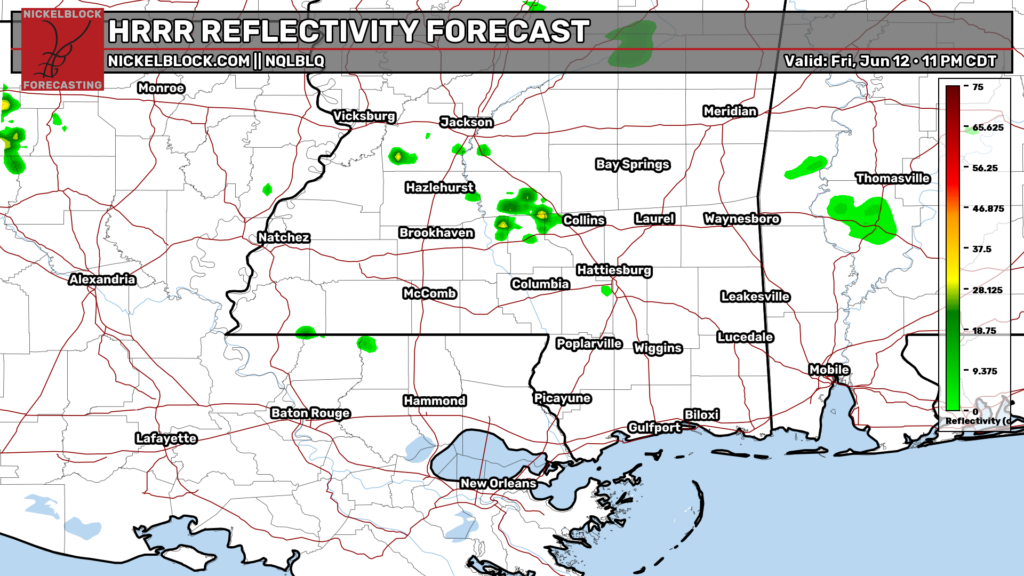
For the rest of tonight, remnants from earlier storms in northern Mississippi are likely to clear out in the next hour or so. Early summer kind of night with temps in the mid 70s, light wind from the south, and mostly clear skies.
TOMORROW
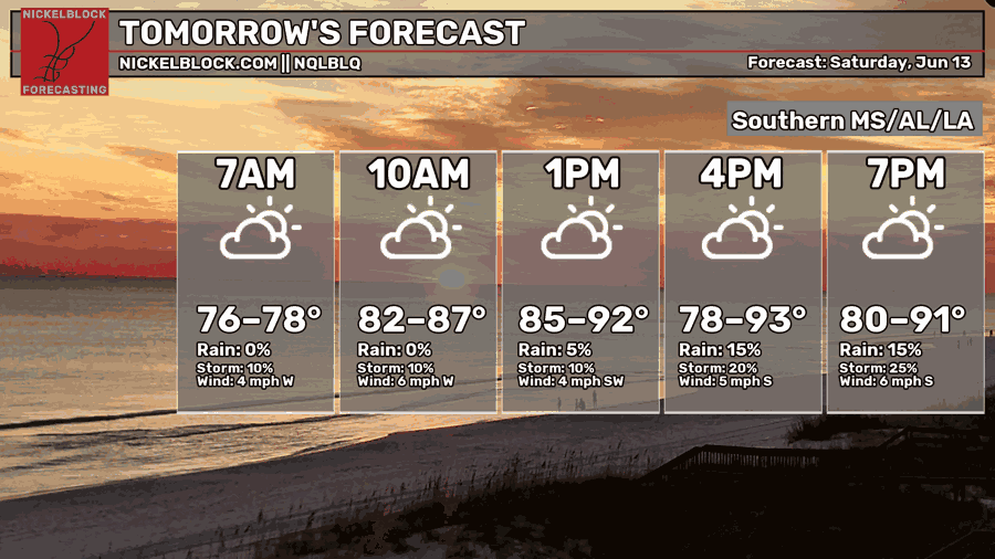
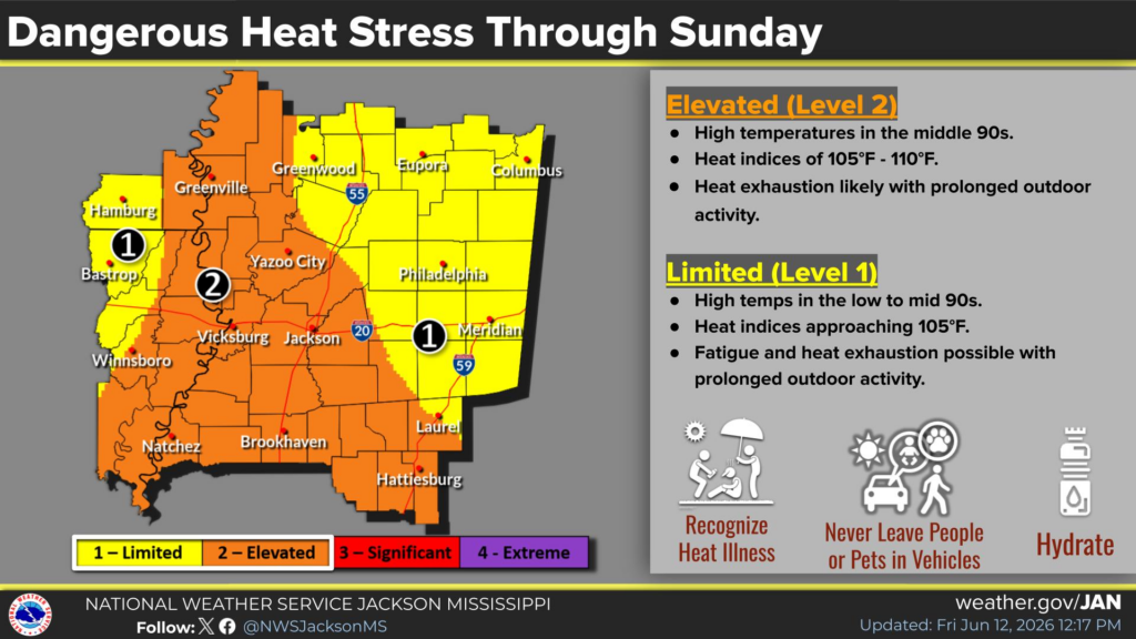
You’ve had a taste of the heat today, and very similar conditions to this afternoon will continue into the weekend. Ridging is in place, which means mostly sunny skies, and elevated heat indices. There is an elevated heat advisory (orange highlighted area below) in effect through Sunday. Areas such as Bogalusa, Jackson, and Brookhaven will feel the worst of the impacts with heat index values around 105–110 F.
It will be very unpleasant, with potentially dangerous heat for sensitive groups or anyone not acclimated to the heat!
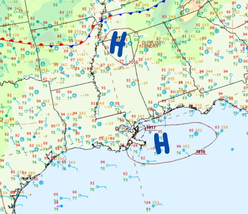
With high pressure in place right at our doorstep (map below), mostly dry conditions will continue through the weekend. Of course, with the exception of a 10% chance for stray showers and thunderstorms along coastal Louisiana and Mississippi during the early evening hours, mainly driven by seabreeze boundaries as they move inland.

THE DAY AFTER TOMORROW
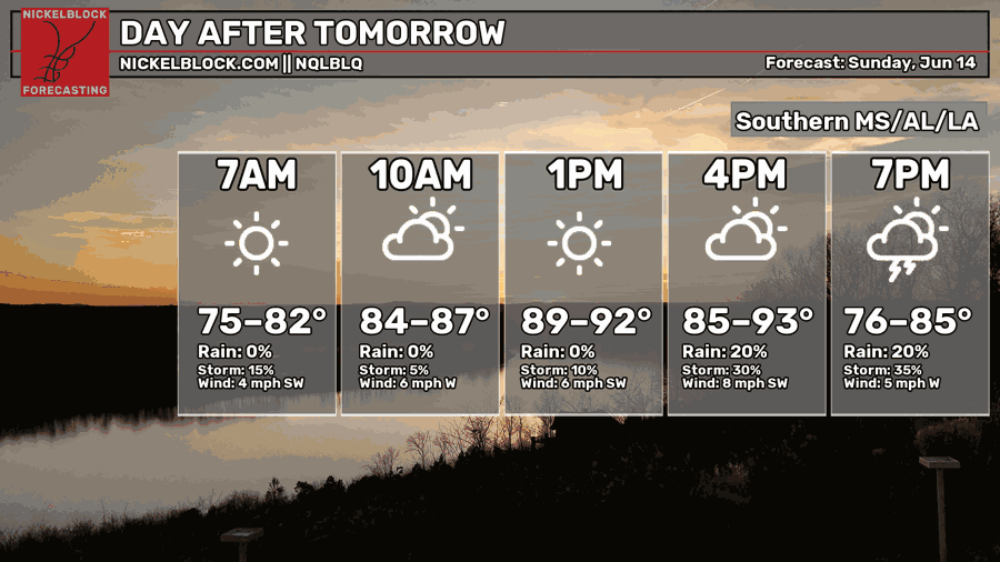
Sunday is going to be hot, as we’ve got a lot of moisture coming in off the Gulf, which is pushing dew points into the upper 70s and making it feel near 100. Showers and thunderstorms will be possible as we head into the overnight Sunday and early Monday morning hours, as a nearby cold front moves in and triggers storms.
EXTENDED OUTLOOK
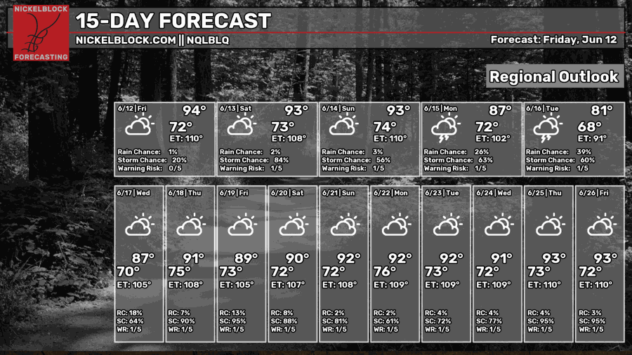
Next week the heat lets us out of its tight grip momentarily at the expense of the dry, clear skies we’ve come to love. A weak cold front will slowly move into our area while the jet stream aloft dips south and provides support for repeated rounds of showers and thunderstorms through mid-week.
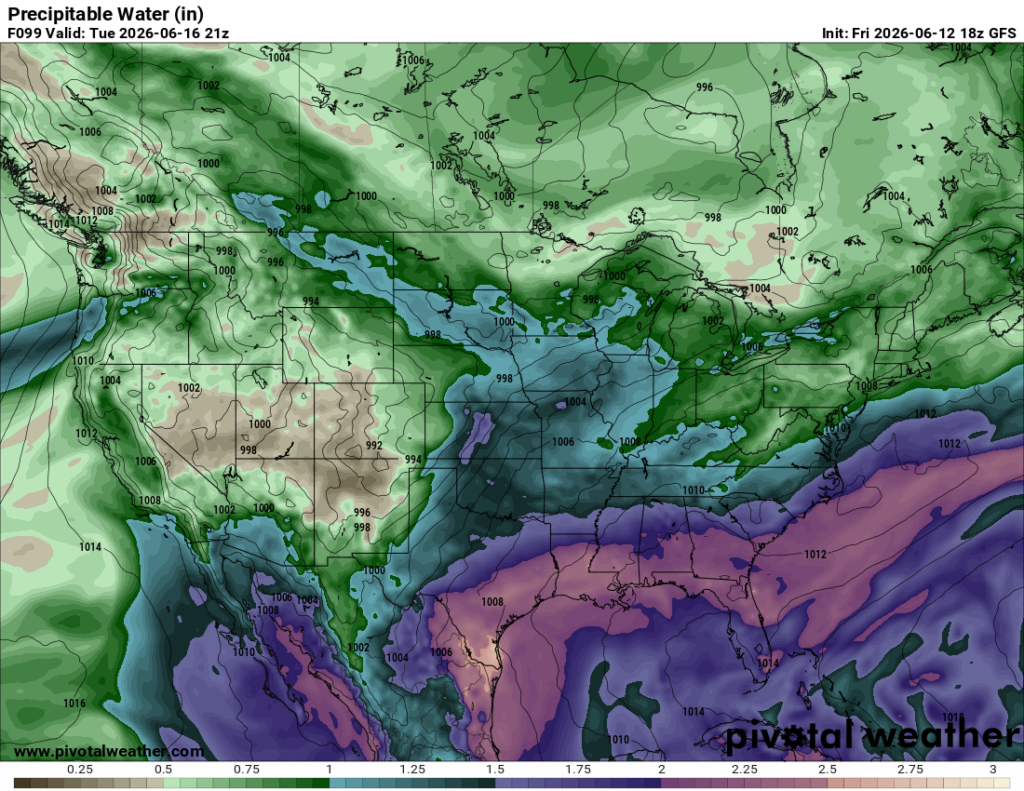
Shown below, we have a ton of available moisture (purples/pinks) being pulled in from the tropics, sitting in the 90th percentile for this time of year…very high! For us, this tropical moisture interacting with the slow-moving cold front will support training/repeated rounds of showers and thunderstorms along the front.
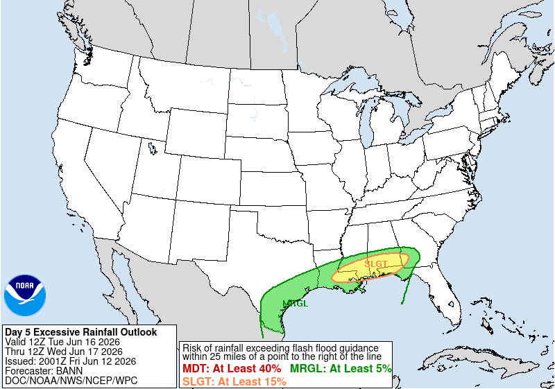
As a result, there is a slight risk for excessive rainfall Tuesday-Wednesday across Louisiana and southern Mississippi. These are areas that have seen significant flooding in the past, so any repeated heavy rain could quickly lead to issues.
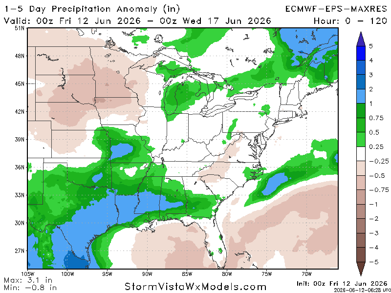
Model guidance is in agreement that next week is soggy for us. We can see why, as 1–5 day precipitation anomalies are running above average along and north of I-10.
DAY-BY-DAY FORECAST
Tonight – Some lingering showers expected to go away in the next hour or so. Mostly clear with lows in the lower 70s.
Saturday – Patchy fog near Baton Rouge in the morning. Partly sunny and hot with a high in the mid 90s. Heat advisory in effect until 8PM for heat indices near 105-110 F. There may be an isolated storm or two in the evening, but most areas will be dry.
Saturday Night – Mostly clear with a low in the mid 70s. Low-end chance of isolated showers.
Sunday– Partly sunny with a chance of afternoon thunderstorms. High in the mid 90s, but experienced temperatures will be near 100 F.
Sunday Night – Showers/storms likely late overnight and into the early morning hours. Otherwise, mostly cloudy with lows in the mid-70s. Rain chance: 40%.
Monday – Widespread thunderstorms likely. Partly sunny with a high in the upper 80s.
Monday Night – Widespread showers and storms likely. Low in the lower 70s and mostly cloudy.
Tuesday – Numerous showers and thunderstorms. Slight risk of excessive rainfall, watch for flooding. High around 80 with mostly cloudy skies.
Tuesday Night – Showers and thunderstorms likely. Slight risk of excessive rainfall, watch for flooding. Mostly cloudy with a low around 70.
Wednesday – Showers and thunderstorms likely. Slight risk of excessive rainfall, watch for flooding. High in the upper 80s and mostly cloudy.
Wednesday Night – Chance of scattered showers and thunderstorms. Mostly cloudy with a low around 70.
Thursday – A chance of showers and thunderstorms. Otherwise, partly sunny, with a highs hovering around 90.
Thursday Night – A chance of showers and thunderstorms otherwise mostly cloudy with lows around 75.
Friday – Partly sunny with highs hovering around 90. Low-end chance of showers/storms.


