As I’m writing this (12:30p CDT), temperatures are climbing into the upper 80s, and skies are pretty much perfectly sunny. Dew points are mostly in the lower 70s and upper 60s, which is a bit sticky, but definitively not terrible compared to most summer days in the deep south.
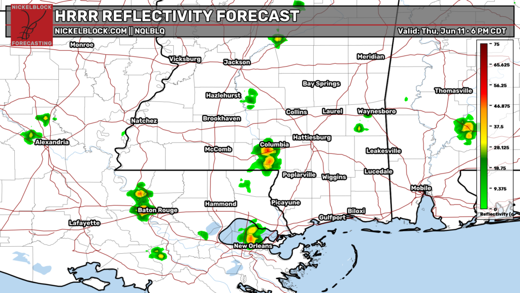
Later tonight, some weak and scattered pop up storms will likely develop across the region, but due to the dryness of the mid levels, they will not be widespread. Most of the storms should be gone by 8 tonight.
Later This Week
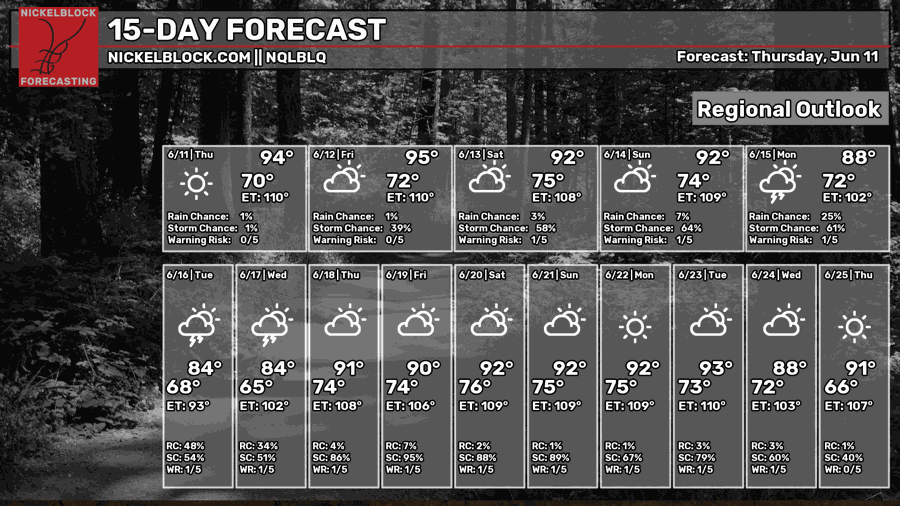
For the rest of this work week and into the weekend, temperatures are going to be hot and sunny, with highs potentially getting up to the mid 90s tomorrow. The chance of rain/storms is also relatively low for the rest of this week and this weekend. Beginning around Tuesday or Wednesday, the ridge pattern that we’re currently in ends with the potential for a cold front to pass through the area bringing rain and cooler temperatures.
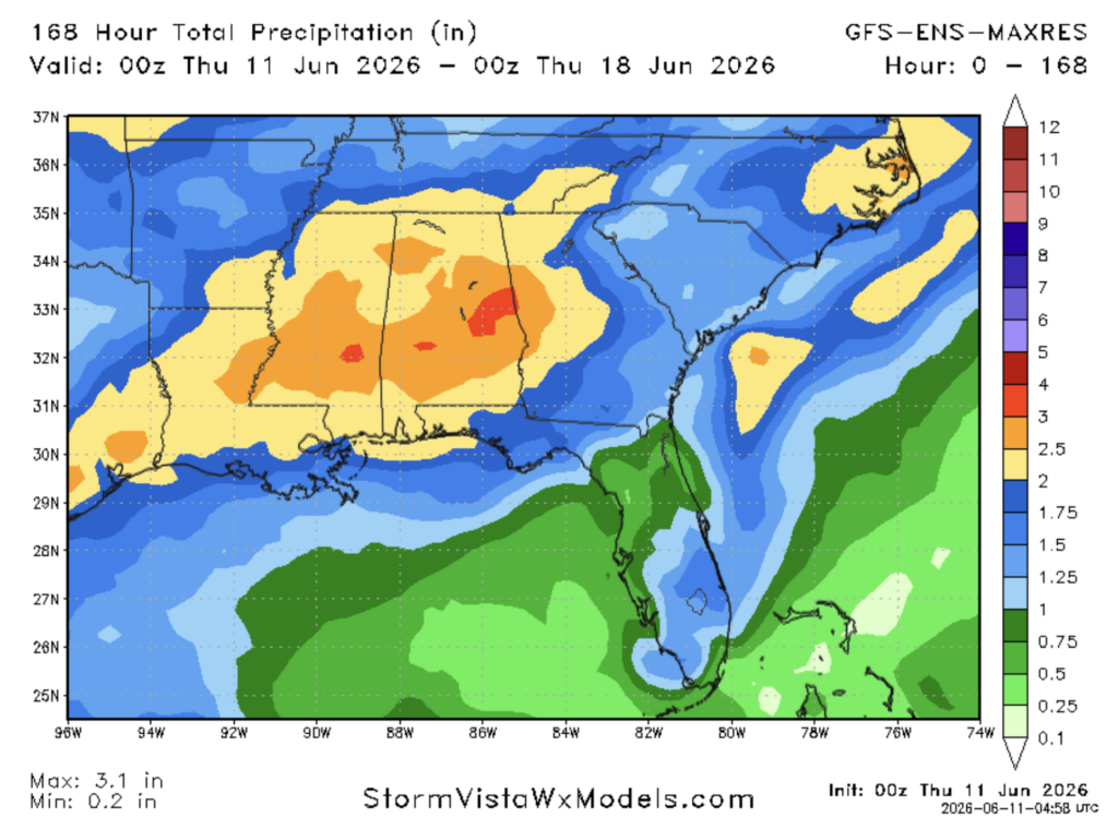
For this cold front event, the GFS Ensemble MAXRES model is pretty bullish on precipitation totals, with a widespread 2-3″ of rain.
Airport Forecast
KHOU/KIAH (Houston) – Current: temperature is 90ºF, dew point is 76ºF, skies are mostly cloudy, wind is gusty coming out of the south at 16 mph, and visibility is 10 miles. Tonight: skies will remain partly cloudy, but no storms are likely. Very minor delays are possible due to gusty winds are possible.
KATL (Atlanta) – Current: temperature is 89ºF, dew point is 69ºF, skies are partly cloudy, wind is coming out of the west at 6 mph, and visibility is 10 miles. Tonight: there is a small chance of thunderstorms this evening, but will be gone by 8 tonight. No delays are likely unless a storm hits the airport directly.
KMSY (New Orleans) – Current: temperature is 88ºF, dew point is 72ºF, skies are partly cloudy, wind is coming out of the south at 10 mph, and visibility is 10 miles. Tonight: skies will remain sunny with little to no chance of storms. No delays are likely.
KBTR (Baton Rouge) – Current: temperature is 90ºF, dew point is 71ºF, skies are mostly sunny, wind is coming out of the south at 9 mph, and visibility is 10 miles. Tonight: skies will remain sunny with no chance of storms. No delays are likely.
KSHV (Shreveport) – Current: temperature is 90ºF, dew point is 75ºF, skies are mostly cloudy, wind is coming out of the south at 13 mph, and visibility is 10 miles. Tonight: skies be mostly sunny with no chance of storms. No delays are likely.
KJAN (Jackson) – Current: temperature is 90ºF, dew point is 73ºF, skies are mostly sunny, wind is coming out of the southwest at 5 mph, and visibility is 10 miles. Tonight: skies will remain sunny with no chance of storms. No delays are likely.
KBHM (Birmingham) – Current: temperature is 91ºF, dew point is 72ºF, skies are partly cloudy, wind is coming out of the southwest at 9 mph, and visibility is 10 miles. Tonight: skies will be mostly sunny with no chance of storms. No delays are likely.
KMOB (Mobile) – Current: temperature is 88ºF, dew point is 70ºF, skies are mostly cloudy, wind is coming out of the south at 7 mph, and visibility is 10 miles. Tonight: skies will remain mostly clear with no chance of storms. No delays are likely.
KTLH (Tallahassee) – Current: temperature is 93ºF, dew point is 63ºF, skies are mostly cloudy, wind is 5 mph, and visibility is 10 miles. Tonight: there is a slight chance of storms this afternoon, but they will likely not cause any issues. Skies will remain mostly clear tonight. No delays are expected.
Highway Forecast
I-10: Some weak scattered thunderstorms may pop up this evening in the area between Houston and New Orleans, but they will certainly not be much of an issue. Storms, if any, should be gone by 8 tonight. Everywhere else, skies will remain mostly sunny for the day with no chance of storms, making for some excellent driving conditions.
I-20: Driving conditions will be excellent for the vast majority of the highway. The only area that may see some pop up storms is in the area between Jackson and Birmingham, but they will not be strong or widespread.
I-49: There is a small chance of some weak pop up storms south of Shreveport, but most of the storms, if any, will fire up to the east of the highway. Overall, driving conditions will be excellent today.
I-55: A storm or two may fire up in the area between Jackson and Laplace, LA, however they will not be strong or widespread. The storms should be gone by 9 tonight. Overall, driving conditions will be excellent today, especially north of Jackson.
I-59: A few scattered storms may develop to the east of Birmingham, but everywhere else driving conditions look excellent. The storms that do develop should be gone by 9 tonight.
I-65: A few scattered storms may develop near Montgomery and should be gone by 8 tonight. They will not be strong or widespread. Everywhere else, driving conditions look excellent.
I-75: In the Georgia portion of the highway, there is pretty much no chance of storms, so driving conditions will be excellent. In the Florida portion, particularly in the area between Lake Okeechobee and Spring Hill, some potentially strong storms may develop tonight due to the sea breeze.
3 Day City Forecast
Tallahassee, FL
Tomorrow: Skies will be mostly sunny with a hot high of 96ºF. Winds will be calm coming out of the north/northwest in the morning gradually shifting to southwesterly by evening. There is a slight chance of storms tomorrow evening. The chance of storms should be gone by around 8 tomorrow night. Temperatures should fall into the upper 70s tomorrow night.
Saturday: Skies will be mostly sunny throughout the day with cloud cover increasing as the day goes on. The high temperature will reach a hot 97ºF. There is a slight chance of storms tomorrow evening before 8 pm. Winds will be calm and coming out of the west for most of the day. Temperatures should fall into the upper 70s Saturday night.
Sunday: Skies will be mostly sunny throughout the day with cloud cover increasing as the day goes on. The high temperature will reach a slightly “cooler” 95ºF. There is a chance of storms Sunday evening and afternoon. Winds will be calm and coming out of the west for most of the day.
Birmingham, AL
Tomorrow: Skies will be mostly sunny throughout the day with a high of 92ºF. There is a chance of south moving thunderstorms tomorrow evening that should pass through the area by 8 tomorrow night. Winds will be calm and gradually becoming more westerly as the day goes on. Temperatures should drop into the mid 70s by tomorrow night.
Saturday: There is a chance of scattered storms throughout the day, but the chance will be close to 0 by the beginning of the night. The high will reach 91ºF. Winds will be calm throughout the day and will gradually become more southerly. Temperatures should reach the mid 70s by Saturday night.
Sunday: Skies will be mostly sunny in the morning and afternoon with a high of 89ºF. There is a chance for storms in the early hours of Sunday. A line of storms may pass through the area later that evening as well. Winds will be relatively calm, starting off southwesterly and becoming more northwesterly as the day goes on. Temperatures should drop into the upper 60s/low 70s Sunday night.
Mobile, AL
Tomorrow: Skies will be mostly sunny throughout the day with a high of 92ºF. There is a slight chance of storms in the evening and late afternoon. Winds will be calm and coming out of the southwest for most of the day. Temperatures should drop into the mid 70s by tomorrow night.
Saturday: Skies will be mostly sunny throughout the day with a high of 92ºF. There is a slight chance of storms in the afternoon and evening. Winds will be calm throughout the day, becoming more westerly as the day goes on. Temperatures should drop into the mid 70s by Saturday night.
Sunday: Skies will be mostly sunny throughout the day with a high of 93ºF. A line of storms may pass through the area a bit later in the evening and night on Sunday, but most storms should be wrapped up by midnight. Winds will be calm and southwesterly in the morning and will shift to become more westerly as the day goes on. Temperatures should be in the mid 70s by Sunday night.
Atlanta, GA
Tomorrow: Skies will be sunny for most of the day tomorrow with a high of 93ºF. There is a slight chance of storms tomorrow evening into the night, but should be done by 11 tomorrow night. Winds will be westerly and calm for most the day tomorrow, with winds shifting slightly to the northwest by night. Temperatures should be in the mid 70s by tomorrow night.
Saturday: Skies will be mostly sunny throughout the day on Saturday with a high of 91ºF. There is a slight chance of storms Saturday afternoon into the evening. Most storms should be gone by 8 Saturday night. Winds will be calm throughout the day, with the wind direction shifting from north/northwesterly in the morning and afternoon to westerly by the evening and night. Temperatures will drop into the mid 70s by Saturday night.
Sunday: Skies will be mostly sunny in the morning and early afternoon on Sunday with a high of 89ºF. In the afternoon, evening, and night there is a good chance of storms. Winds may be a bit gusty throughout the day and will be coming out of the west. Temperatures will drop into the lower 70s Sunday night.
Jackson, MS
Tomorrow: Skies will be sunny for the day tomorrow with a hot high of 94ºF. The chance of storms tomorrow is very low. Winds will be calm tomorrow, gradually becoming more westerly as the day goes on. Temperatures will drop into the mid-upper 70s tomorrow night.
Saturday: Skies will be sunny for most of the day on Saturday with a high of 93ºF. There is a slight chance of storms in the afternoon and evening on Saturday. Winds will be calm and coming of the south and southwest for most of the day tomorrow. Temperatures should fall into the mid 70s by Saturday night.
Sunday: Skies will be mostly sunny throughout the day with a high of 92ºF. Storms are possible in the afternoon and evening on Sunday, with a line of storms that may roll through the area. Winds will be slightly gusty. In the morning, winds will be coming out of the southwest and will shift to be more westerly throughout the day. Temperatures should fall into the low-mid 70s by Sunday night.
New Orleans, LA
Tomorrow: Skies will be mostly sunny throughout the day with a high of 90ºF. There is a slight chance of storms in the late afternoon and evening, but should be mostly gone by 8 tomorrow night. Cloud cover will increase as the day goes on. Winds will be calm coming out of the south for most of the day tomorrow. Temperatures will drop into the mid-upper 70s tomorrow night.
Saturday: Skies will be mostly sunny throughout the day with a high of 92ºF. There is a slight to moderate chance of storms in the afternoon and evening on Saturday, but should be gone by 8 Saturday night. Winds will be calm and coming out of the south for most of the day. Temperatures should drop into the mid-upper 70s by Saturday night.
Sunday: Skies will be mostly sunny throughout the day with a high of 90ºF. There is a good chance of storms in the evening and night. These storms will linger into Monday. Winds will be calm coming out of the south for most of the day, but will shift to be more westerly as night approaches. Temperature should drop into the mid-upper 70s Sunday night.
Baton Rouge, LA
Tomorrow: Skies will be sunny throughout the day with a high of 94ºF. There is no chance of storms or rain. Winds will be slightly gusty coming out of the south for most of the day. Temperature should drop into the mid-upper 70s by tomorrow night.
Saturday: Skies will be mostly sunny throughout the day tomorrow with a high of 92ºF. There is a slight chance of storms in the afternoon and evening, but they should be gone by 8 on Saturday night. Winds will be calm and south/southwesterly for most of the day Saturday. Temperatures should drop into the upper 70s on Saturday night.
Sunday: Skies will be mostly sunny throughout the day on Sunday with a high of 90ºF. There is a good chance of storms Sunday night into the very early hours of Monday. Winds will be south/southwesterly and calm for most of the day on Sunday. Temperatures should drop into the mid-upper 70s on Sunday night.
Shreveport, LA
Tomorrow: Skies will be mostly sunny throughout the day tomorrow with a high of 95ºF. There is no chance of storms tomorrow night. Winds will be calm and southerly to start the day off, then will become more westerly as the day goes on. Temperatures should fall into the upper 70s tomorrow night.
Saturday: Skies will be sunny throughout the day with a hot high of 96ºF. There is a very low chance of storms on Saturday evening. Winds will be relatively calm and coming out of the south for most of the day on Saturday. Temperatures should fall into the upper 70s and lower 80s on Saturday night.
Sunday: Skies will be partly cloudy throughout the day on Sunday with a high of 93ºF. There will be chance of storms in the mid-morning, then a good chance of storms in the evening, night, and going into the early hours of Monday. Winds will be relatively calm coming out of the southwest for most of the day on Sunday. Temperatures should drop into the mid 70s on Sunday night.
Houston, TX
Tomorrow: Skies will be mostly sunny throughout the day tomorrow with a high of 92ºF. Cloud cover will increase as the day goes on, but the chance for storms is very low. Winds will be relatively calm coming out of the south/southeast for most of the day tomorrow. Temperatures will fall into into the mid-upper 70s tomorrow night.
Saturday: Skies will be sunny throughout the day on Saturday with a high of 93ºF. There is a very low chance of storms on Saturday. Winds will be relatively calm and coming out of the southeast in the morning, then will increase, creating gusty conditions in the afternoon. Skies will be mostly clear on Saturday night with temperatures dropping into the upper 70s.
Sunday: Skies will be stormy throughout the afternoon on Sunday with a high of 90ºF. Scattered storms, some of which will be strong, will develop in the afternoon and evening, with widespread scattered storms continuing into the early hours of Monday. Winds will be calm coming out of the southeast on Sunday. Temperatures should drop into the mid-upper 70s on Sunday night.


