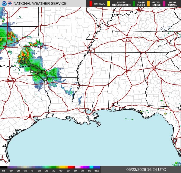
As of 11:45a CDT, our radar looks pretty quiet at the moment. There are some scattered storms and showers in the Shreveport area, but other than that there is no precipitation anywhere else in our region.
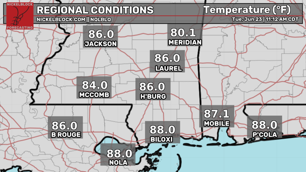
Temperatures are generally in the 80s throughout our region, with warmer temperatures closer to the coast. High temperatures this afternoon will range from the low 80s to the low-mid 90s, with warmer temperatures further south, and cooler temperatures further north.
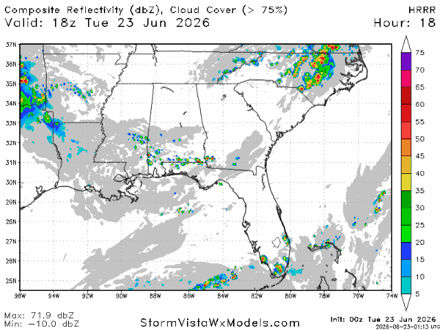
Storms will fire up in areas closer to the coast a bit later tonight. Be on the lookout for some potentially strong storms in the area between Biloxi and Pensacola. Most of the storms should be gone by 10 tonight. These storms will bring heavy rain, lightning, and gusty winds.
Extended Outlook
I mentioned a couple days ago in my local forecast that a heat signal is beginning to develop for our region in the late June/early July period. This signal has persisted, with some models now showing a prominent southeast ridge developing around June 29th.
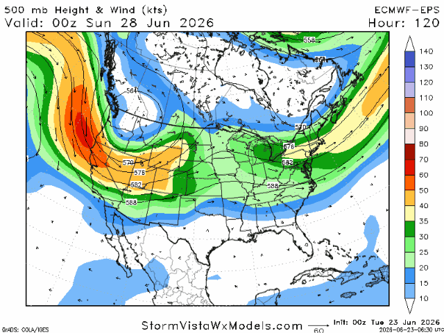
This ridge looks to be centered directly over our region, which means temperatures will likely be hotter than anything we’ve experienced this summer so far.
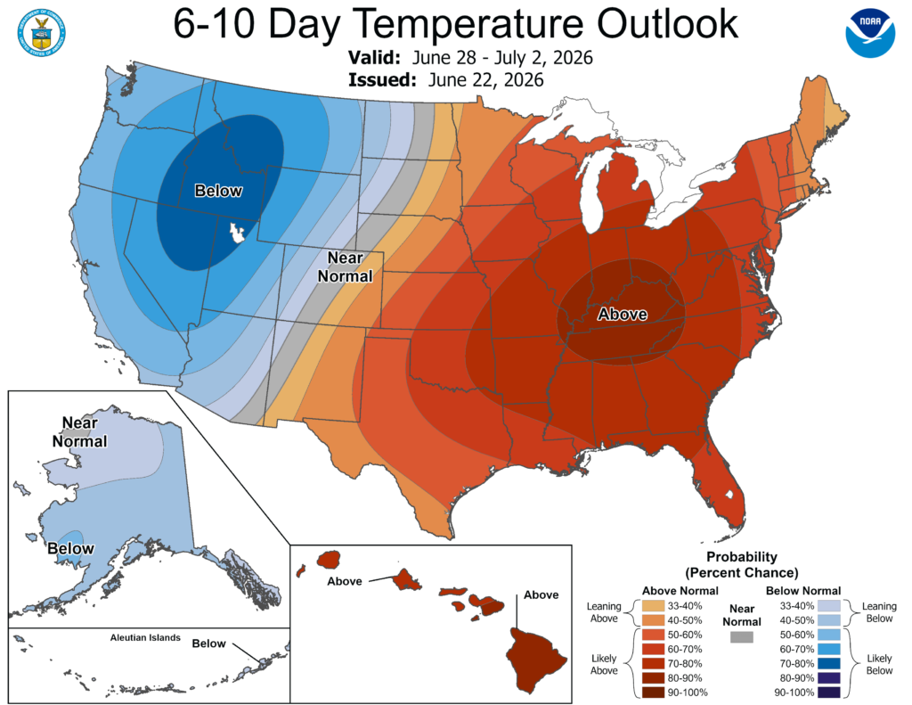
The climate prediction center is picking up on this pattern, and is giving our region a very good chance of experiencing above normal temperatures from June 28-July 2. Below normal precipitation is also fairly likely during this time period as the high pressure from the ridge will suppress daily pop up thunderstorms from intensifying too much.
Airport Forecast
KHOU/KIAH (Houston) – Current: temperature is 90ºF, dew point is 73ºF, skies are partly cloudy, wind is coming out of the southeast at 9 mph, visibility is 10 miles. Tonight: skies will clear up some more and temperatures should fall into the mid 70s. No storms are expected tonight, so no delays are likely.
KATL (Atlanta) – Current: temperature is 83ºF, dew point is 66ºF, skies are partly cloudy, wind is very gusty coming out of the northwest at 16 mph with gusts up to 24 mph, visibility is 10 miles. Tonight: skies will clear up more and wind will calm slightly. Minor delays due to wind are possible.
KMSY (New Orleans) – Current: temperature is 88ºF, dew point is 76ºF, skies are mostly cloudy, wind is coming out of the southwest at 8 mph, and visibility is 10 miles. Tonight: there is a very slight chance of storms tonight between 6 and 9 pm. No delays are likely.
KBTR (Baton Rouge) Current: temperature is 89ºF, dew point is 76ºF, skies are mostly cloudy, wind is gusty coming out of the southwest at 14 mph with gusts up to 18 mph, and visibility is 10 miles. Tonight: there is a slight chance of storms between 5 and 8 pm. Very minor delays are possible.
KSHV (Shreveport) – Current: temperature is 79ºF, dew point is 72ºF, skies are mostly cloudy, wind is coming out of the southwest at 8 mph, and visibility is 10 miles. Tonight: there is a chance of storms tonight, some strong, between the hours of 2 and 10 pm. Some delays are possible.
KJAN (Jackson) – Current: temperature is 86ºF, dew point is 78ºF, skies are mostly cloudy, wind is gusty coming out of the west at 12 mph with gusts up to 16 mph, and visibility is 10 miles. Tonight: there is a slight chance of storms before 7 pm. Minor delays are possible.
KBHM (Birmingham) – Current: temperature is 78ºF, dew point is 64ºF, skies are mostly cloudy, wind is coming out of the north at 10 mph, and visibility is 10 miles. Tonight: skies will clear up more, with no chance of storms. No delays are expected tonight.
KMOB (Mobile) – Current: temperature is 87ºF, dew point is 74ºF, skies are mostly cloudy, wind is coming out of the northwest at 8 mph, and visibility is 10 miles. Tonight: there is a slight chance of thunderstorms later on the night, around 8-9 pm. Some minor delays are possible.
KTLH (Tallahassee) – Current: temperature is 90ºF, dew point is 72ºF, skies are mostly cloudy, wind is gusty coming out of the northwest at 10 mph with gusts up to 23 mph, and visibility is 10 miles. Tonight: there is a slight chance of storms in the evening before 8 pm. Some minor delays are possible.
Highway Forecast
I-10: Some storms are possible tonight between the hours of 5 and 10 pm, especially between Biloxi and Tallahassee. Watch out for gusty winds, water on the road, and lightning. Driving conditions should be fairly decent everywhere else on this highway.
I-20: Some strong storms may develop around 3 or 4 this afternoon around Shreveport and slightly to the east of Shreveport. Watch out for water on the road. These storms should be gone by midnight. Everywhere else, driving conditions should be very good tonight.
I-49: Some strong storms may develop near Shreveport and south of Shreveport and as far south as Alexandria. These storms will develop around 4 this afternoon. The storms south of Shreveport should be gone by 8 tonight, but storms further north will linger until around midnight. Driving conditions will generally be better the further south you go, with poor conditions possible during a storm near Shreveport.
I-55: Some scattered storms may develop this evening near and south of Jackson, but these storms will likely not be too strong. No storms are expected anywhere else along this highway, so driving conditions should be decent tonight.
I-59: Some storms may develop near the MS/AL border, near Meridian around 4 this afternoon. These storms will move out of the area by 8 tonight. Little to no storms are expected elsewhere along this highway, so driving conditions in those areas should be good tonight.
I-65: Some south moving storms will pass through the Mobile area tonight between the hours of 5 and 9 tonight. In that area, watch out for water on the road and gusty winds. Driving conditions may be poor during a thunderstorm. Everywhere else, no storms are forecasted, and driving conditions should be good.
I-75: Driving conditions along this highway will be mostly good tonight. Some scattered storms are possible tonight between 4 and 8 pm near Valdosta and northern Florida, but I anticipate that they will be too far to the west. Overall, driving conditions will be very good.
3 Day City Foorecast
Tallahassee, FL
Tomorrow: Skies will be sunny throughout the day tomorrow with a high of 91ºF. No storms or showers are expected tomorrow. Temperatures should fall into the low 70s by tomorrow night.
Thursday: Skies will be mostly sunny throughout the day, with a high of 95ºF. There is a slight chance of storms in the afternoon and evening on Thursday, as well as late at night. Temperatures will fall into the mid 70s on Thursday night.
Friday: There is a chance of storms and showers in the afternoon and evening Friday afternoon and evening, but most storms should be gone by 8. Before that, skies will be mostly sunny throughout the day with a high of 94ºF. Temperatures will fall into the mid 70s on Friday night.
Birmingham, AL
Tomorrow: Skies will be partly sunny throughout the day, clearing up a bit as the day goes, with a high of 86ºF. There is a very slight chance of showers and thunderstorms in the afternoon and evening. Temperatures should fall into the upper 60s tomorrow night.
Thursday: Skies will be mostly sunny throughout the day with a high of 89ºF. There is a slight chance of showers and storms in the afternoon and evening. Temperatures should fall into the low 70s on Thursday night.
Friday: Skies will be mostly sunny throughout the day with a high of 91ºF. No showers and thunderstorms are expected on Friday. Temperatures should fall into the mid 70s on Friday night.
Mobile, AL
Tomorrow: Skies will be mostly sunny throughout the day tomorrow with a high of 90ºF. There is a chance of some stronger storms that may roll through the area from the northwest between the hours of 6 and 9 pm tomorrow night. These storms may persist until after midnight. Temperatures should fall into the low 70s tomorrow night.
Thursday: Skies will be partly sunny throughout the day on Thursday with a high of 91ºF. There is a good chance of showers and thunderstorms on Thursday afternoon and evening. Temperatures should fall into the mid 70s on Thursday night.
Friday: Skies will be mostly sunny throughout the day on Friday with a high of 90ºF. There is a slight chance of showers and thunderstorms in the afternoon and evening. Temperatures should fall into the mid 70s on Friday night.
Atlanta, GA
Tomorrow: Skies will be sunny throughout the day tomorrow with a high of 86ºF. There is no chance of showers and storms tomorrow afternoon and evening. Temperatures should fall into the upper 60s tomorrow night.
Thursday: Skies will be mostly sunny throughout the day, though cloud cover will increase slightly as the day goes on. The high will reach 89ºF. There is no chance of showers and storms in the afternoon and evening. Temperatures should fall into the low 70s on Thursday night.
Friday: Skies will be mostly sunny throughout the day on Friday with a high of 91ºF. There is a slight chance of showers and storms between the hours of 2 and 8 pm. Temperatures should fall into the mid 70s on Friday night.
Jackson, MS
Tomorrow: Skies will be partly sunny throughout the day tomorrow with a high of 88ºF. There is a high chance of showers and storms, some strong, in the afternoon going into into the night. Expect rainfall amounts between a quarter inch and an inch of rain, with higher amounts in thunderstorms. Temperatures should fall into the low 70s tomorrow night.
Thursday: Skies will be mostly sunny throughout the day on Thursday with a high of 91ºF. Thunderstorms are possible beginning in the early afternoon until the evening. Skies will clear up Thursday evening and temperatures will drop into the low-mid 70s.
Friday: Skies will be sunny throughout the day on Friday with a high of 93ºF. There is little to no chance of showers and storms on Friday afternoon and evening. Skies will remain sunny to mostly clear going into Friday night, when temperatures will drop into the mid 70s.
New Orleans, LA
Tomorrow: Skies will be mostly sunny throughout the day tomorrow with a high of 92ºF. There is a slight chance of storms in the evening and night tomorrow, but these storms may be too far east. Temperatures should fall into the mid-upper 70s tomorrow night.
Thursday: Skies will be mostly sunny throughout the day on Thursday with a high of 93ºF. There is little to no chance of storms Thursday afternoon and evening. Temperatures should fall into the mid-upper 70s on Thursday night.
Friday: Skies will be sunny throughout the day on Friday with a high of 92ºF. There is again no chance of storms and showers on Friday afternoon and evening. Temperatures should fall into the mid-upper 70s on Friday night.
Baton Rouge, LA
Tomorrow: Skies will be mostly sunny throughout the day tomorrow with a high of 93ºF. Some storms are possible tomorrow beginning around 5 and ending around 9. Cloud cover will increase as the day goes on and temperatures should fall into the mid 70s tomorrow night.
Thursday: Skies will be sunny throughout the day on Thursday with a high of 95ºF. There is no chance of storms or showers Thursday afternoon and evening. Skies will clear up as the day goes on, remaining clear by night. Temperatures should fall into the mid 70s on Thursday night.
Friday: Skies will be sunny throughout the day on Friday with a high of 94ºF. There is no chance of storms and showers Friday afternoon or evening. Skies will clear up as the day goes on. Temperatures should fall into the mid 70s on Friday night.
Shreveport, LA
Tomorrow: Skies will be mostly sunny throughout the day tomorrow with a high of 93ºF. There is a slight chance of storms in the early morning, then another slight chance of storms in the afternoon and evening. Temperatures should fall into the mid 70s tomorrow night.
Thursday: Skies will be sunny throughout the day on Thursday with a high of 93ºF. There is no chance of storms or showers Thursday afternoon and evening. Skies will clear up as the day goes on, with clear skies expected by night. Temperatures should fall into the mid 70s on Thursday night.
Friday: Skies will be mostly sunny throughout the day with a high of 94ºF. There is no chance of storms and showers Friday afternoon or evening. Skies will clear up as the day goes on, with clear skies expected by night. Temperatures should fall into the mid-upper 70s on Friday night.
Houston, TX
Tomorrow: Skies will be mostly sunny throughout the day tomorrow with a high of 95ºF. There is little to no chance of showers and storms tomorrow afternoon and evening. Skies will be mostly clear by tomorrow night, when temperatures should fall into the mid 70s.
Thursday: Skies will be mostly cloudy in the morning, but should clear up to become mostly clear by night. The high will reach 94ºF. There is no chance of storms and showers on Thursday. Temperatures should fall into the mid-upper 70s on Thursday night.
Friday: Skies will be sunny throughout the day on Friday with a high of 94ºF. There is no chance of storms and showers on Friday. Skies will become clear by night, when temperatures should fall into the upper 70s.


