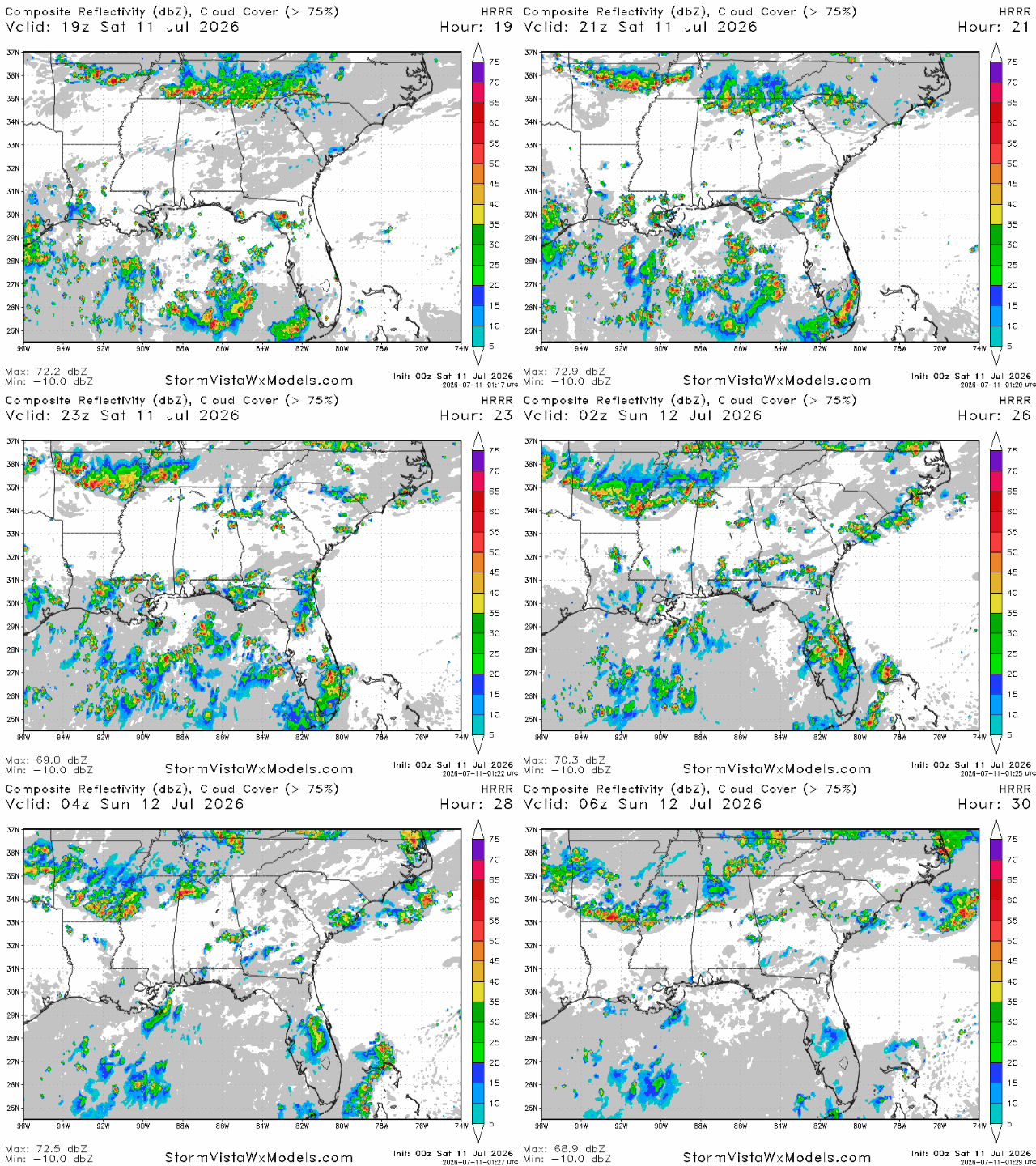
Good afternoon! Currently on our radar, we have a couple areas of storminess. One in the New Orleans area and one in western Louisiana. The storms in those areas will persist into this evening, when other storms along the coast will form. This is due to the sea breeze, which interacts with the drier air to the north, forcing the moist air over the ocean to rise, creating convection and storms.
While there is certainly sufficient heat and humidity to create potent storms, the storms that form will pop up so quickly and vigorously that they’ll burn through their energy too quickly to become organized and therefore more damaging. Rainfall totals will be pretty light in areas closer to the coast, but some localized places hit directly by a storm may receive significant rain.
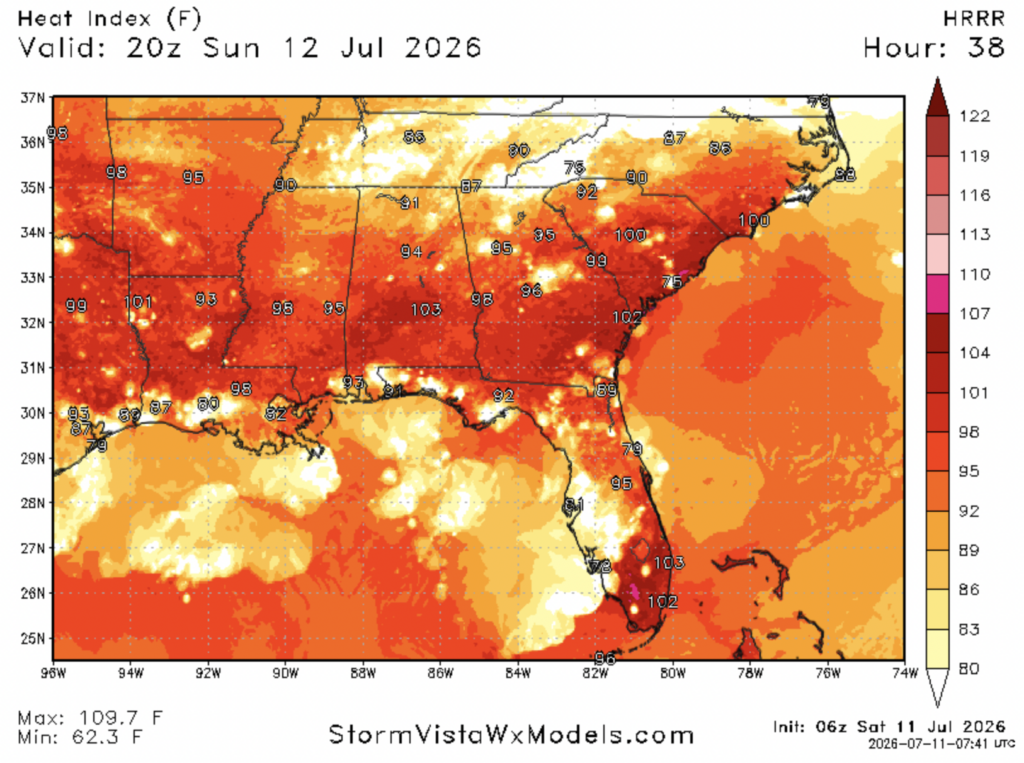
Moving into tomorrow, we’re expected to see more hot and muggy conditions across our region, with widespread heat indices in the upper 90s and low 100s.
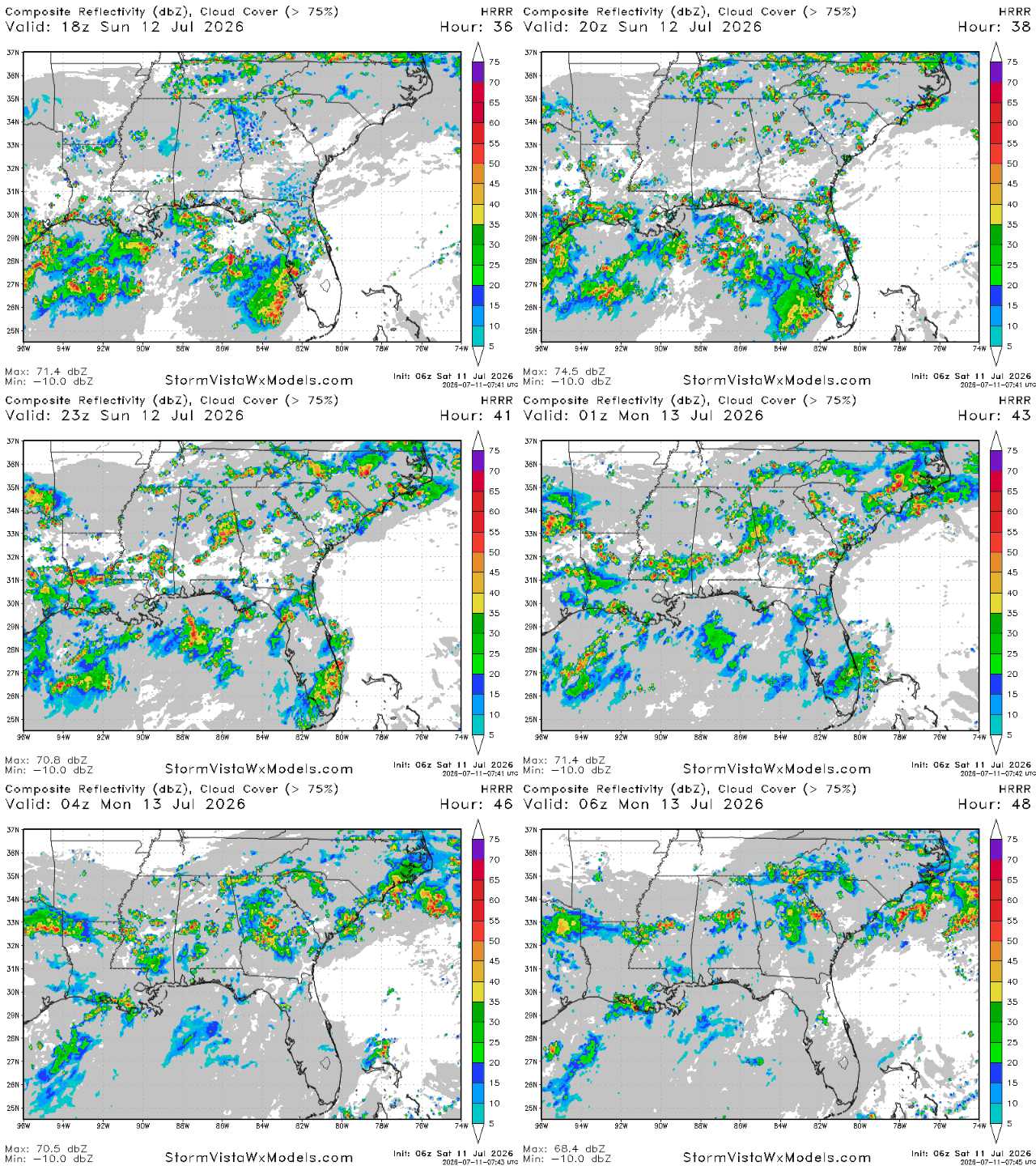
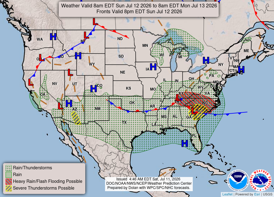
This heat will come to an abrupt end tomorrow evening, when some potentially robust storms may pass through the area, ushering in a backdoor cold front that will bring us cooler and wetter conditions for the early part of this week.
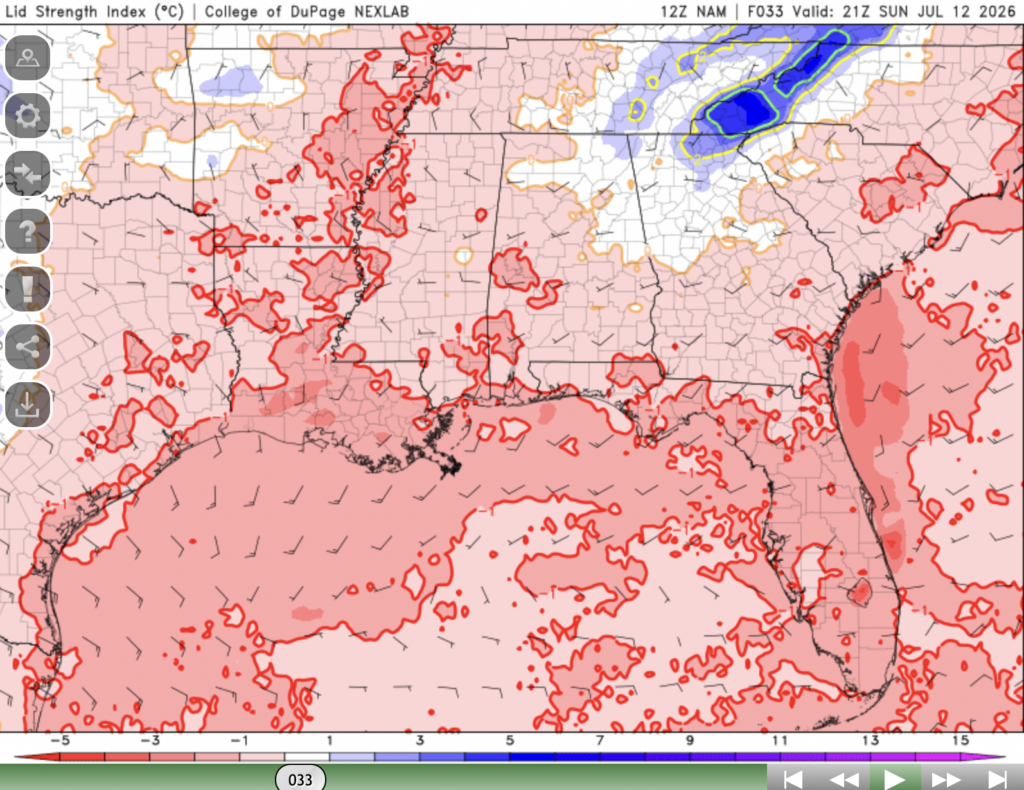
The strength of these storms mostly has to do with the lid strength index being closer to 0 tomorrow in parts of our region. The lid strength index is a measure of how much thunderstorm development will be suppressed by warm and dry air in the mid layers of the atmosphere. If it’s too high, storm development will be completely suppressed, and if its too low, storms will burn through their energy too quickly, leading to disorganized and weak storms.
Tomorrow, we’ve got the best of both worlds, where the lid strength index won’t be too low or too high, leading to some potentially robust storms.
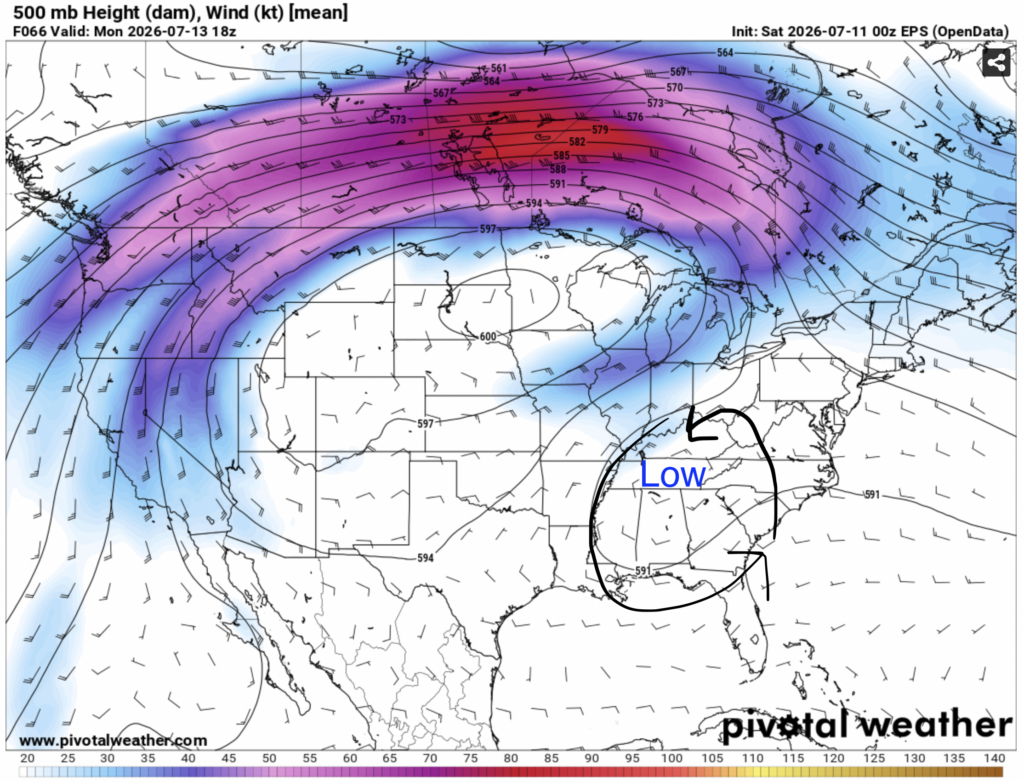
After tomorrow, an area of low pressure will move into our area from up north, bringing us cooler and wetter conditions from Monday-Wednesday.
Airport Forecast
KHOU/KIAH (Houston) – Current: temperature is 88ºF, dew point is 74ºF, skies are mostly cloudy, winds are coming out of every which direction at 3 mph, and visibility is 10 miles. Tonight: there is a slight chance of showers tonight that will be mostly over before 7 pm. No delays are expected.
KATL (Atlanta) – Current: temperature is 92ºF, dew point is 70ºF, thunderstorms are currently hitting the airport, winds are coming out of the west at 15 mph with gusts up to 23 mph, and visibility is 10 miles. The chance of storms will continue into the night. Some delays are possible.
KMSY (New Orleans) – Current: temperature is 89ºF, dew point is 76ºF, thunderstorms are currently hitting the airport, winds are coming out of the northeast at 7 mph, and visibility is 10 miles. Storms are likely this afternoon and evening, with a potential for flash flooding. Expect delays and cancellations.
KBTR (Baton Rouge) Current: temperature is 91ºF, dew point is 75ºF, skies are overcast, winds are coming out of the northwest at 6 mph, and visibility is 10 miles. The chance of storms will persist until around 7 tonight. Some delays are possible.
KSHV (Shreveport) – Current: temperature is 91ºF, dew point is 73ºF, skies are mostly cloudy, winds are coming out of every which direction at 5 mph, and visibility is 10 miles. There is a chance of storms, mostly before 7 pm, then skies will clear out. Minor delays are possible.
KJAN (Jackson) – Current: temperature is 93ºF, dew point is 73ºF, skies are partly cloudy, winds are coming out of every which direction at 3 mph, and visibility is 10 miles. Skies will clear up some more, and remain clear tonight. No delays are expected.
KBHM (Birmingham) – Current: temperature is 92ºF, dew point is 74ºF, skies are mostly cloudy, winds are coming out of the southwest at 6 mph with gusts up to 17 mph, and visibility is 10 miles. There is a chance of some weaker storms tonight, but most will be gone by 8. Minor delays are possible.
KMOB (Mobile) – Current: temperature is 77ºF, dew point is 73ºF, skies conditions are thunderstorms with light rain, winds are coming out of the northwest at 6 mph, and visibility is 10 miles. The chance of storms and showers will persist until around 10 tonight. Some delays are possible.
KTLH (Tallahassee) – Current: temperatures is 95ºF, dew point is 71ºF, skies are partly cloudy, winds are coming out of the west at 9 mph, and visibility is 10 miles. There is a chance of storms tonight until around 9-10 pm. Minor delays are possible.
Highway Forecast
I-10: Some scattered pop up storms are likely tonight before 8, particularly new New Orleans and Biloxi. There is a chance for storms elsewhere along this highway, mostly along the coast. Overall, driving conditions will be somewhat poor.
I-20: Some storms may roll through the Birmingham area and northern Georgia portion of this highway late tonight, between 8 pm and midnight, but storms are unlikely everywhere else. Overall, driving conditions will be decent tonight.
I-49: Some storms are possible tonight between Alexandria and Lafayette, but storms are fairly unlikely north of Alexandria. Overall, driving conditions will be decent tonight.
I-55: Storms are likely between Jackson and Laplace, LA tonight, mostly before 7 pm, as well as up near Memphis and the TN/MS border between 5 and 8 tonight. In between those 2 areas, driving conditions should be very good. Watch out for water on the roads, potentially gusty winds, and heavy rain.
I-59: Some weak storms are possible this afternoon and evening near Laurel and Hattiesburg, as well as a bit later tonight in the Birmingham area. Most storms should be gone by 9-10 tonight. Overall driving conditions will be average to slightly poor tonight.
I-65: Some sea breeze storms are likely this evening near Mobile, and more potent storms are possible up near Decatur, AL to south of Birmingham between 5 pm and midnight tonight. In between, driving conditions look decent.
I-75: A few storms are currently in the Atlanta area, and will continue to pass through the area into the evening. Storm development is also possible this evening near the FL/GA border, lasting until around 9-10 tonight. In between, driving conditions look decent.
3 Day City Forecast
Tallahassee, FL
Tomorrow: Skies will be mostly sunny throughout the day tomorrow with a high of 94ºF. Scattered storms will develop tomorrow evening going into the night, with rainfall amounts likely to be between a tenth to a quarter of an inch. Most storms will be gone by 10 tomorrow night, but some may linger. Temperatures should fall into the mid 70s by tomorrow night.
Monday: There is a chance of scattered storms in the morning going into the afternoon with a high of 90ºF. The chance of storms will linger for the entire day, lasting into the night. Temperatures should fall into the low-mid 70s by Monday night.
Tuesday: Skies will be partly sunny throughout the day on Tuesday with a high of 91ºF. The chance of storms will begin in the early afternoon, lasting until the late evening. Skies will be partly cloudy on Tuesday night when temperatures should fall into the mid 70s.
Birmingham, AL
Tomorrow: Skies will be partly sunny tomorrow with a high of 89ºF. There is a chance of storms in the early morning, then another one in the late afternoon and evening, lasting until around midnight. Skies will remain cloudy into the night, when temperatures should fall into the low 70s.
Monday: Skies will be partly sunny throughout the day on Monday with a high of 87ºF. Showers and storms will pass through the area beginning in the early afternoon until past midnight. Skies will be mostly cloudy going into the night when temperatures should fall into the low 70s.
Tuesday: Skies will be partly sunny throughout the day on Tuesday with a high of 87ºF. The chance of showers and storms will begin in the early afternoon on Tuesday lasting until past midnight. Skies will be mostly cloudy on Tuesday night when temperatures will fall into the low 70s.
Mobile, AL
Tomorrow: Skies will be mostly sunny throughout the day on Sunday with a high of 92ºF. Thunderstorms will begin before lunchtime, lasting until past midnight. Cloud cover will increase as the day goes on, and by night sky conditions will be mostly cloudy and temperatures will drop into the mid 70s.
Monday: Skies will be mostly cloudy for the day on Monday with a high of 86ºF. The chance of showers and storms will persist for pretty much the entire day beginning in the morning lasting until the late evening and the beginning of the night. By nightfall, sky conditions will be mostly cloudy and temperatures should fall into the low 70s.
Tuesday: Skies will be partly sunny throughout the day on Tuesday with a high of 89ºF. Storms and showers are possible beginning in the early afternoon and lasting until night. By Tuesday night, sky conditions will be mostly cloudy and temperatures should fall into the low 70s.
Atlanta, GA
Tomorrow: Skies will be partly sunny throughout the day tomorrow with a high of 89ºF. Potentially strong storms will begin to fire up in the late afternoon lasting until after midnight. Cloud cover will increase as the day goes on, and by night skies will be mostly cloudy and temperatures should drop into the low 70s.
Monday: Skies will be mostly cloudy throughout the day on Monday with a high of 85ºF. Showers and storms from the night before may linger until the late morning, then showers and storms will fire up in the mid afternoon lasting until around 10-11 pm. By Monday night, skies will remain cloudy and temperatures should fall into the low 70s.
Tuesday: Skies will be mostly cloudy throughout the day on Tuesday with a high of 85ºF. Showers and thunderstorms are likely throughout the day until around 8 pm. Cloud cover will persist into the night when temperatures should drop into the low 70s.
Jackson, MS
Tomorrow: Skies will be mostly sunny throughout the day tomorrow with a high of 90ºF. Potentially strong storms will fire up in the late afternoon, lasting until after midnight. Skies will be mostly cloudy tomorrow night when temperatures should fall into the low 70s.
Monday: Skies will be mostly cloudy throughout the day on Monday with a high of 88ºF. Showers and storms will begin in the early afternoon lasting until around 10 pm. Skies will remain mostly cloudy into the night when temperatures should fall into the low 70s.
Tuesday: Skies will be partly sunny throughout the day on Tuesday with a high of 88ºF. Some showers and storms are possible throughout the day on Tuesday beginning in the late morning and lasting until past midnight. By night, skies will be partly cloudy and temperatures should fall into the low 70s.
New Orleans, LA
Tomorrow: Skies will be mostly sunny throughout the day tomorrow with a high of 90ºF. Some storms are possible in the afternoon and evening tomorrow. Cloud cover will increase as the day goes on, with mostly cloudy conditions expected by night when temperatures should fall into the mid-upper 70s.
Monday: Skies will be mostly cloudy throughout the day on Monday with a high of 85ºF. Showers and storms will persist all day on Monday. By night, skies will be mostly cloudy and temperatures should fall into the mid 70s.
Tuesday: Skies will be mostly cloudy throughout the day on Tuesday with a high of 87ºF. Showers and storms will persist all day again, lasting until after midnight. By night, skies will remain mostly cloudy and temperatures should fall into the mid 70s.
Baton Rouge, LA
Tomorrow: Skies will be partly cloudy tomorrow with a high of 91ºF. Storms will begin in the early afternoon lasting until 10-11 pm. Cloud cover will increase as the day goes on, and by night skies will be mostly cloudy and temperatures should fall into the mid 70s.
Monday: Skies will be mostly cloudy throughout the day on Monday with a high of 86ºF. Showers and storms will persist all day beginning in the early morning. Skies will remain cloudy by night when temperatures should drop into the low-mid 70s.
Tuesday: Skies will be mostly cloudy throughout the day on Tuesday with a high of 88ºF. Showers and storms will persist all day again, lasting until past midnight. Mostly cloudy conditions will persist into the night when temperatures should drop into the low-mid 70s.
Shreveport, LA
Tomorrow: Skies will be mostly sunny throughout the day tomorrow with a high of 92ºF. Storms will begin a bit later around 6 pm lasting until after midnight. Cloud cover will increase as the day goes on, and by night skies will be mostly cloudy and temperatures will fall into the mid 70s.
Monday: Skies will be partly sunny throughout the day on Monday with a high of 88ºF. Storms will begin in the morning and will last for most of the day until past midnight. Skies will become partly cloudy by night when temperatures should drop into the low-mid 70s.
Tuesday: Skies will be partly sunny throughout the day on Tuesday with a high of 89ºF. There is a slight chance of showers and storms beginning in the afternoon and lasting until the evening. By night, skies will be partly cloudy and temperatures should fall into the low-mid 70s.
Houston, TX
Tomorrow: Skies will be partly sunny throughout the day tomorrow with a high of 91ºF. Storms will fire up tomorrow in the early afternoon, continuing until around 7-8 pm. Skies will be mostly cloudy by tomorrow night when the temperature should drop into the upper 70s.
Monday: Skies will be mostly cloudy on Monday with a high of 89ºF. The chance of storms and showers will persist throughout the day until the night. Mostly cloudy sky conditions will remain into the night, when temperatures should fall into the mid-upper 70s.
Tuesday: Skies will be mostly cloudy on Tuesday with a high of 88ºF. Storms and showers will linger throughout the day until after midnight. Skies will remain mostly cloudy going into Tuesday night when temperatures should fall into the mid-upper 70s.


