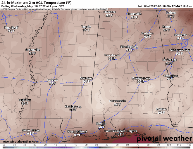
As we had through the next few days, things will be pretty warm. Nothing new there, I suppose. Temperatures will continue to run in the 90s with a Heat Index up around 100 degrees.
Once we get through the heat, we will get back into a shot for some rain starting on Saturday, through Sunday, Monday and into Tuesday or next week. The rain will come with a chance for storms and the potential for some strong storms – though severe weather looks less likely – with brief heavy rain, gusty wind, and small hail possible. The tornado threat is very low.
Rainfall totals between the GFS and Euro suggests up to 3″ of rain. The NBM is running a bit lower with rainfall total s(that’s normal) but still shows a chance for more than 1″ of rain for the area.
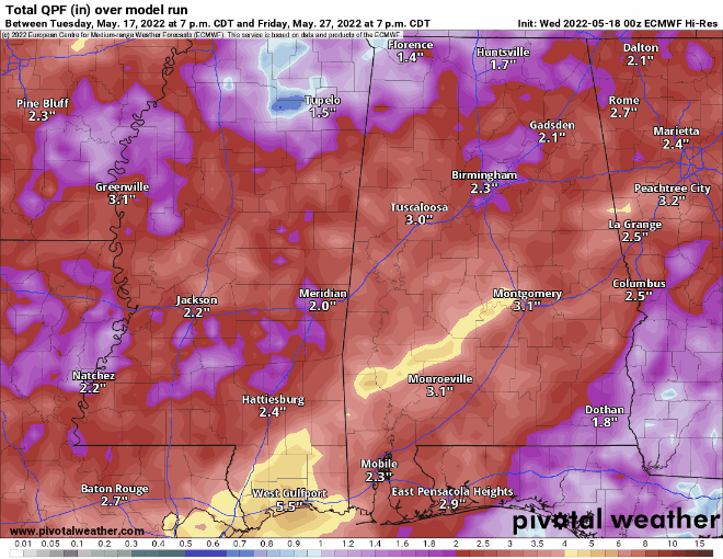
If the pattern shakes out like it is being shown in the model guidance, CurerntIy. I’m leaning toward higher rainfall totals with some localized spots potentially seeing up to 6″ of rain by the time it is all said and done. And since the 6″ of rain would fall over four or five days, flooding isn’t much of a concern.
Once we break out of this pattern by the end of next week, things start to settle into more of a Summer pattern for a few days with the return of the seabreeze and afternoon storms.
Day to Day Forecast
Today
Mostly sunny with a 10-percent chance for storms. Highs in the mid 90s.
Tonight
Mostly clear. Patchy fog after midnight. Lows in the upper 60s.
Thursday
Patchy fog in the morning, then mostly sunny. Highs in the mid 90s.
Thursday Night
Partly cloudy. Lows in the upper 60s.
Friday
Mostly Sunny with a 10-percent chance for an afternoon storm. Highs in the lower 90s.
Friday Night
Partly cloudy. Lows in the lower 70s.
Saturday
Mostly cloudy with a 60-percent chance for afternoon storms. Some may be strong, few (if any) will be severe. Highs around 90.
Saturday Night
Showers and thunderstorms possible overnight. Lows in the upper 60s. Chance of rain 40-percent.
Sunday
Mostly cloudy with more rain and storms possible. Highs in the lower 80s. Chance of rain 60-percent.
Sunday Night
Mostly cloudy with storms possible before midnight. Lows in the mid 60s. Chance of rain 40-percent.
Monday
Partly sunny with a chance of showers and thunderstorms. Highs in the mid 80s. Chance of rain 40-percent.
Monday Night
Mostly cloudy. Lows in the mid 60s.
Tuesday
Partly sunny with a 30-percent chance for an afternoon storm. Highs in the upper 80s.


