Another hot one today, with afternoon highs around 105F. I will say that I do have some good (ish) news to pass along: there is low-end chance for a few small isolated showers and storms.

The big ridge of high pressure responsible for all of this heat may have just enough of a crinkle in it today and tomorrow to allow for a wayward shower or storm to develop.
If one develops near you, I’d buy a lottery ticket because it is going to be your lucky day! I wouldn’t expect any shower or storm to drop much meaningful rain, but it may be enough to temper the heat slightly.
We will see the same setup again for tomorrow. Highs between 100F and 105F with an outside shot for an isolated storm.
I will say there is now a new area to watch in the Tropics. If you watched my forecast video on Tuesday, we spent some time discussing this.
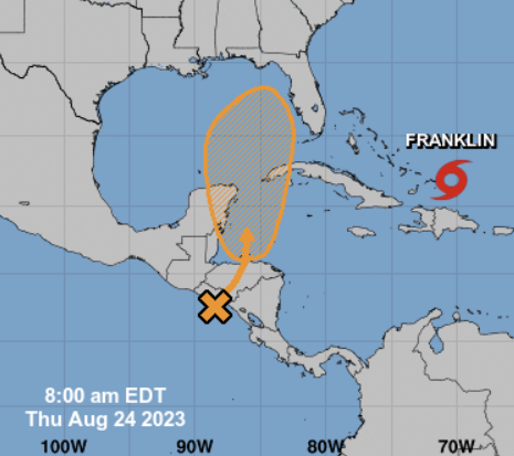
From the NHC:
A broad area of low pressure, originating along the East Pacific coast of Central America, is forecast to move into northwestern Caribbean Sea by this weekend. Some gradual development of this system is possible thereafter into early next week, and a tropical depression could form while it moves slowly northward, entering the eastern Gulf of Mexico.
Formation chance through 48 hours…low…10 percent.
Formation chance through 7 days…medium…50 percent.
The speed of development will dictate where this thing goes. The longer it takes to develop, the higher the chance that it gets closer to us. The faster it develops, the higher the likelinood that it moves out to sea toward the east.
[wpcode id=”41149″]
REGIONAL DAY TO DAY FORECAST
Today: Mostly sunny. A slight chance of showers and thunderstorms in the afternoon. Hot with highs around 100F to 105F. East winds around 5 mph, becoming southeast in the afternoon. Chance of rain 20 percent. Heat index values up to 114.
Tonight: Mostly clear. Humid with lows in the mid 70s. South winds 5 to 10 mph. Heat index values up to 106 early in the evening.
Friday: Sunny. A slight chance of showers and thunderstorms in the afternoon. Hot with highs around 100. Northeast winds around 5 mph, becoming southeast in the afternoon. Chance of rain 20 percent. Heat index values up to 109.
Friday Night: Mostly clear. Lows in the mid 70s. Southwest winds around 5 mph. Heat index values up to 105 early in the evening.
Saturday: Sunny. A slight chance of showers and thunderstorms in the afternoon. Hot with highs around 100. Chance of rain 20 percent. Heat index values up to 110.
Saturday Night: Mostly clear. Lows in the mid 70s. Heat index values up to 105 early in the evening.
Sunday: Sunny. A slight chance of showers and thunderstorms in the afternoon. Hot with highs around 100. Chance of rain 20 percent. Heat index values up to 115.
Sunday Night: Mostly clear. Lows in the mid 70s. Heat index values up to 105 early in the evening.
Monday: Sunny. A chance of showers and thunderstorms in the afternoon. Hot with highs around 100. Chance of rain 30 percent. Heat index values up to 115.
Monday Night: Partly cloudy in the evening, then clearing. A slight chance of showers and thunderstorms. Lows in the mid 70s. Chance of rain 20 percent.
Tuesday: Mostly sunny. A slight chance of showers and thunderstorms in the morning, then a chance of showers and thunderstorms in the afternoon. Highs in the upper 90s. Chance of rain 50 percent. Heat index values up to 105.
Tuesday Night: Partly cloudy. A chance of showers and thunderstorms, mainly in the evening. Lows in the lower 70s. Chance of rain 50 percent.
Wednesday: Sunny. A slight chance of showers and thunderstorms in the morning, then a chance of showers and thunderstorms in the afternoon. Highs in the mid 90s. Chance of rain 40 percent.


