Howdy!
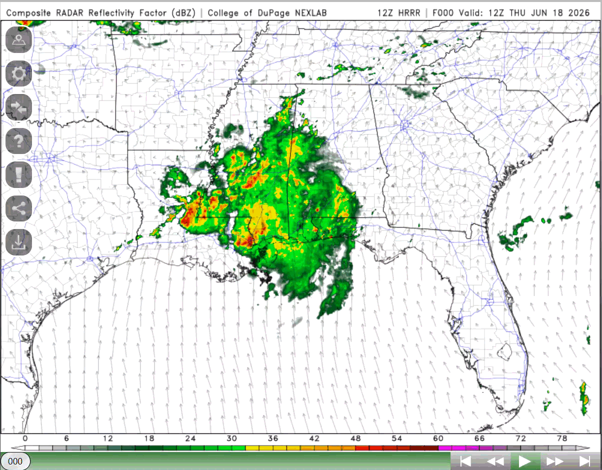
Post Tropical Cyclone Arthur has moved overland over Louisiana into Mississippi and is producing heavy rainfall, tornado warnings, strong winds, and severe weather. As we can see in the NWS radar, much is happening currently in the southeast United States.
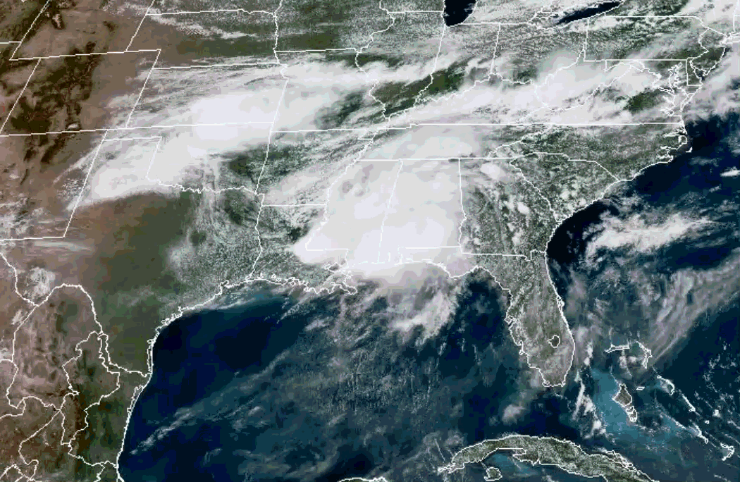
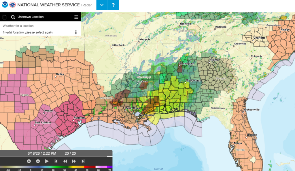
The rain that we are seeing will continue today into the weekend. Flash flooding is very possible for a lot of people, so do take these warnings seriously and see how they will impact you relative to your location.
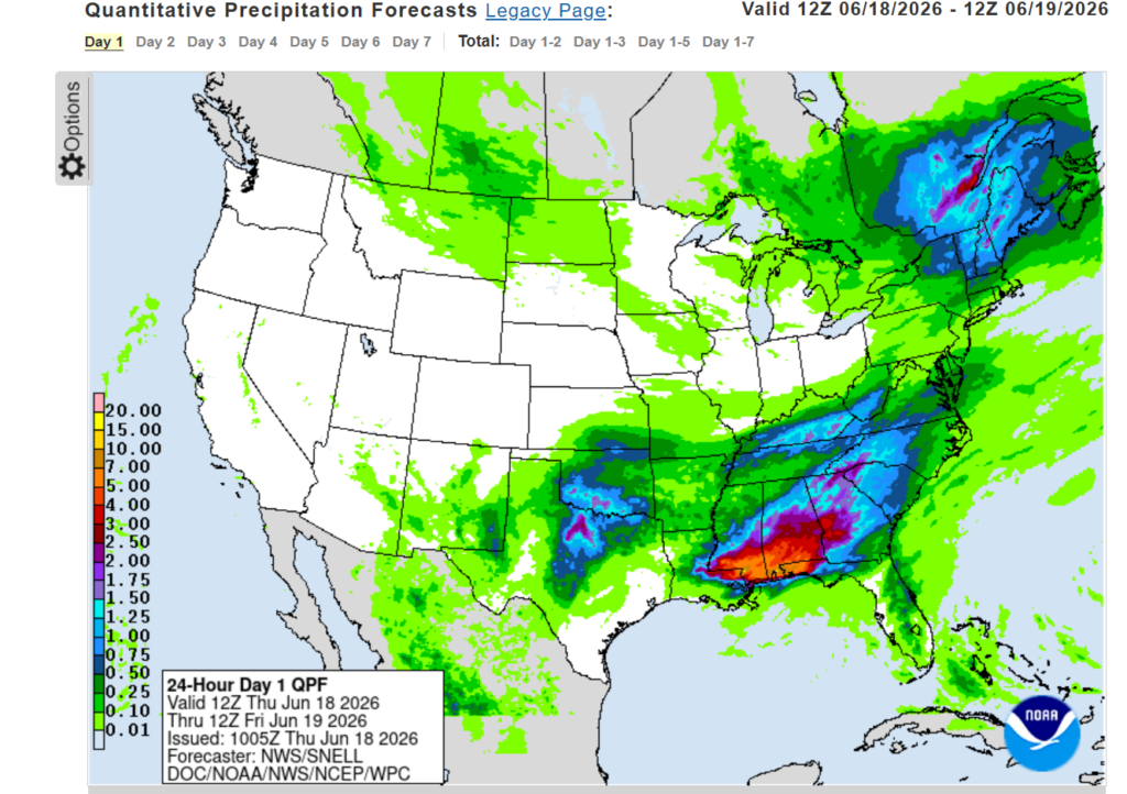
For today, the Weather Prediction Center has marked the Mississippi and Alabama gulf coasts under high risk of excessive rainfall, moderate for some of southeast Louisiana, southern Mississippi, much of Alabama, and parts of western Georgia. The QPF also points to the southern portions of the region getting heavy rainfall, several inches of rain can fall in a short period of time.
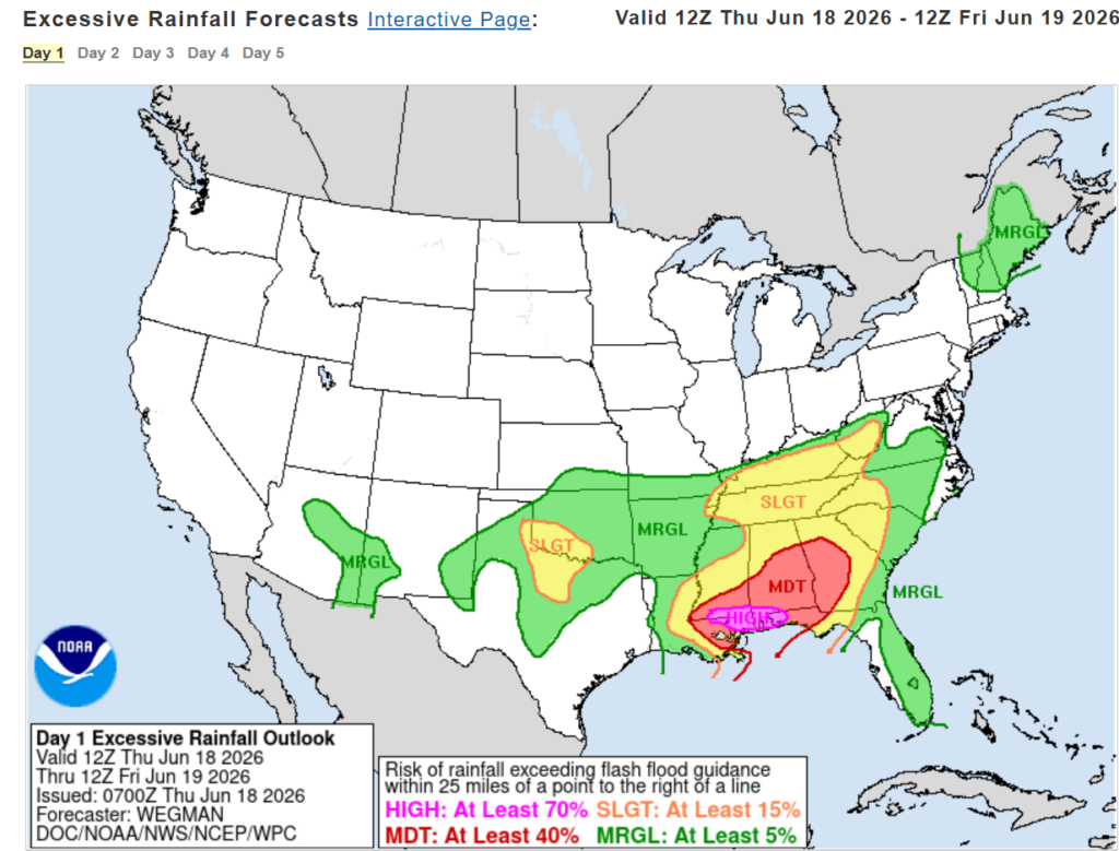
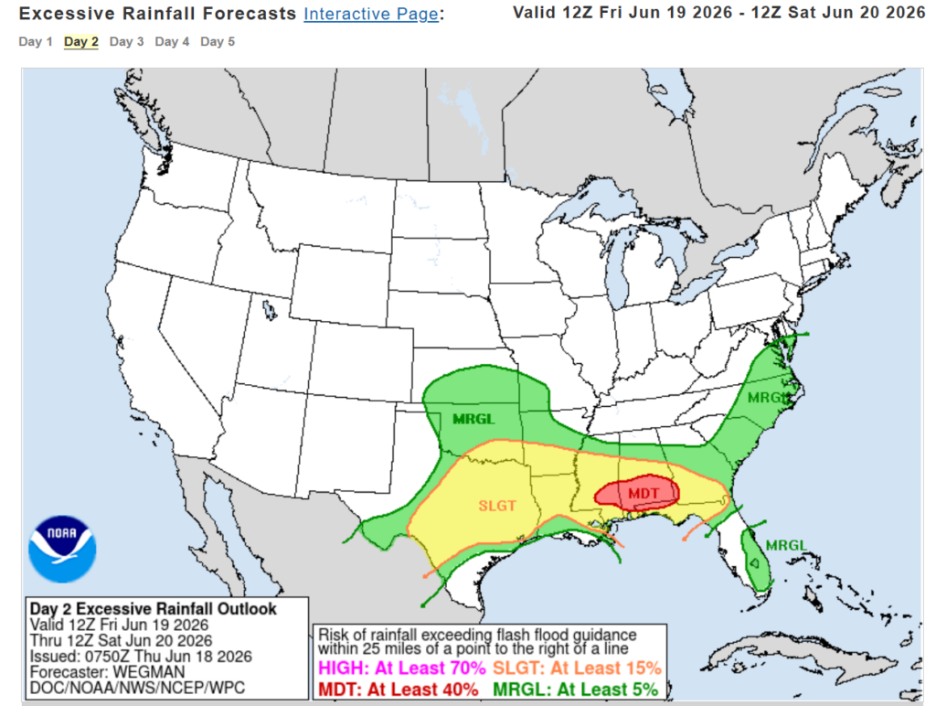
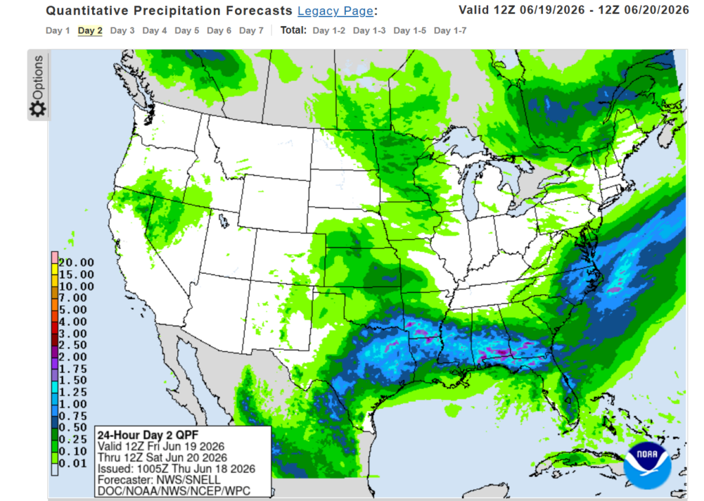
Tomorrow will still be important to look at as that deep tropical moisture will still be present, fueling rain and thunderstorms. The WPC has the area under moderate, slight, and marginal for excessive rainfall. Main areas of concern are southern Alabama and a little of Mississippi that are under moderate risk. Slight risk for a lot of the region, so do still take this seriously!
3-DAY TRAVEL FORECAST
AIRPORTS
KIAH/KHOU (Houston) – No weather-related delays are expected today or tomorrow. A slight chance of showers and thunderstorms after 1am tomorrow night and again Saturday afternoon could result in brief delays due to lightning.
KSHV (Shreveport) – A slight chance of showers and thunderstorms are possible today, but no major delays are expected. Chances of rain and thunderstorms increase Friday afternoon through Saturday night, delays due to lightning are possible.
KBTR (Baton Rouge) – Today through Saturday night, scattered showers and thunderstorms are possible. Being under a flood warning until Saturday night, heavy rainfall, lightning, and flooding concerns could cause delays.
KJAN (Jackson) – A period of unsettled weather is expected over the next few days with showers and thunderstorms producing heavy rainfall and lightning, so flight delays could be expected for today through Saturday night.
KMSY (New Orleans) – Scattered showers and thunderstorms for today, and strong wind gusts that could lead to delays from heavy rainfall and lightning. Intermittent delays are possible tomorrow and Saturday due to lightning.
KMOB (Mobile) – Flight delays and even cancellations are expected today as heavy rainfall, severe thunderstorms, and high winds are occurring. Delays can be expected tomorrow and Saturday with showers and thunderstorms producing heavy rain and lightning.
KATL (Atlanta) – Delays are possible today as a flood watch is in effect, showers and thunderstorms producing heavy rainfall and lightning. Scattered showers and thunderstorms for tomorrow and Saturday could potentially cause brief delays with lightning.
KTLH (Tallahassee) – Delays due to lightning and heavy rainfall are possible each day and night. Chances fall mainly in the afternoon, Friday having the greatest chance for delay.
KBHM (Birmingham) – A flood watch is in effect today and tomorrow, delays due to lightning and heavy rain could be expected in this time period. Delays also possible Saturday due to lightning.
HIGHWAYS
I-10 – Really not a good time to travel for the next few days. Heavy rainfall and flooding is possible and expected for this highway. Try to avoid driving on this highway, but if unavoidable, please be careful.
I-20 – Today and tomorrow are not the best days for driving, heavy rainfall for Mississippi and Louisiana is expected. Saturday, heavy rain is expected for Louisiana along I-20, Saturday afternoon for Mississippi. Drive carefully these next few days.
I-49 – Showers and thunderstorms possible throughout the day today and tomorrow for central Louisiana. Saturday, strong showers and thunderstorms are possible for all of Louisiana, so avoid driving down this highway if you can.
I-55 – Each day, showers and thunderstorms that will produce heavy rainfall are possible, so this is a period of time that is not the best for travelling. A brief quiet period is possible overnight tonight and really early Friday morning, but in general showers and thunderstorms will be occurring.
I-59 – Each day, showers and thunderstorms that will produce heavy rainfall are possible, so try to avoid travelling along this highway for the next few days. Highest amounts of rain are today, flooding is possible. Saturday would be the best travel day, but rain is still expected.
I-65 – Today through Saturday, heavy rain and thunderstorms are expected. Today, severe weather and thunderstorms capable of producing tornadoes are expected, so avoid travelling today if you can. That also includes tomorrow as roads will be wet. Saturday would be the best travel day, but rain is still expected.
I-75 – Today is generally good to travel, but this evening and overnight showers and thunderstorms will start to fire up in this area. This continues during the day Friday mainly in central/southern Georgia. Saturday will see rain, but it should be safer to travel. Overall, just drive safely these next few days.
In general, it is not a great time these next few days to travel anywhere. If you cannot avoid driving on any of these highways, drive safely and be careful!
CITY FORECASTS
Houston, TX
Today/Tonight – Houston is under an Extreme Heat Warning today, heat index values are as high as 114. If you are outside, take care of yourself! Mostly sunny skies with a high of 95. Not much relief tonight as the low will be near 81.
Tomorrow – Still under a heat advisory, the high will reach near 93, heat index values near 109. Again, take care of yourself! Partly sunny skies during the day, and a 30% chance at some showers and thunderstorms tomorrow night after 1am. The low will fall to 80.
Saturday – Slight chance of showers and thunderstorms Saturday afternoon at 30%, but other than that, partly sunny skies and a high in the lower 90s. The heat advisory will still be in effect. The low will fall in the upper 70s.
Shreveport, LA
Today/Tonight – Today will be mostly sunny with a high near 93 and heat index values near 106. There is a 20% chance of showers and thunderstorms for the morning/early afternoon. Make sure to take care of yourself today as there is a heat advisory!
Tomorrow – Chance of precipitation is 60% tomorrow, showers and thunderstorms likely in the afternoon. It will be mostly cloudy with a high of 90, heat index values as high as 103. The chance of precipitation continues into the late evening and tonight. The low will fall around 76.
Saturday – Chance of precipitation is 60% Saturday, mainly showers and a possible thunderstorm. The high will be in the upper 80s, the low falling in the mid 70s. Showers and thunderstorm chances will continue Saturday night.
Baton Rouge, LA
Today/Tonight – Baton Rouge is currently under a flood warning and watch until tonight. A 50% chance of showers and thunderstorms for today, the high is 90 and low is 79. Tonight, there is a slight chance of showers, but it does not continue overnight. A quarter to a half inch of rain is possible.
Tomorrow – The flood warning continues tomorrow. A 30% chance of showers and thunderstorms in the afternoon. Other than that, it will be mostly sunny with a high near 93. Heat index values could reach up to 106. The low will fall around 77, and chance of showers and thunderstorms will continue overnight.
Saturday – The flood warning continues into Saturday. Chance of precipitation is 60%, showers and thunderstorms are likely in the afternoon. The high will be in the lower 90s, and low will fall in the upper 70s. Chance of showers and thunderstorms continue overnight.
Jackson, MS
Today/Tonight – Today and tonight are under a flood watch. Chance of precipitation is 80%, with storms that can produce heavy rainfall. Wind gusts could reach up to 25 mph. Chances of precipitation continue overnight, thunderstorms producing heavier rainfall. The high will be 84, and low will fall to 74.
Tomorrow – Still under a flood watch, chance of precipitation is 80%. Half an inch of rain is possible, showers and thunderstorms mainly possible before 2pm. The high will be near 87, low falling to 73. Chance of showers and thunderstorms continue overnight, thunderstorms producing heavier rain.
Saturday – Chance of precipitation is 80%, mainly showers and possibly a thunderstorm. Between a quarter to half an inch of rain is possible. The high will fall in the upper 80s, low will be in the lower 70s. Chances of showers and thunderstorms continue overnight.
New Orleans, LA
Today/Tonight – A flood watch is in effect today. A 50% chance of showers and thunderstorms, wind gusts as high as 35 mph are possible. A tenth to a quarter inch of rain is expected, higher amounts in thunderstorms. The high will be around 90, low around 81. The heat index could be as high as 106 today. Chance of showers continues into the late evening.
Tomorrow – A heat advisory will be in effect tomorrow. A 20% chance of showers and thunderstorms for tomorrow afternoon. Other than that, mostly sunny skies and a high near 92. Heat index values can reach up to 107. Chance of showers and thunderstorms continues tomorrow night, low around 80.
Saturday – A 50% chance of showers and thunderstorms for Saturday. The high will fall near 90, and low in the upper 70s. Chance of precipitation continues overnight.
Mobile, AL
Today/Tonight – Today, a flood watch, tornado watch, and coastal flood advisory are in effect. With a 100% chance of precipitation, today severe thunderstorms are possible, and it is gusty, wind gusts up to 30 mph. Heavy rainfall is expected, amounts up to 4 inches is possible. The high is near 84, low falling to 77. These conditions will continue overnight, 2-3 inches of rain possible tonight.
Tomorrow – Still under the flood watch, showers and thunderstorms are likely in the afternoon. Chance of precipitation is 60%, the high will be near 90 and heat index values could reach 105. Up to an inch of rain is possible. The low will fall near 75, showers and thunderstorms continuing overnight.
Saturday – Chance of precipitation is 60%, showers and thunderstorms in the afternoon. The high will be near 90, and low in the mid 70s. Chance of showers and thunderstorms continues into Saturday night.
Atlanta, GA
Today/Tonight – Today and tonight have a flood watch in effect, and a wind advisory will come in effect tonight. Chance of precipitation is 80%, showers and thunderstorms possible throughout the day. Up to a half inch of rain is possible. Wind gusts up to 25mph are possible. The high will be 84, falling gradually throughout the day. The low will be 71. Showers and thunderstorms continue overnight, up to 1-2 inches of rain is possible. Wind gusts up to 30 mph for tonight.
Tomorrow – Flood watch continues through tomorrow night. Chance of precipitation is 30%, showers and thunderstorms throughout the day. The high will be near 85 and low falling to 68. Wind gusts up to 15 mph are possible. Showers and thunderstorms will continue into the late evening.
Saturday – 30% chance of showers and thunderstorms in the afternoon. The high will fall in the high 80s, low in the lower 70s. Showers and thunderstorms will continue overnight.
Tallahassee, FL
Today/Tonight – Chance of precipitation is 60%, showers and thunderstorms possible throughout the day and tonight. Wind gusts could reach as high as 30 mph. The high will be near 90, low around 79. High rainfall amounts are expected in thunderstorms.
Tomorrow – Chance of precipitation is 80%, showers and thunderstorms in the afternoon. Wind gusts could reach as high as 25 mph. Between 1-2 inches of rain is possible. The high will be around 90, heat index values reaching 100. The low will fall around 76, showers and thunderstorms continuing overnight.
Saturday – Chance of precipitation is 90%, showers and thunderstorms in the afternoon and evening. The high will fall in the lower 90s, the low in the mid 70s. Gusty winds are still expected.
Birmingham, AL
Today/Tonight – A flash flood warning is in effect until 12:45 pm, and a flood watch is in effect today and tonight. Chance of precipitation is 100%, heavy rain from showers and thunderstorms. The high is near 80, low around 70. Showers and thunderstorms will continue overnight, up to an inch of rain is possible.
Tomorrow – Still under a flood watch, chance of precipitation is 30%, which will continue overnight. The high will fall around 85, low around 69.
Saturday – A 50% chance of showers and thunderstorms for Saturday. The high will fall in the upper 80s and the low in the lower 70s. Showers and thunderstorms will continue Saturday night.


