Hello everyone and happy Sunday! For the weather over the next 3-days, we can expect much of the southeast to see rainfall, as well as below normal temperatures due to the increased cloud cover associated with the rainfall. First, we will take a look at the synoptic pattern, and then take a look at how this will influence rainfall and temperatures.

If we take a look at the 500MB heights and vorticity for today, we can see a frontal system making its way across the southeast, resulting in heavy rain for portions of Texas, Louisiana, Arkansas, and Oklahoma. In fact, the WPC has this area marked for excessive rainfall for the day today.

According to the WPC, the area with greatest chance of flooding would be along the Texas and Oklahoma border, with at least a 40% chance of excessive rainfall, thanks to the positive vorticity advection assisting with lift and leading to heavier amounts of precipitation.
If we take a look at the precipitable water values across the southeast, we can see where all this moisture resides.
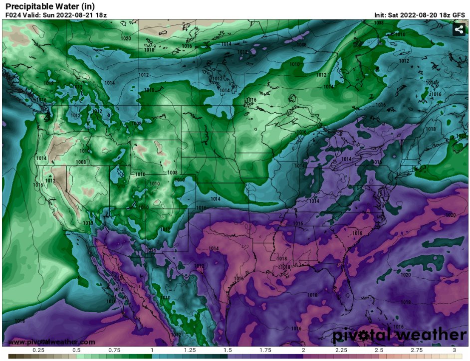
Looking at the map, all of the southeast is above 2″ with many locations even coming closer to 2.25″. This makes for a very moist airmass, with any rainfall likely to be heavy when we get the right conditions for precipitation.
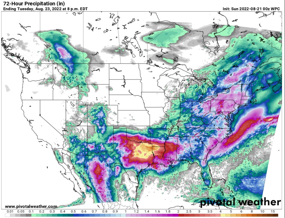
If we take a look at the 3-day precipitation forecast across the southeast, we can see the heaviest precipitation will fall across portions of northeast Texas and into Louisiana, approaching 4″+. This can be attributed to the frontal system which will move through the area, combined with the very moist tropical airmass providing plenty of moisture for heavy rainfall. Due to this, it is important to continue to monitor your local forecast office for any flood advisories and or warnings, as such high amounts of rainfall in a short period of time could lead to flash flooding.

As for temperatures, below average will be normal over the next couple of days, with the rainfall holding temperatures back.
3-Day Southeast City Forecast
| Dallas, TX | ||
| Sunday | Monday | Tuesday |
| High: 88 | High: 81 | High: 83 |
| Low: 74 | Low: 73 | Low: 72 |
| Precip: 90% | Precip: 80% | Precip: 60% |
| Houston, TX | ||
| Sunday | Monday | Tuesday |
| High: 90 | High: 91 | High: 88 |
| Low: 78 | Low: 77 | Low: 76 |
| Precip: 60% | Precip: 70% | Precip: 80% |
| New Orleans, LA | ||
| Sunday | Monday | Tuesday |
| High: 88 | High: 86 | High: 83 |
| Low: 77 | Low: 76 | Low: 76 |
| Precip: 70% | Precip: 80% | Precip: 80% |
| Little Rock, AR | ||
| Sunday | Monday | Tuesday |
| High: 86 | High: 83 | High: 86 |
| Low: 71 | Low: 70 | Low: 69 |
| Precip: 60% | Precip: 50% | Precip: 40% |
| Memphis, TN | ||
| Sunday | Monday | Tuesday |
| High: 86 | High: 86 | High: 89 |
| Low: 71 | Low: 69 | Low: 69 |
| Precip: 50% | Precip: 30% | Precip: 30% |
| Birmingham, AL | ||
| Sunday | Monday | Tuesday |
| High: 85 | High: 80 | High: 85 |
| Low: 71 | Low: 69 | Low: 68 |
| Precip: 80% | Precip: 70% | Precip: 40% |
| Atlanta, GA | ||
| Sunday | Monday | Tuesday |
| High: 84 | High: 81 | High: 84 |
| Low: 69 | Low: 67 | Low: 67 |
| Precip: 90% | Precip: 60% | Precip: 40% |


