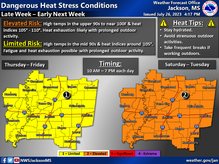
Heat is staying in the South while we experience some drier air for the next week. We are seeing some heat warnings for much of our area with a limited risk today into tomorrow and an elevated risk this weekend into next week. This means high heat indices and that it is very important to stay hydrated and avoid being outside for large periods of time. Let’s see how long this pattern will last!
[wpcode id=”41149″]
Hot and Dry Staying for a While
Heat is coming back strong to the area this week into next week. Temperatures will increase throughout the day and highs will reach temperatures close to the 100s or above in most areas. Heat warnings have been in effect for the weekend. This heat will have heat indices in the 105-110 range which means the feeling of heat will be strong. The only possibility of some cool down is from the Gulf shore winds along the coast.
As for wet weather we should see a dry pattern spread across the region due to a high pressure system settling over the area. This will bring clear weather and lots of sun which also contributes to the increase in heat. However the one possibly helpful bit is the dry air that will make the temperatures feel more exact with the lack of moisture outside of being in the direct sun. This area will remain dry although some scattered afternoon showers is possible but not very likely due to the extremely dry nature of the air.
[wpcode id=”41149″]
Extended Outlook
Looking ahead this region will stay pretty hot and dry with occasional afternoon thunderstorms possible throughout the area. Humidity will be very high in the area as some moisture comes off the Gulf of Mexico which leads to some thunderstorms especially along the coast. We will be drier than normal for the beginning of August as well as hotter than normal. Heat will linger with temperatures saying in the upper 90s and low 100s. The heat indices will be very high so it will be crucial to remain safe outdoors and hydrated.
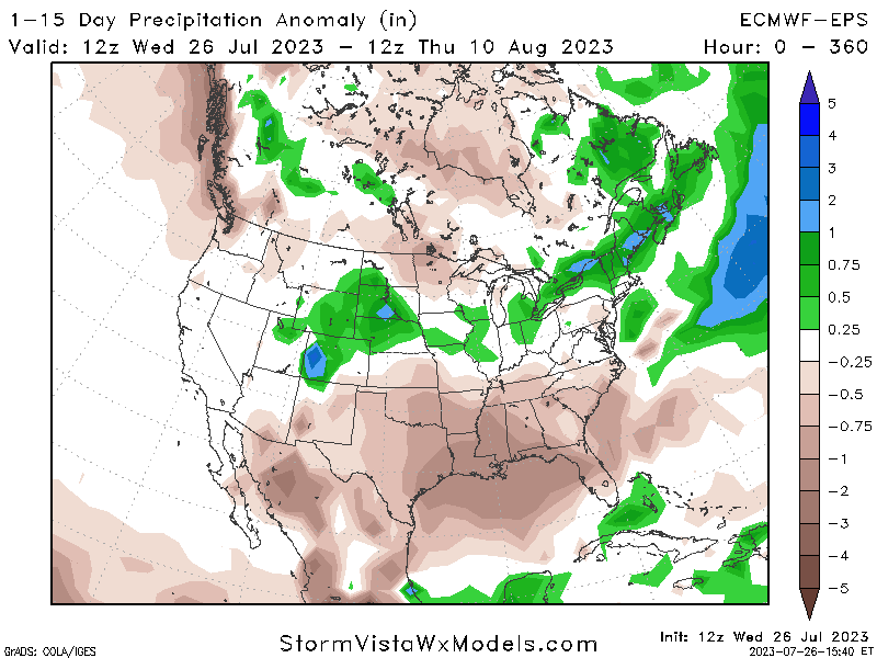
Precipitation Anomaly for 1-15 Days 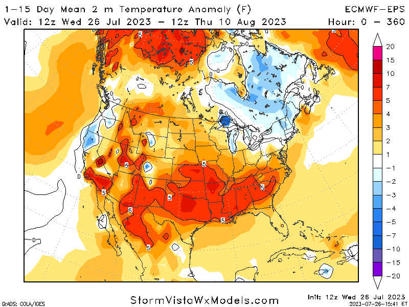
Temperature Anomaly for 1-15 Days
[wpcode id=”41149″]
Regional Day-To-Day Forecast
Today: Sunny. High temperatures in the upper 90s to low 100s. Winds west southeast around 5 mph.
Tonight: Partly cloudy. Low temperatures in the upper 70s to low 80s. Winds south around 5 mph.
Friday: Sunny. High temperatures in the upper 90s to low 100s. Winds east southeast around 5 mph.
Friday Night: Mostly clear. Low temperatures in the upper 70s to low 80s. Winds south around 5 mph.
Saturday: Sunny. High temperatures in the upper 90s to low 100s. Winds west around 5 mph.
Saturday Night: Mostly clear. Low temperatures in the low to mid 70s. Winds southwest around 5 mph.
Sunday: Sunny. High temperatures in the upper 90s to low 100s. Winds southwest 5 to 10 mph.
Sunday Night: Mostly clear. Low temperatures in the low to mid 70s. Winds south 5 to 10 mph.
Monday: Sunny. High temperatures in the upper 90s to low 100s. Winds west 5 to 10 mph.
Monday Night: Mostly clear. Low temperatures in the low to mid 70s. Winds east 5 to 10 mph.
Tuesday: Sunny. High temperatures in the upper 90s to low 100s. Winds west 5 to 10 mph.
Tuesday Night: Mostly clear. Low temperatures in the upper 70s to low 80s. Winds south 5 to 10 mph.
Wednesday: Sunny. High temperatures in the upper 90s to low 100s. Winds southwest 5 to 10 mph.


