Soak up the sun while you can, as this week has hotter temperatures and fewer storms in store! The overall chance for rain will decrease this week, though afternoon sea breeze storms along the coast will still be possible. If you’re outside catching some rays, keep water handy, as a dangerous combination of heat and humidity will make it feel more like 100-105°F.
Ridging in the upper levels of the atmosphere is limiting storm development, allowing summer-like conditions to stick around throughout the week.
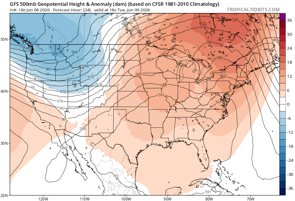
As the week goes on, forecast guidance shows the ridge beginning to break down, allowing rain chances to gradually increase heading into the weekend.
By Friday and Saturday, a nearby cold front will bring a better chance for showers and thunderstorms across northern Alabama and Mississippi. Farther south, sinking air associated with high pressure should keep most southern locations relatively dry, though an isolated shower or storm can’t be ruled out.
Early next week, things change as an upper-level trough makes its presence well known. Bringing with it the return of severe weather and the possibility of a mesoscale convective system (MCS), a large complex of thunderstorms.
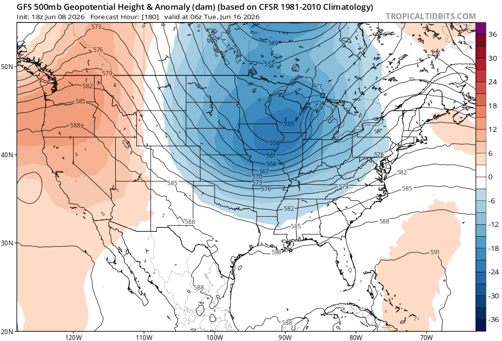
Long range guidance shows a low-pressure system and cold front moving across the northern Gulf Coast states next week. While we are still about a week out and details remain fuzzy, there is still potential for stronger storms, so it remains something to monitor. In the meantime, enjoy the heat and sunshine!
3-DAY TRAVEL FORECAST
AIRPORTS
KIAH / KHOU (Houston) – Chance for scattered storms Tuesday between 1-4pm. Chance for scattered storms Wednesday afternoon and evening. Intermittent weather delays possible for some flights due to lightning
KSHV (Shreveport) – Heat index values as high as 105, aside from that, no weather-related issues anticipated through Wednesday.
KBTR (Baton Rouge) – Hit and miss evening storms possible each day. Be prepared for brief rounds of heavy rain, lightning and gusty wind. Intermittent flight delays possible for each.
KMSY (New Orleans) – Low chance of scattered storms Tuesday evening, aside from that, no weather-related issues anticipated through Wednesday.
KJAN (Jackson) – No weather-related issues anticipated through Wednesday.
KMOB (Mobile) – Patchy fog each day between 3-7am, aside from that, no weather-related issues anticipated through Wednesday.
KBMH (Birmingham) – A chance of showers and thunderstorms tonight. Low-end chance for thunderstorms Tuesday in the afternoon and evening hours. Be prepared for brief rounds of heavy rain, lightning and gusty wind. Intermittent flight delays possible for each.
KTLH (Tallahassee) – Chance for evening thunderstorms possible each day. Be prepared for brief rounds of heavy rain, lightning and gusty wind. Intermittent flight delays possible for each.
KATL (Atlanta) – A chance of showers and thunderstorms before midnight tonight. Tuesday is the highest impact day with likely thunderstorms, mainly between 2pm and 5pm, bringing heavy rain, lightning, and possible travel delays. Wednesday is much quieter with only a slight chance of a brief afternoon storm
HIGHWAYS
I-10
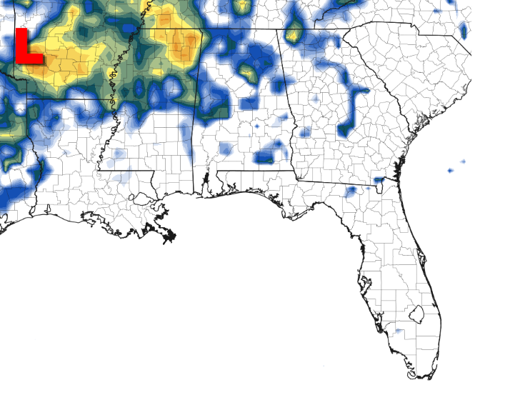
Scattered showers and thunderstorms are expected tonight, with the most activity focused across southern Mississippi and Louisiana. By Tuesday evening, heavier rainfall is expected to move into the Florida Panhandle and continue into the overnight hours. Be prepared for brief rounds of heavy rain, lightning and gusty wind.
I-20
Showers and storms continue tonight with a flash flood risk on roads near Birmingham. A brief dry slot follows, then scattered storms return Tuesday evening near Birmingham and Atlanta.
I-49
Tuesday evening brings hit-or-miss storms across southern Louisiana, with ponding possible on roadways. Heat index values will climb as high as 103°F Tuesday afternoon.
I-55 & I-59
Scattered showers are expected tonight near Jackson and LaPlace, otherwise conditions remain mostly dry through Wednesday.
I-65
Flood warnings are in place tonight across northern Alabama, with flooded roadways possible. Scattered showers will diminish overnight. Tuesday evening, scattered storms could bring heavy rainfall.
I-75
Flood watch remains in effect as locally heavy rainfall and training thunderstorms continue to pose a flood risk. Flash flooding is ongoing south of Macon. Showers will continue overnight tonight. On Tuesday, scattered showers are expected mainly between 9 AM and 4 PM, with ponding on roadways possible.Wednesday looks mostly dry.
CITY FORECASTS
Houston, TX
Tonight – Partly cloudy, with a low around 77. Southeast wind 5 to 10 mph.
Tuesday– Low-end chance of showers and thunderstorms after 1pm. Otherwise, mostly sunny, with a high near 90. Southeast wind 5 to 10 mph.
Wednesday– A slight chance of showers, with thunderstorms also possible after 10am. Mostly sunny, with a high near 90. South wind 5 to 10 mph, with gusts as high as 20 mph.
Shreveport, LA
Tonight – A 20 percent chance of showers and thunderstorms before 10pm. Mostly clear, with a low around 76. South wind 5 to 10 mph.
Tuesday– Mostly sunny and very hot, with a high near 95. Heat index values as high as 102. South wind around 5 mph. Drink water!
Wednesday– Mostly sunny and very hot, with a high near 95. Heat index values as high as 105. South wind 5 to 10 mph. Drink water!
Baton Rouge, LA
Tonight – Mostly cloudy, then gradually becoming mostly clear, with a low around 75. Southeast wind around 5 mph becoming calm in the evening.
Tuesday– Low-end chance of showers and thunderstorms after 1pm. Mostly sunny, with a high near 91. Southeast wind around 5 mph.
Wednesday– A 20 percent chance of showers and thunderstorms after 1pm. Sunny, with a high near 91. South wind around 5 mph.
New Orleans, LA
Tonight – Mostly cloudy, with a low around 77. Southeast wind around 5 mph.
Tuesday– Low-end chance of showers and thunderstorms after 1pm. Otherwise, mostly sunny, with a high near 88. Southeast wind 5 to 10 mph.
Wednesday– Sunny, with a high near 89. Southeast wind 5 to 10 mph.
Jackson, MS
Tonight – Mostly clear, with a low around 73. South southeast wind around 5 mph becoming calm in the evening.
Tuesday– Sunny and very hot with a high near 93. Heat index values as high as 98. Light southerly wind.
Wednesday– Sunny and very hot with a high near 93. Heat index values as high as 99. Light southerly wind.
Birmingham, AL
Tonight – A chance of showers and thunderstorms overnight. Otherwise, mostly cloudy, with a low around 71. Calm wind.
Tuesday– A slight chance of showers, with thunderstorms also possible after 10am. Partly sunny, with a high near 90. Calm wind becoming south around 5 mph in the afternoon.
Wednesday– Sunny, with a high near 90. Light southwesterly wind.
Mobile, AL
Tonight – Patchy fog after 3am. Otherwise, mostly cloudy, with a low around 75. Light southerly wind.
Tuesday– Patchy fog before 7am. Otherwise, mostly cloudy, then gradually becoming sunny, with a high near 91. Light and variable wind becoming south 5 to 10 mph in the afternoon.
Wednesday– Patchy fog before 7am. Otherwise, mostly cloudy through mid morning, then gradual clearing, with a high near 91. Light and variable wind becoming south 5 to 10 mph in the afternoon.
Tallahassee, FL
Tonight – Mostly cloudy, with a low around 75. Calm wind.
Tuesday– Low-end chance of showers and thunderstorms after 3pm. Mostly cloudy, with a high near 89. Light easterly wind.
Wednesday– A 40 percent chance of showers and thunderstorms after 2pm. Mostly sunny, with a high near 93. Light wind blowing from the southeast.
Atlanta, GA
Tonight – A chance of showers and thunderstorms overnight. Otherwise, mostly cloudy, with a low around 69. Calm wind.
Tuesday– Showers and thunderstorms likely, mainly between 2pm and 5pm. High near 84. Watch for flooding and ponding on roadways.
Wednesday– Low-end chance of showers/thunderstorms in the afternoon. Otherwise, mostly sunny, with a high near 88. Light southwesterly wind.


