Okay, you guys win! It’s going to be a “hot” day, today. Temperatures around 90F with this much humidity, I suppose, should be considered “hot” weather. Not much of a shot for rain today. That said, I didn’t think we would see much rain yesterday, and many folks ended up with a brief cooling rain shower around midday and into the afternoon.


So, maybe we will get lucky and see some brief rain again today.
The one thing that may help it feel slightly cooler is the breeze. It’ll be a south wind, so it’ll still be a warm and muggy breeze. But at least the air is moving!
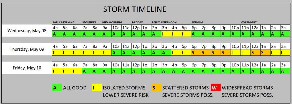
We will play the same game again on Thursday – with a shot for some storms, too.
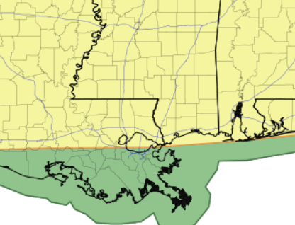
The Storm Prediction Center has highlighted a majority of the are with a Slight Risk for severe weather. The main concern looks to be heavy rain, lightning, wind gusts up to 65mph, and hail. The tornado threat looks to be pretty low.
And, looking things over this morning, we may get two rounds. One in the morning (the leftovers from stuff to the north tonight) and then another round in the afternoon and evening (storms blowing through from Texas and Louisiana).
The Storm Timeline below probably looks a it more ominous thant he weather will be. I think most folks will probably be more “dry” than “rain-soaked” during the next 48 hours, but we will hold on to a shot for a few isolated storms here and there for a good chunk of time during the next few days.
After all of this blow through, a high-pressure system will ensure quieter weather with temperatures below average for the weekend. By Monday, there may be another change, with a shot for rain increasing again due to a new low-pressure system developing in the Central Plains.
REGIONAL DAY TO DAY FORECAST
Today: Mostly cloudy this morning, then becoming mostly sunny. Highs around 90. South winds 10 to 15 mph. Gusts up to 30 mph this afternoon.
Tonight: Mostly cloudy. Lows in the lower 70s. South winds 10 to 15 mph with gusts up to 25 mph.
Thursday: Mostly cloudy in the morning, then partly sunny with a slight chance of showers and thunderstorms in the afternoon. Humid with highs around 90. South winds 10 to 15 mph. Chance of rain 20 percent.
Thursday Night: Mostly cloudy with a chance of thunderstorms. A chance of showers in the evening, then showers likely after midnight. Lows in the upper 60s. Southwest winds 5 to 10 mph. Chance of rain 60 percent.
Friday: Partly sunny. A chance of showers and thunderstorms in the morning. Highs in the mid 80s. Northwest winds 10 to 15 mph with gusts up to 25 mph. Chance of rain 50 percent.
Friday Night: Mostly clear. Cooler with lows in the upper 50s.
Saturday: Mostly sunny. Highs in the lower 80s.
Saturday Night: Mostly clear in the evening, then becoming mostly cloudy. Lows in the upper 50s.
Sunday: Partly sunny in the morning, then becoming mostly cloudy. Highs in the lower 80s.
Sunday Night: Mostly cloudy. A chance of showers and thunderstorms after midnight. Lows in the lower 60s. Chance of rain 30 percent.
Monday: Showers likely with a chance of thunderstorms. Highs in the upper 70s. Chance of rain 30 percent.
Monday Night: Mostly cloudy. A slight chance of showers and thunderstorms in the evening, then a chance of showers and thunderstorms after midnight. Lows in the mid 60s. Chance of rain 20 percent.
Tuesday: Showers likely with a chance of thunderstorms. Highs in the lower 80s. Chance of rain 20 percent.


