Quite a bit of persistence, as is per usual at this stage of the summer here in the Southeast. High pressure continues to sit over the southern US states and keeps our lingering heat around virtually every day over the next 7 days. Dew point temperatures in the upper 60s to mid 70s paired with air temperatures in the upper 90s to low 100s will continue to bring near oppressive conditions across the region, with heat indices regularly clearing 105°F and reaching possibly 110°F or higher in some places.
This type of heat is definitely not one to be messed around with, and proper precautions to protect yourself from heat-related illnesses should be taken. Fortunately (or unfortunately depending on the timing), the chance for scattered showers and thunderstorms will exist virtually every day across the majority of our region.
[wpcode id=”41149″]
Short-Term Outlook
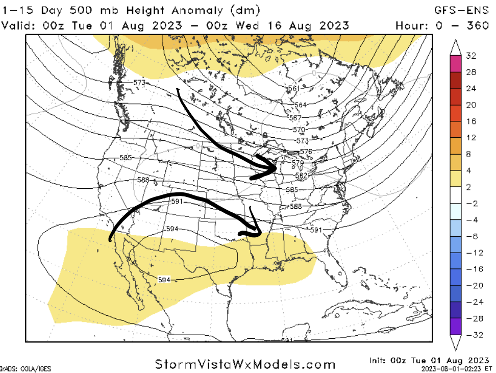
The main story in the immediate future and the down the road by far will be the heat. As previously mentioned, high pressure sitting over us will keep us very much baking in heat. Continued streaming of rich Gulf moisture into the area will keep us very much uncomfortable as it interacts with regular air temperatures in the upper 90s to low 100s. Excessive Heat Warnings are in effect until 8pm today, minus those in southern Alabama and southwest Mississippi, and further advisories and warnings will undoubtedly be needed over the coming days in response to heat indices potentially clearing 110°F.
Daily pulse storms resulting from the diurnal heating cycle will also be possible each day, but it is difficult to say specifically who is going to get rain or not. Overall, chances for showers and thunderstorms will exist across the region in some capacity daily.
There is a substantial opportunity for thunderstorms though on Thursday, as a surface low and warm front will help to pull moisture up from the Gulf and establish an unstable atmosphere for storms across portions of eastern Mississippi and southern Alabama. An incoming MCS from the north will move through in the evening to overnight hours will interact with this unstable airmass in place and may have the potential to produce damaging winds with the presence of modest vertical wind shear, moderate DCAPE values approaching 1000 J/kg, and strong moisture convergence. The best chances for these thunderstorms will be from 4-10pm.
[wpcode id=”41149″]
Extended Outlook
Not much is looking to change until we get to the weekend and early next week. The upper-level high will start to break down and retreat westward, allowing for more zonal to northwesterly flow to overspread the area. This would translate into greater opportunities for synoptic to mesoscale disturbances to move into our area.
Temperatures however, unless we get a cold front to punch out this heat and cool us down even temporarily, will still remain close to what it will be over the next few days.
[wpcode id=”41149″]
REGIONAL DAY-TO-DAY FORECAST
Tuesday: Partly cloudy skies and hot, with a stray shower or thunderstorm possible. High temperatures in the upper 90s to low 100s. Heat indices may reach up to 110°F. Chance of rain 20%.
Tuesday night: Partly cloudy skies. Low temperatures in the upper 70s.
Wednesday: Partly cloudy skies and hot, with a stray shower or thunderstorm possible. High temperatures in the upper 90s to low 100s. Heat indices may reach up to 110°F. Chance of rain 20%.
Wednesday night: Mostly clear skies. Low temperatures in the upper 70s to low 80s.
Thursday: Partly cloudy skies and hot, with showers and thunderstorms likely. High temperatures in the upper 90s to low 100s. Heat indices may reach up to 110°F. Chance of rain 60%.
Thursday night: Mostly cloudy skies, with a chance of showers and thunderstorms. Low temperatures in the upper 70s to low 80s. Chance of rain 30%.
Friday: Mostly cloudy skies and hot, with a chance of showers and thunderstorms. High temperatures in the upper 90s to low 100s. Heat indices may reach up to 110°F. Chance of rain 30%.
Friday night: Partly cloudy skies, with a stray shower or thunderstorm possible. Low temperatures in the upper 70s to low 80s. Chance of rain 20%.
Saturday: Mostly sunny skies and hot, with a chance of showers and thunderstorms. High temperatures in the upper 90s. Heat indices may reach up to 110°F. Chance of rain 30%.
Saturday night: Partly cloudy skies, with a stray shower or thunderstorm possible. Low temperatures in the upper 70s to low 80s, Chance of rain 20%.
Sunday: Mostly sunny skies and hot, with a stray shower or thunderstorm possible. High temperatures in the upper 90s to low 100s. Chance of rain 20%.
Sunday night: Mostly clear skies. Low temperatures in the upper 70s to low 80s.
Monday: Mostly sunny skies and hot. High temperatures in the upper 90s to low 100s.
Monday night: Partly cloudy skies, with a stray shower or thunderstorm possible. Low temperatures in the upper 70s to low 80s. Chance of rain 20%.


