Howdy!
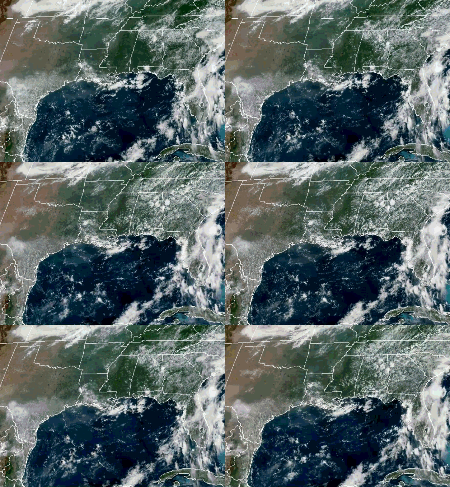
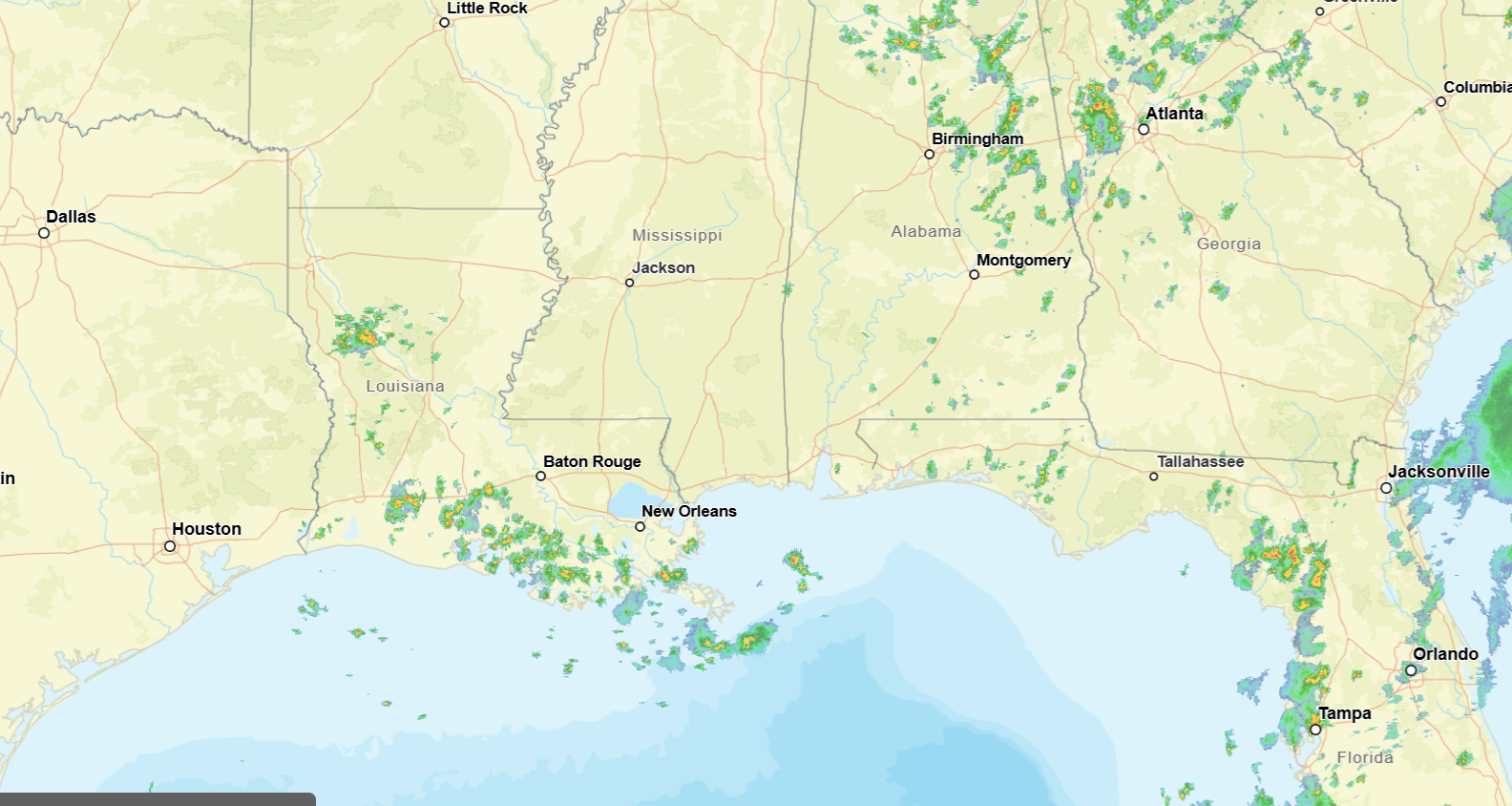
Looking out the window at around 12:15pm CST, there is some cloud coverge over the region and some scattered showers and thunderstorms over southern/central Louisiana to begin the afternoon. Also, showers in northern Alabama and Georgia near Atlanta.
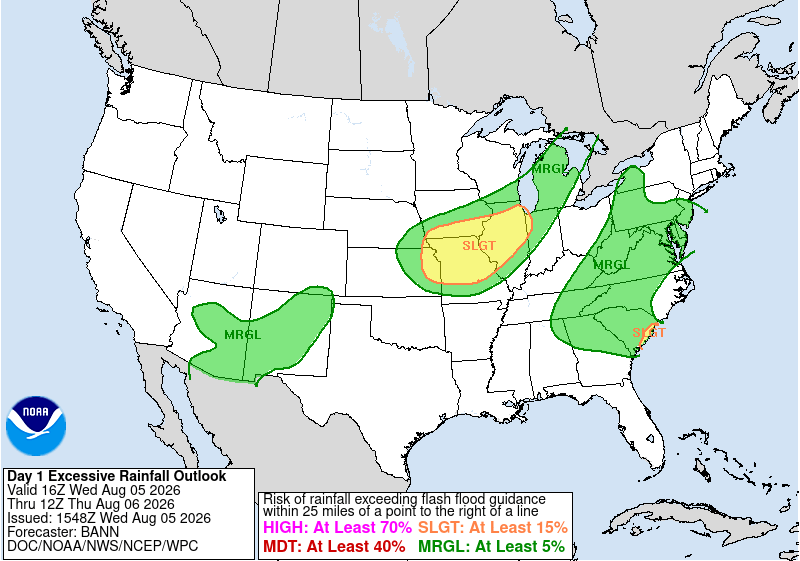
Northern Georgia and a bit of Alabama are seeing a marginal risk for excessive rainfall today, flooding not entirely ruled out for these areas of the region, so make sure to keep this in mind today!
The upper-level low that is currently situated over northern Georgia will be moving northward out of the region, leaving us under a weaker flow due to the subtropical high to the east and the ridge to the west, south/southeasterly flow will start to establish itself. By tomorrow into the weekend, the subtropical high will start to expand a bit into the area, allowing more moisture and southerly flow for the region.
This flow might allow a sea breeze to flow more inland, triggering showers and thunderstorms along it and increase the moisture in the low-levels. Isolated to scattered showers and thunderstorms are possible each afternoon as moisture starts to creep back in by later today into tomorrow. Humidity levels will also start to increase once again, increasing heat index values to above 100 for the region.
The plume of moisture we are going to get will stick around, fueling showers and thunderstorms into the weekend and next week.
The Climate Prediction Center predicts our region for next week and the week after to be below average/near average for precipitation, and above normal temperatures.
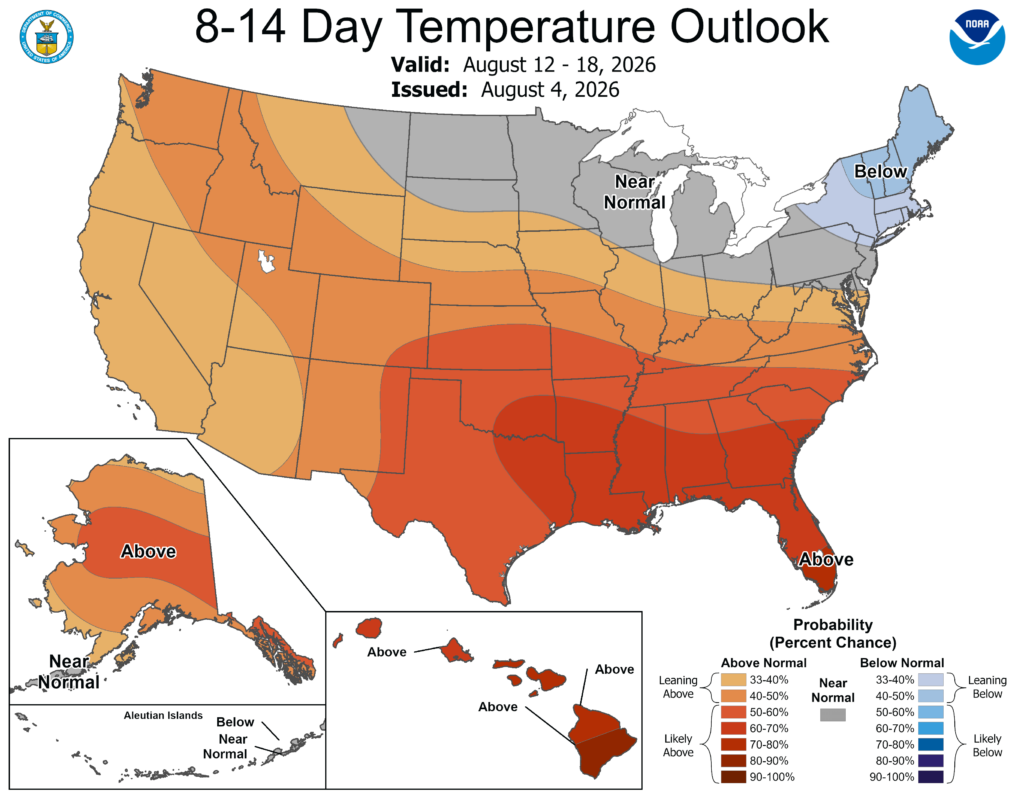
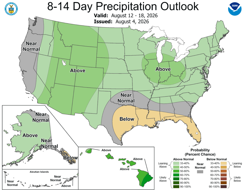
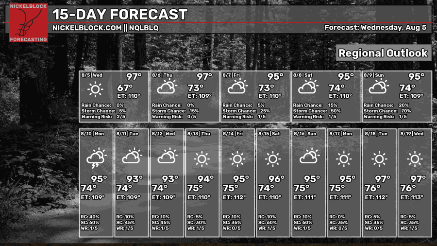
This could mean some hot, unpleasent conditions in the near future. Temperatures will remain in the 90s, humidity levels keeping the lows in the low to mid 70s for the most part.
3-DAY TRAVEL FORECAST
AIRPORTS
KIAH/KHOU (Houston) – No weather-related delays are anticipated. A slight chance for thunderstorms exists each day, but nothing significant enough for delays.
KSHV (Shreveport) – No weather-related delays are anticipated. A slight chance for thunderstorms exists today and tomorrow, but nothing significant enough for delays.
KBTR (Baton Rouge) – A chance for showers and thunderstorms exists today and tomorrow, greatest chance of brief delays being tomorrow night.
KJAN (Jackson) – No weather-related delays are anticipated.
KMSY (New Orleans) – A chance for showers and thunderstorms exists each day, the greatest chance of delays due to lightning being Thursday.
KMOB (Mobile) – No weather-related delays are anticipated. A slight chance for thunderstorms exists each day, but nothing significant enough for delays.
KATL (Atlanta) – Delays due to lightning are possible each day and night, the greatest chance of delays being this afternoon.
KTLH (Tallahassee) – A chance for showers and thunderstorms exists each day, the greatest chance of delays due to lightning being Thursday.
KBHM (Birmingham) – A chance for showers and thunderstorms exists each day, but nothing significant enough to cause major delays.
HIGHWAYS
I-10 – Scattered showers and thunderstorms are possible each day, mainly in the afternoon. Some of these storms could produce locally strong wind gusts, heavy rain, and frequent lightning. If traveling in the afternoon along I-10, be cautious of this.
I-20 – Scattered showers and thunderstorms are possible each day, mainly in the afternoon. If storms do occur along I-20, the stronger storms could produce heavier winds and rain.
I-49 – Scattered showers and thunderstorms are possible each day, the greatest chance of stronger storms in the afternoon. If traveling on this highway, pay attention to where these cells will be.
I-55 – Today is a better day for traveling on this highway, at most some isolated showers and thunderstorms when you get closer to the gulf coast. Tomorrow and Friday, scattered showers and thunderstorms in the afternoon will be impacting the area.
I-59 – Isolated to scattered showers and thunderstorms are possible each afternoon, coverage growing larger tomorrow and Friday. Some stronger storms could produce locally strong wind gusts and heavy rain, so be cautious of this.
I-65 – Scattered showers and thunderstorms are possible each day, the greatest chance of stronger storms in the afternoon, especially areas closer to the gulf coast. Stronger storms could produce strong wind gusts, heavy rain, and frequent lightning.
I-75 – Scattered to numerous showers and thunderstorms are possible each day, today having the greatest risk to see much stronger storms, especially in the northern portions of Georgia. If traveling over the next few days in the afternoon, be cautious and check the weather before leaving.
CITY FORECASTS
Houston, TX
Today/tonight – A 20% chance of showers and thunderstorms in the afternoon. Other than that, sunny and hot conditions with a high of 98 and heat index values as high as 106. Tonight, a 20% chance of showers and thunderstorms early on. Mostly clear conditions and a low around 79.
Tomorrow – A 20% chance of showers and thunderstorms in the afternoon. Some fog is possible in the early morning. Sunny skies and a high near 97, with heat index values as high as 104. Tomorrow night, mostly clear skies with a low around 78.
Friday – A 30% chance of showers and thunderstorms in the afternoon. Mostly sunny skies with a high around 96. The low will fall around 78 with mostly clear skies for the night.
Shreveport, LA
Today/tonight – A 20% chance of showers and thunderstorms in the afternoon. Other than that, mostly sunny and hot conditions with a high near 98, heat index values as high as 105. Tonight, mostly clear and a low around 77.
Tomorrow – A 20% chance of showers and thunderstorms in the afternoon. Mostly sunny and hot conditions with a high near 95 and heat index values as high as 104.
Friday – Sunny and hot, a high near 95 and a low around 76. Mostly clear skies at night.
Baton Rouge, LA
Today/tonight – A 40% chance of showers and thunderstorms for the afternoon. Other than that, sunny conditions and a high near 94. Tonight, a 20% chance of precipitation before 8pm, a low around 75.
Tomorrow – A 40% chance of showers and thunderstorms in the afternoon. Other than that, mostly sunny and a high near 94. Tomorrow night, a 60% chance of showers and thunderstorms mainly in the late afternoon. The low will fall around 75.
Friday – Sunny and hot conditions with a high near 95. Mostly clear with a low around 75 for Friday night.
Jackson, MS
Today/tonight – Sunny with a nigh near 96. Tonight, mostly clear conditions with a low around 72.
Tomorrow – A 20% chance of showers and thunderstorms in the afternoon. Some patchy fog in the early morning is possible. Other than that, mostly sunny skies and a high near 96, with heat index values as high as 102. Tomorrow night, mostly clear and a low around 73.
Friday – Some fog is possible in the early morning. After that, sunny skies with a high near 96. At night, mostly clear with a low around 74.
New Orleans, LA
Today/tonight – A 30% chance of showers and thunderstorms in the afternoon. Other than that, sunny conditions and a high near 93. Tonight, mostly clear with a low around 77.
Tomorrow – A 50% chance of showers and thunderstorms in the afternoon. The high will be around 92. Tomorrow night, mostly clear and a low around 77.
Friday – A 20% chance of showers and thunderstorms in the afternoon. Other than that, sunny skies with a high near 93. At night, mostly clear with a low around 78.
Mobile, AL
Today/tonight – A 20% chance of showers and thunderstorms in the afternoon. Sunny skies with a high near 93. Tonight, mostly clear with a low around 74.
Tomorrow – A 30% chance of showers and thunderstorms for the day. Other than that, mostly sunny and a high near 92. Tomorrow night, mostly clear with a low around 73.
Friday – A 20% chance of showers and thunderstorms in the afternoon. Sunny skies with a high near 93. At night, mostly clear conditions with a low around 73.
Atlanta, GA
Today/tonight – A 70% chance of showers and thunderstorms mainly in the afternoon. The high will be around 87. Tonight, a 30% chance of showers and thunderstorms, a low around 72 with partly cloudy skies.
Tomorrow – A 50% chance of showers and thunderstorms in the afternoon. Mostly sunny with a high near 89, a low around 72. At night, a 30% chance of showers and thunderstorms exists.
Friday – A 50% chance of showers and thunderstorms for the day. For the most part, mostly sunny skies with a high near 89. At night, a 30% chance of showers and thunderstorms exists, with a low around 73.
Tallahassee, FL
Today/tonight – A 30% chance of showers and thunderstorms in the afternoon. Other than that, mostly sunny with a high near 91. Tonight, a 10% chance of showers and thunderstorms mainly before 7pm, some patchy fog possible in the early hours. A low around 72 with partly cloudy skies.
Tomorrow – A 40% chance of showers and thunderstorms in the afternoon. Some patchy fog is possible in the morning. Other than that, mostly sunny skies with a high near 92. Tomorrow night, a 30% chance of showers and thunderstorms with a low around 73.
Friday – A 20% chance of showers and thunderstorms in the afternoon. Other than that, mostly sunny with a high near 93. At night, a 10% chance of precipitation, partly cloudy conditions with a low around 74.
Birmingham, AL
Today/tonight – A 40% chance of showers and thunderstorms for the day. Partly cloudy skies with a high near 89. Tonight, a 20% chance of showers and thunderstorms before 10pm, a low around 73.
Tomorrow – A 30% chance of showers. Other than that, mostly sunny skies with a high near 91. Tomorrow night, a 20% chance of showers and thunderstorms mainly before 1am. The low will be around 73.
Friday – A 20% chance of showers and thunderstorms in the afternoon. Other than that, sunny skies with a high near 92. At night, mostly clear conditions with a low around 74.


