Things look good for today and most of tomorrow with some some high clouds today with thicker clouds tomorrow. No real weather-related concerns.
Then things start to pick up on Wednesday and Thursday.
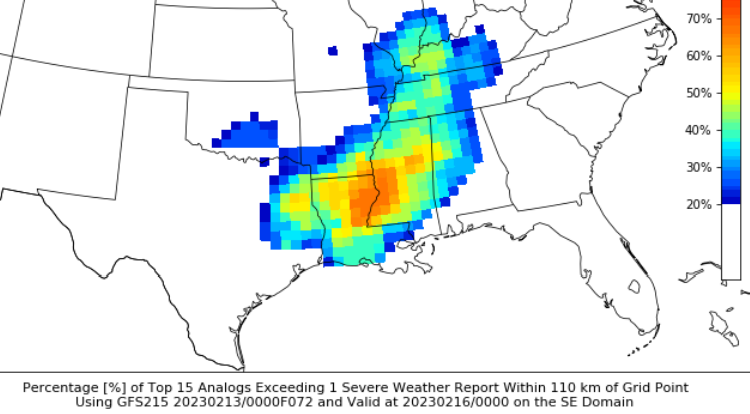
We are still looking at the potential for some severe weather on Thursday across the area. The Storm Prediction Center didn’t really make any changes to the Severe Risk area.

The only real change came from the CIPS Analogs. And it wasn’t as much of a change in the “forecast” as it is a change in the data supporting the forecast. Looking at the Analog scores, the numbers are slightly lower this mornign than the last few days. This, again, doesn’t really change the forecast, but it does change the weight that we can put on any specific outcome shown by the analogs.
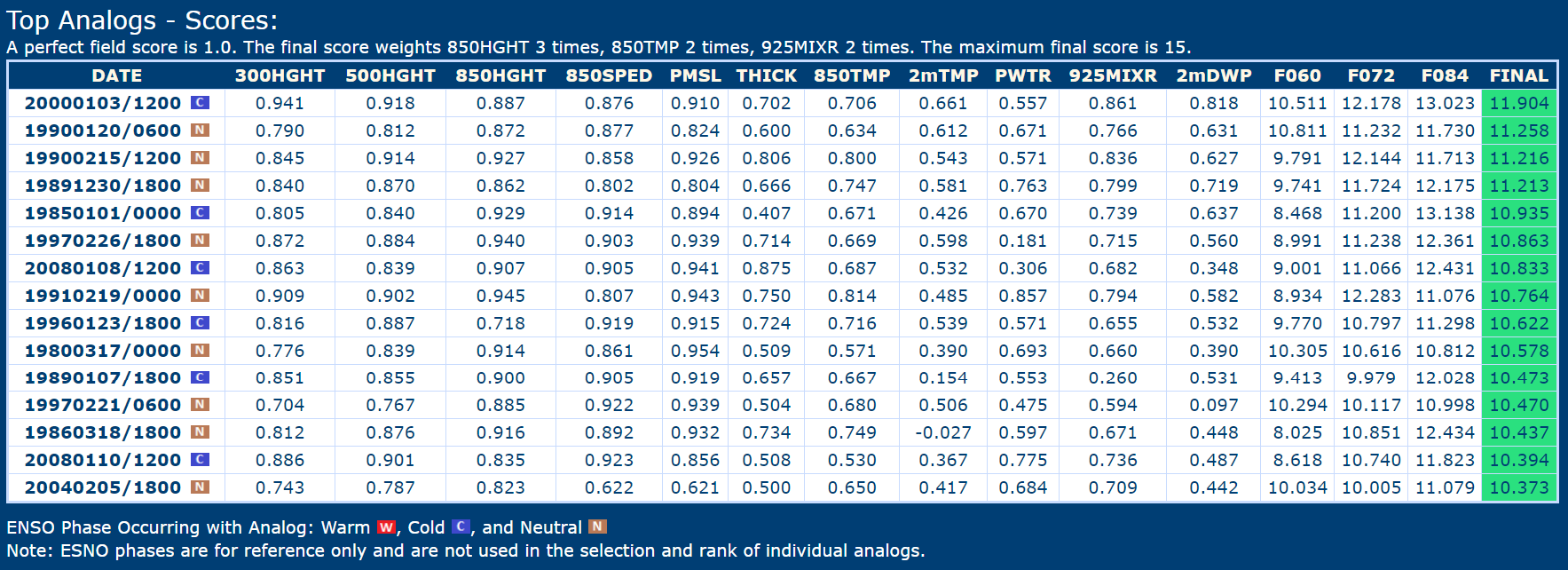
So, instead of looking at the Analog maps and going, “this is a more likely outcome than the maps shown a few days ago” we are looking at those and saying “this is a less likely outcome than the maps shown a few days ago.”
Those maps, though, continue to look pretty similar. With the bullseye for severe weather across western Mississippi and eastern Louisiana and the potential for a long track tornado across central and northern Mississippi and into Alabama.

The timeline hasn’t changed much, either.

That means that the end of all of this riff-raff is still Thursday evening, and shoudl set the stage for a nice weekend.
REGIONAL DAY TO DAY FORECAST
Today
Sunny. Not as cool with highs around 70. West winds around 5 mph.
Tonight
Mostly clear in the evening, then becoming partly cloudy. Not as cool with lows in the mid 40s. South winds around 5 mph.
Tuesday
Partly sunny. Highs in the mid 70s. South winds 10 to 15 mph with gusts up to 25 mph.
Tuesday Night
Mostly cloudy. A slight chance of showers in the evening, then a chance of showers after midnight. Not as cool. Near steady temperature in the lower 60s. South winds 10 to 15 mph with gusts up to 30 mph. Chance of rain 40 percent.
Wednesday
Cloudy with a chance of showers. A slight chance of thunderstorms in the afternoon. Highs in the mid 70s. South winds 15 to 20 mph. Chance of rain 40 percent.
Wednesday Night
Cloudy with a 40 percent chance of showers. Lows in the mid 60s.
Thursday
Showers likely with a chance of thunderstorms in the morning, then showers with thunderstorms likely in the afternoon. Some thunderstorms may be severe in the afternoon. Highs in the mid 70s. Temperature falling into the upper 60s in the afternoon. Chance of rain 90 percent.
Thursday Night
Mostly cloudy. Showers likely with a chance of thunderstorms in the evening, then a slight chance of showers after midnight. Some thunderstorms may be severe. Much cooler with lows in the upper 30s. Chance of rain 60 percent.
Friday
Mostly sunny. Much cooler with highs in the lower 50s.
Friday Night
Mostly clear. Cold with lows in the lower 30s.
Saturday
Sunny. Highs in the upper 50s.
Saturday Night
Partly cloudy. Lows in the upper 30s.
Sunday
Partly sunny. Not as cool with highs in the upper 60s.


