Another dry day today as we look toward a rainy weekend. In fact, the rain could start as early as after sundown tonight in some spots. But for most folks it’ll wait until early tomorrow morning. And then off-and-on showers and storms will last through the weekend.
The good news is that severe weather continues to look less likely.
The bad news is that all of the rain will likely put a hold on any outdoor activities.

Flash flooding in some spots may be a problem if – big if – storms train over the same areas repeatedly. Otherwise, the rainfall estimates from the model guidance don’t look particularly menacing.
HELP MAKE THE NEW NICKELBLOCK FORECASTING APP BETTER! BECOME A BETA TESTER! CHECK OUT THIS POST WITH MORE INFO ON HOW TO BETA TEST THE NEW APP ON ANDROID!
Next week, on Tuesday, things may be a bit different, though. The Storm Prediction Center has outlined parts of the area with a Slight Risk for severe weather. And the CIPS Analogs show some historical numbers that suggest part events that look like this upcoming event have produced severe weather in the past.

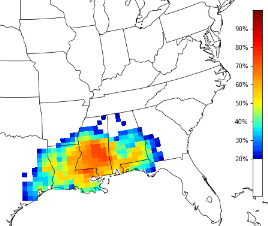
So far this looks like mainly a rain and wind event with the potential for a few brief tornadoes, but the system does warrant some extra attention as the model guidance has come back a bit more organized with this next one in successive model runs.
For the moment, not much to lose sleep over, but definitely worth checking back witht eh forecast as we move through the weekend and into next week!
REGIONAL DAY TO DAY FORECAST
Today
Partly sunny this morning, then becoming mostly cloudy. Highs in the lower 60s. North winds 5 to 10 mph.
Tonight
Cloudy. A slight chance of showers in the evening, then a chance of showers after midnight. Lows in the mid 40s. Northeast winds 5 to 10 mph. Chance of rain 50 percent.
Saturday
Cloudy with a slight chance of thunderstorms. A chance of showers in the morning, then showers likely in the afternoon. Highs in the mid 50s. Northeast winds 5 to 10 mph. Chance of rain 70 percent.
Saturday Night
Showers with a slight chance of thunderstorms. Lows in the upper 40s. East winds 10 to 15 mph. Chance of rain 90 percent.
Sunday
Cloudy in the morning, then becoming partly sunny. A 40 percent chance of showers. Highs in the lower 60s. Northwest winds 10 to 15 mph.
Sunday Night
Mostly clear. Cooler with lows in the upper 30s.MondaySunny. Highs in the upper 50s.
Monday Night
Mostly clear in the evening, then mostly cloudy with a slight chance of showers and thunderstorms after midnight. Lows in the upper 30s. Chance of rain 20 percent.
Tuesday
Cloudy. A chance of showers with a slight chance of thunderstorms in the morning, then showers with a chance of thunderstorms in the afternoon. Highs in the lower 60s. Chance of rain 80 percent.
Tuesday Night
Mostly cloudy. Showers with a chance of thunderstorms in the evening, then a chance of showers with a slight chance of thunderstorms after midnight. Breezy with lows in the mid 40s. Chance of rain 80 percent.
Wednesday
Mostly sunny. Highs in the mid 50s.
Wednesday Night
Mostly cloudy. Lows in the mid 30s.
Thursday
Sunny. Highs in the mid 50s.


