
With the upper-level high moving gradually moving out to the west, we now have the door opening for opportunities for more disturbances across the southeast US. Created by the high pressure ridge to the west and troughing to the east, the majority of the region will be under northwesterly flow aloft. This flow will help to bring new systems down off the northern Rockies and moving them towards this part of the country. Temperatures throughout much of the southeast do also look to gradually increase throughout the week, with the higher temperatures being found in the more western and northwestern parts of the region.
A departing tropical wave in the western Gulf of Mexico and dissipating stationary front across the I-20 corridor will help to maintain at least scattered thunderstorm potential from I-20 south to along the coastline over the next couple days. Locally heavy rainfall may be possible with these storms, but the overall coverage will be pretty scattered and sporadic.
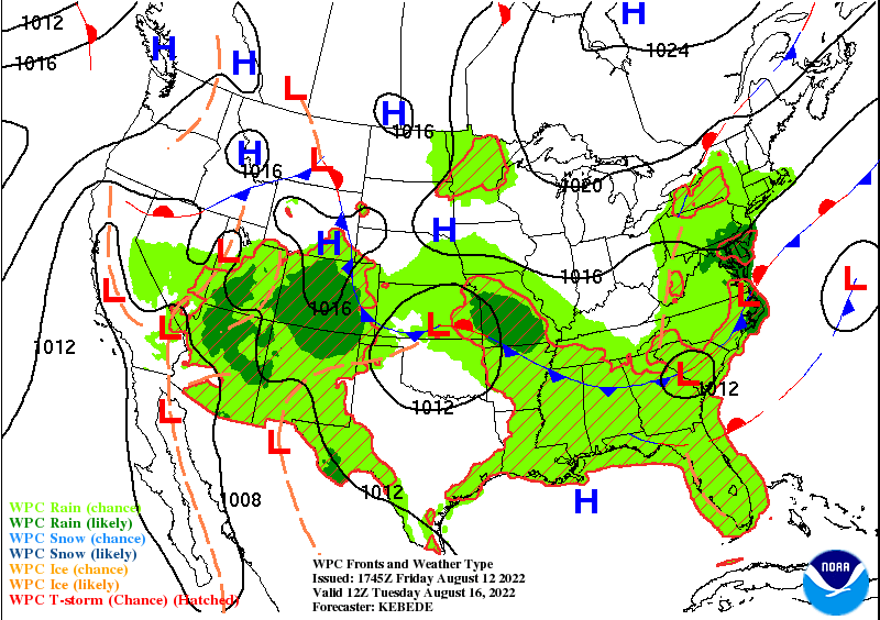
Incoming over the course of the beginning of next week, there is indications of a cold front slated to push its way southward. Timing the front’s arrival, we can anticipate it to pass through the northern southeast US (Arkansas, Tennessee, north Mississippi, north Alabama, north Geogia) by Monday-Tuesday, the central southeast US (central Georgia, Alabama, Mississippi, northern Louisiana and Texas) by Wednesday, and finally making its arrival to the coast by Thursday before stalling out close to the coast on Friday. Scattered to numerous thunderstorms will be expected in front of the front, with heavy rainfall possible, but are expected to stay below severe limits at this time.
Temperatures look to gradually increase throughout the region, with the highest temperatures being experienced for those in Texas, Arkansas, and western Louisiana. For those not in those states, temperatures are expected to rise from the upper 80s and low 90s to the low to mid 90s over the coming days. Temperatures out west look to be higher than the majority of the region, with temperatures in the upper 90s to low 100s expected. As the front approaches, temperatures may begin to increase immediately ahead of the front, due to the increased warm southerly flow and the compressing of air as the advancing front rams against the warmer air.
Local 3 Day Weather Forecast (Courtesy: NWS)
| Dallas, TX | ||
| Saturday | Sunday | Monday |
| High: 98°F | High: 100°F | High: 101°F |
| Low: 77°F | Low: 78°F | Low: 79°F |
| Precip: None | Precip: None | Precip: None |
| New Orleans, LA | ||
| Saturday | Sunday | Monday |
| High: 87°F | High: 89°F | High: 89°F |
| Low: 75°F | Low: 76°F | Low: 76°F |
| Precip: 60% | Precip: 50% | Precip: 30% |
| Little Rock, AR | ||
| Saturday | Sunday | Monday |
| High: 93°F | High: 97°F | High: 99°F |
| Low: 68°F | Low: 69°F | Low: 75°F |
| Precip: None | Precip: None | Precip: 20% |
| Memphis, TN | ||
| Saturday | Sunday | Monday |
| High: 90°F | High: 94°F | High: 94°F |
| Low: 66°F | Low: 68°F | Low: 74°F |
| Precip: None | Precip: None | Precip: 20% |
| Birmingham, AL | ||
| Saturday | Sunday | Monday |
| High: 88°F | High: 93°F | High: 93°F |
| Low: 68°F | Low: 70°F | Low: 71°F |
| Precip: None | Precip: None | Precip: 30% |
| Atlanta, GA | ||
| Saturday | Sunday | Monday |
| High: 84°F | High: 88°F | High: 90°F |
| Low: 68°F | Low: 67°F | Low: 70°F |
| Precip: None | Precip: None | Precip: 30% |


