So as I referenced last week, a cold front would be coming in this weekend with a possible rain chance. Well, that front is indeed pushing through, and with it, we’ll definitely see some rain this evening.
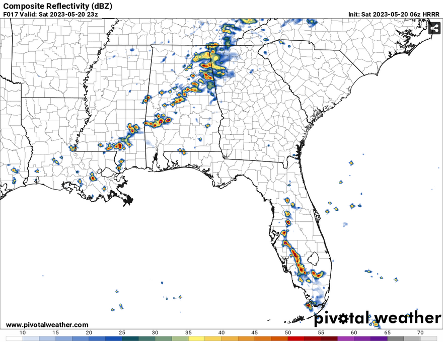
While there isn’t a lot of dynamic movement and heavy precipitable water, there will be a thin line of thunderstorms that will roll through central to south Mississippi, some strong and possibly severe. So far the timeline for these storms will be from 4-9 pm with storms sparking off south of Jackson and moving southeast across Pike county all the way east to Wayne county. Most of the Pinebelt will see some sort of thunderstorm action with storms beginning to wane in strength as they move closer to the coastline. Most of the hazards would be strong winds and possible hail.
The storms should be out for the coastline by midnight and temperatures will drop to the low 70s with some low clouds. Sunday will be mostly cloudy with a break or two, but temperatures will remain in the low to mid 80s throughout the day. Rain chances will be very low with the cold front having just moved past. Sunday night will begin to clear out the clouds overnight to bring in slightly cooler temperatures on Monday.
EXTRA WEATHER MAPS
Here is a look at some extra weather data!
Select Data Set:

If you’d like to see any weather data in particular here, make a request! We’ll do our best to see what we can find.
[wpcode id=”41149″]
Regional Day-to-Day Forecast
Today – Showers and thunderstorms likely in the afternoon. Mostly sunny, with a high near 91. West northwest wind around 5 mph. Chance of precipitation is 60%. New rainfall amounts between a tenth and quarter of an inch, except higher amounts possible in thunderstorms.
Tonight – A 30 percent chance of showers and thunderstorms until midnight. Mostly cloudy, with a low around 65. North wind around 5 mph.
Sunday – Mostly cloudy, with a high near 84. North wind 5 to 10 mph.
Sunday Night – Cloudy, then gradually becoming partly cloudy, with a low around 65. North wind around 5 mph becoming calm in the evening.
Monday – A 20 percent chance of showers and thunderstorms in the afternoon. Mostly sunny, with a high near 85. Calm wind becoming north around 5 mph in the morning.
Monday Night – Partly cloudy, with a low around 65. North wind around 5 mph becoming calm in the evening.
Tuesday – A slight chance of showers, then a chance of showers and thunderstorms in the afternoon. Mostly sunny, with highs in the mid 80s. Calm wind becoming northeast around 5 mph in the morning. Chance of precipitation is 40%.
Tuesday Night – Partly cloudy, with lows in the mid 60s. East northeast wind around 5 mph becoming calm in the evening.
Wednesday – A 30 percent chance of showers in the afternoon. Mostly sunny, with highs in the low to mid 80s. Light east northeast wind increasing to 5 to 10 mph in the morning.
Wednesday Night – Partly cloudy, with lows in the low 60s.
Thursday – A 20 percent chance of showers and thunderstorms. Mostly sunny, with highs in the mid 80s.
Thursday Night – Mostly clear, with lows in the mid 60s.
Friday – Sunny, with highs in the upper 80s.
[wpcode id=”41149″]


