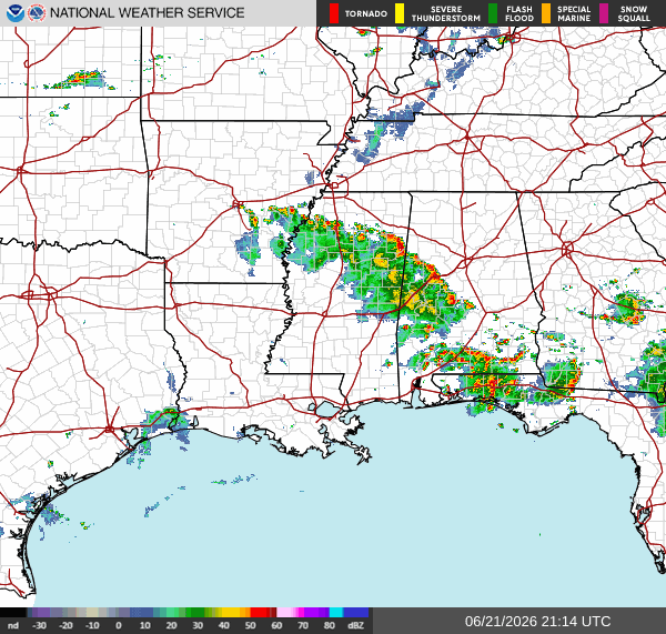
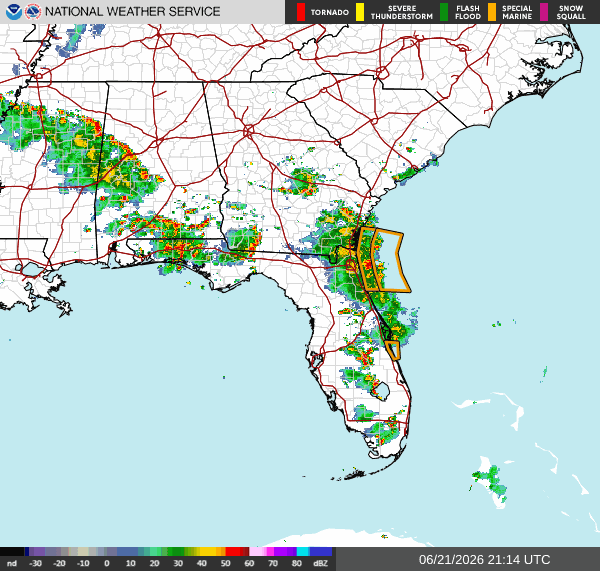
Current Conditions
Scattered showers and thunderstorms stretching from MS to FL, moving east-northeast. Some areas could see excessive rainfall. Special Marine Warnings issued on the GA and Northern FL coast.
Tonight
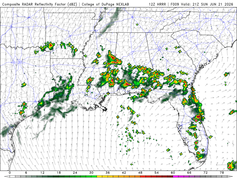
Scattered showers and thunderstorms in the deep south are moving east this evening. LA and MS will clear up around 9 pm, followed by AL, GA, and FL around 11 pm. TN will have isolated showers and possible thunderstorms moving into the West around 11 pm.
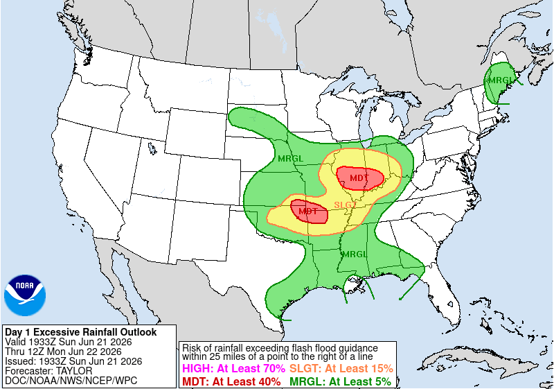
Parts of LA, TN, AL, and GA, as well as MS and the FL Panhandle, are under a marginal risk for excessive rainfall, which means a small chance for flashing flood. West of TN is under a slight risk for excessive rainfall. This means scattered flash flooding is possible.
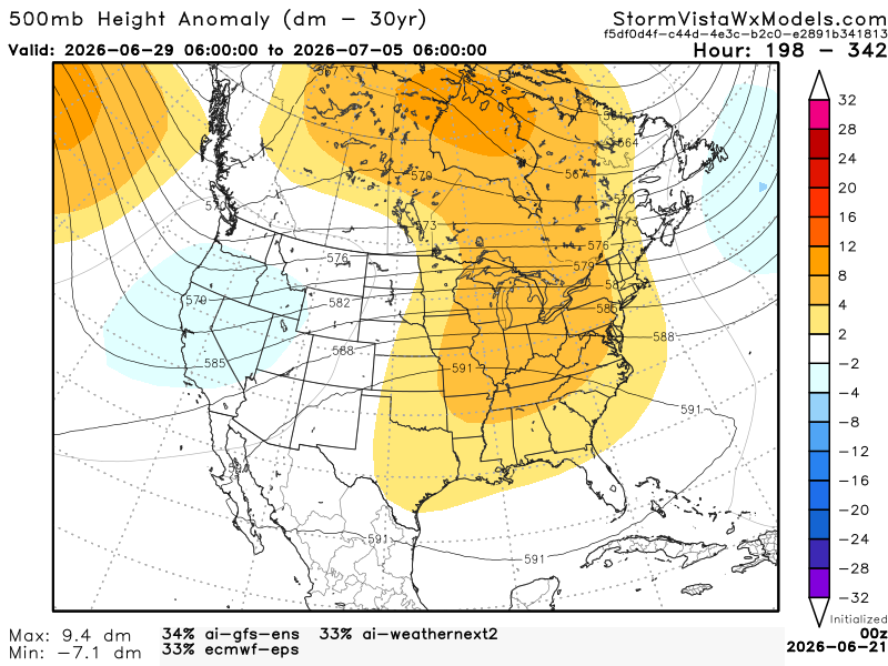
Extended Regional Outlook
The CPC outlook has our region above normal for temperatures and normal for precipitation from June 29th to July 5th.


Below, we have 3 of the most accurate models blended into one model. This model gives us an idea of the possible outcome from June 29th to July 5th. Based on this blend of models, the Southern region will be warmer under the ridging. The Gulf will bring in moisture, so the heat index will be high. As for the precipitation, we will experience more isolated showers and storms in the afternoons due to the sea breeze bringing cool ocean air during the day. The typical summer setup here in the south for storms.
3 Day Traveling Forecast
KHOU – Houston: Temperatures in the 90s. Going to be windy, then breezy Tuesday. Slight chance for thunderstorms this afternoon. Possible delays at the airport due to lightning. No weather is anticipated for the next 2 days!
KSHV – Shreveport: Temperatures around the 90s. Going to be breezy. Chances for thunderstorms this afternoon, then expecting showers Monday night into Tuesday morning. Possible delays at the airport this afternoon due to lightning.
KBTR – Baton Rouge: Temperatures in the 90s. Going to be breezy. No weather is anticipated for the next 3 days!
KMSY – New Orleans: Temperatures in the 90s. Going to be breezy. No weather is anticipated until Tuesday with a slight chance for thunderstorms. Possible delays at the airport on Tuesday due to lightning.
KJAN – Jackson: Temperatures in the 90s. Going to be windy. Thunderstorms and showers are anticipated for the next 3 days. Possible delays at the airport due to lightning.
KBHM – Birmingham: Temperatures in the 80s. Going to be breezy. Thunderstorms and showers are anticipated for the next 3 days. Possible delays at the airport due to lightning.
KMOB – Mobile: Temperatures in the 90s. Going to be breezy. Thunderstorms and showers are anticipated for the next 3 days. Possible delays at the airport due to lightning.
KATL – Atlanta: Temperatures in the 80s. Going to be windy. Thunderstorms and showers are anticipated for the next 3 days. Possible delays at the airport due to lightning.
KTLH – Tallahassee: Temperatures in the 90s. Going to be breezy. Thunderstorms and showers are anticipated for the next 3 days. Possible delays at the airport due to lightning.
Today’s Interstate Forecast
I-10: Scattered showers and thunderstorms toward the East in FL and AL. Showers toward the West near the TX/LA border. Will be mostly clear around the evening or early nighttime hours.
I-20: Showers and thunderstorms moving east near the Central MS/AL border. Will start to clear up around the late evening.
I-49: Showers in Central LA. Will be clear around the late evening.
I-55: Isolated showers and thunderstorms in MS. Will clear up around the evening. Light showers near Northern MS during the late nighttime hours.
I-59: Showers and thunderstorms moving east near the Central MS/AL border. Will start to clear up around the late evening.
I-65: Scattered showers and thunderstorms up to Montgomery, AL. Will be mostly clear around the early evening. Isolated thunderstorm near Southern AL around the late evening. Will clear up around the early nighttime hours.
I-75: Scattered showers and thunderstorms stretching from FL to Central GA, moving East. Will be mostly clear around the nighttime hours.
3 Day City Forecast
Houston, TX: Today, highs in the lower 90s with a slight chance for thunderstorms. Tonight, partly cloudy with lows in the lower 80s. Monday, mostly sunny with highs in the lower 90s. Monday night, cloud cover will increase overnight with lows in the lower 80s. Tuesday, mostly sunny with highs in the mid-90s. Tuesday night, mostly clear with lows in the upper 70s. Windy today and Monday. Breezy Tuesday.
Shreveport, LA: Today, highs in the upper 80s with a chance for thunderstorms. Tonight, mostly clear with lows in the upper 70s. Monday, mostly sunny with highs in the mid-90s. Monday night, partly cloudy with lows in the lower 80s, and slight chance for showers. Tuesday, partly sunny with highs in the mid-90s. Tuesday night, partly cloudy with lows in the upper 70s. Windy today. Breezy Monday and Tuesday.
Baton Rouge, LA: Today, partly cloudy with highs in the mid-90s. Tonight, partly cloudy with lows in the upper 70s. Monday, sunny with highs in the mid-90s. Monday night, cloud cover will increase overnight with lows in the upper 70s. Tuesday, mostly sunny with highs in the mid-90s. Tuesday night, partly cloudy with lows in the mid-70s. Breezy all 3 days.
New Orleans, LA: Today, partly cloudy with highs in the lower 90s. Tonight, partly cloudy with lows in the lower 80s. Monday, sunny with highs in the lower 90s. Monday night, mostly clear with lows in the lower 80s. Tuesday, mostly sunny with highs in the mid-90s, and a slight chance for thunderstorms. Tuesday night, partly cloudy with lows in the upper 70s. Breezy all 3 days.
Jackson, MS: Today, highs in the upper 80s, and a slight chance for thunderstorms. Tonight, partly cloudy with lows in the mid-70s, and a chance for thunderstorms. Monday, highs in the mid-80s, and showers and thunderstorms are likely. Monday night, lows in the lower 70s, and showers and thunderstorms are likely. Tuesday, highs in the mid-80s, and chances for showers. Tuesday night, lows in the upper 60s, and showers and thunderstorms are likely. Windy today and Monday. Breezy on Tuesday.
Birmingham, AL: Today, highs in the upper 80s, and a chance for thunderstorms. Tonight, lows in the mid-70s, and a chance for thunderstorms. Monday, highs in the upper 80s, and showers and thunderstorms are likely. Monday night, lows in the lower 70s, and showers are likely. Tuesday, highs in the mid-80s, and chances for showers and thunderstorms. Tuesday night, lows in the lower 70s, and a slight chance for thunderstorms. Breezy all 3 days.
Mobile, AL: Today, highs in the upper 80s, and a chance for thunderstorms. Tonight, lows in the lower 80s, and a slight chance for thunderstorms. Monday, highs in the lower 90s, and a slight chance for thunderstorms. Monday night, partly cloudy with lows in the lower 70s. Tuesday, highs in the mid-90s, and a chance for thunderstorms. Tuesday night, lows in the upper 70s, and chances for showers and thunderstorms. Breezy all 3 days.
Atlanta, GA: Today, highs in the upper 80s, and a slight chance for thunderstorms. Tonight, lows in the lower 70s, and a slight chance for thunderstorms. Monday, highs in the upper 80s, and a slight chance for showers and thunderstorms. Monday night, lows in the lower 70s, and a chance for showers. Tuesday, highs in the mid-80s, and chances for showers and thunderstorms. Tuesday night, lows in the upper 60s, and a chance for thunderstorms. Windy all 3 days.
Tallahassee, FL: Today, highs in the mid-80s, and chances for thunderstorms are likely. Tonight, lows in the mid-70s, and a chance for thunderstorms. Monday, highs in the lower 90s, and a slight chance for showers and thunderstorms. Monday night, partly cloudy with lows in the mid-70s. Tuesday, highs in the mid-90s, and a chance for thunderstorms is likely. Tuesday night, lows in the mid-70s, and a chance for showers and thunderstorms is likely. Breezy all 3 days.


