We have found some relief from the high temperatures! As a cold front passed through our region, moving southeast, the temperatures dropped a decent amount. Now, we are seeing temperatures in the 80s. Also, the temperatures don’t feel like we’re in the triple digits today.
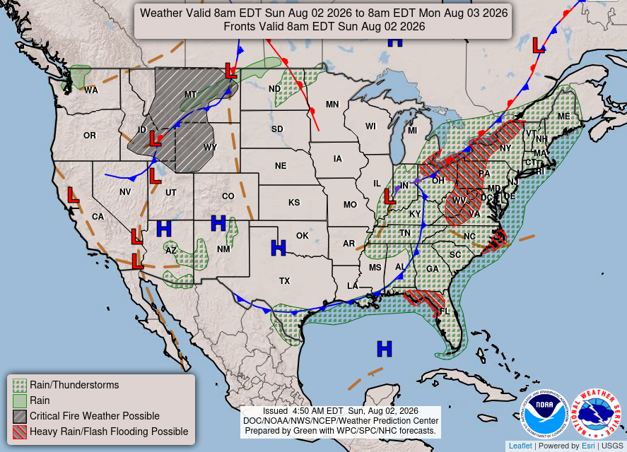
Tonight
With a low-pressure area near Illinois, a trough pattern extends into the Deep South. Because of these factors, we are seeing scattered showers and thunderstorms along the boundary. According to NWS, heavy rain and flash flooding will be mostly in the FL Panhandle.
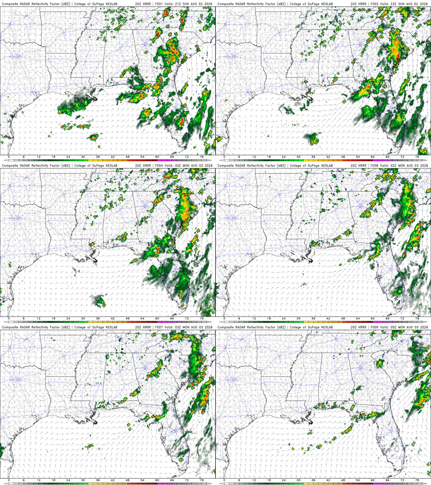
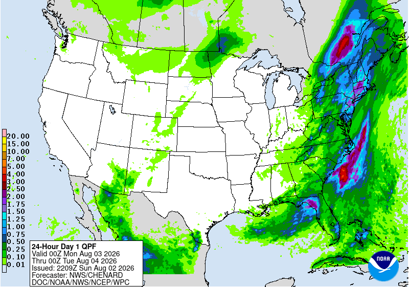
Near the west end of the FL Panhandle, total rainfall could be around 2 inches, possibly more in localized areas.
Today’s Interstate Forecast
I-10: Scattered showers and thunderstorms throughout FL. Possible isolated showers and thunderstorms in southern MS and AL during the nighttime hours.
I-20: Showers and thunderstorms in central GA. Possible isolated showers near central AL.
I-49: No weather anticipated.
I-55: Possible isolated showers near central MS during the evening.
I-59: Possible isolated showers throughout MS and AL.
I-65: Isolated to scattered showers and thunderstorms near central to northern AL and southern AL.
I-75: Scattered showers and thunderstorms throughout FL.
3 Day Traveling Forecast
KHOU – Houston: Chance of thunderstorms Monday. Possible delays at the airport due to lightning.
KSHV – Shreveport: No weather is anticipated for the next 3 days!
KBTR – Baton Rouge: No weather is anticipated for the next 3 days!
KMSY – New Orleans: No weather is anticipated for the next 3 days!
KJAN – Jackson: No weather is anticipated for the next 3 days!
KBHM – Birmingham: Chance of thunderstorms Monday and Tuesday. Possible delays at the airport due to lightning.
KMOB – Mobile: Chance of thunderstorms tonight and Tuesday. Possible delays at the airport due to lightning.
KATL – Atlanta: Chance of thunderstorms Monday and Tuesday. Possible delays at the airport due to lightning.
KTLH – Tallahassee: Chance of thunderstorms all 3 days. Possible delays at the airport due to lightning.
3 Day City Forecast
Houston, TX:
Tonight – Clear with patchy fog. Low of 78 F.
Monday – Patchy fog during the day. Possible isolated thunderstorms. High of 99 F. Mostly clear overnight. Possible isolated thunderstorms. Low of 78 F.
Tuesday – Sunny during the day. High of 97 F. Mostly clear overnight. Low of 79 F.
Shreveport, LA:
Tonight – Mostly clear. Low of 71 F.
Monday – Hot during the day. High of 97 F. Mostly clear overnight. Low of 74 F.
Tuesday – Hot during the day. High of 98 F. Mostly clear overnight. Low of 77 F.
Baton Rouge, LA:
Tonight – Mostly clear. Low of 74 F.
Monday – Hot during the day. High of 95 F. Mostly clear overnight. Low of 75 F.
Tuesday – Hot during the day. High of 97 F. Mostly clear overnight. Low of 76 F.
New Orleans, LA:
Tonight – Partly cloudy. Low of 77 F.
Monday – Sunny during the day. High of 91 F. Partly cloudy overnight. Low of 78 F.
Tuesday – Sunny during the day. High of 93 F. Mostly clear overnight. Low of 79 F.
Jackson, MS:
Tonight – Mostly clear. Low of 69 F.
Monday – Sunny during the day. High of 92 F. Mostly clear overnight. Low of 70 F.
Tuesday – Sunny during the day. High of 95 F. Mostly clear overnight. Low of 72 F.
Birmingham, AL:
Tonight – Partly cloudy. Low 69 F.
Monday – Mostly sunny during the day. Slight chance of thunderstorms. High of 86 F. Partly cloudy overnight. Low of 70 F.
Tuesday – Mostly sunny during the day. Slight chance of thunderstorms. High of 89 F. Partly cloudy overnight. Low of 72 F.
Mobile, AL:
Tonight – Mostly clear. Slight chance for thunderstorms. Low of 73 F.
Monday – Partly cloudy during the day. High of 92 F. Partly cloudy overnight. Low of 75 F.
Tuesday – Sunny during the day. Slight chance of thunderstorms. High of 94 F. Mostly clear overnight. Low of 76 F.
Atlanta, GA:
Tonight – Partly cloudy. Low 69 F.
Monday – Mostly sunny during the day. Chance of thunderstorms. High of 87 F. Partly cloudy overnight. Chance of thunderstorms. Low of 71 F.
Tuesday – Mostly sunny during the day. Chance of thunderstorms. High of 87 F. Chance of showers overnight. Low of 71 F.
Tallahassee, FL:
Tonight – Chance for showers and thunderstorms. Flood watch. Low of 73 F.
Monday – Showers and thunderstorms likely during the day. Flood watch until 8 pm. High of 88 F. Partly cloudy overnight. Thunderstorms likely. Low of 72 F.
Tuesday – Sunny during the day. Thunderstorms likely. High of 90 F. Mostly clear overnight. Thunderstorms likely. Low of 73 F.
Extended Regional Outlook
The CPC outlooks have our region feeling warmer than average, along with normal precipitation amounts.


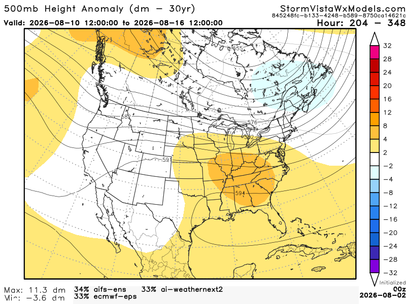
Below, we have 3 of the most accurate models blended into one model. This gives us an idea of the possible outcomes from August 10th (7 am) to August 16th (7 am). Based on this blend of models, the Southern region will most likely see those warm temperatures and normal precipitation amounts. We have a strong positive anomaly over the south, meaning we could feel heat dome-like conditions. With this kind of setup, we won’t have long-lived storms. We will experience our normal sea breeze thunderstorms during the afternoon and evening.