But first we got to get through the heat.
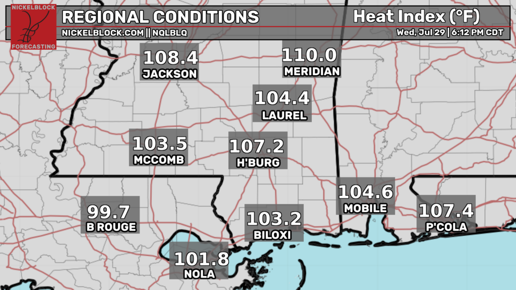
That’s easier said than done.
Tomorrow will still be very hot but temperatures will begin to moderate after that as rain chances increase. It doesn’t look like every day will be a washout for everyone but most locations will likely see some decent rain by early next week.
Severe weather chances look to be low but not zero. The main threat would be damaging winds if storms are able to congeal into an organized cluster.
Highs will be lower than they have been allowing for some relief from the heat but not cool. Thinking maybe upper 80s for the weekend.

Tonight
It’ll be very humid. That’d for sure.
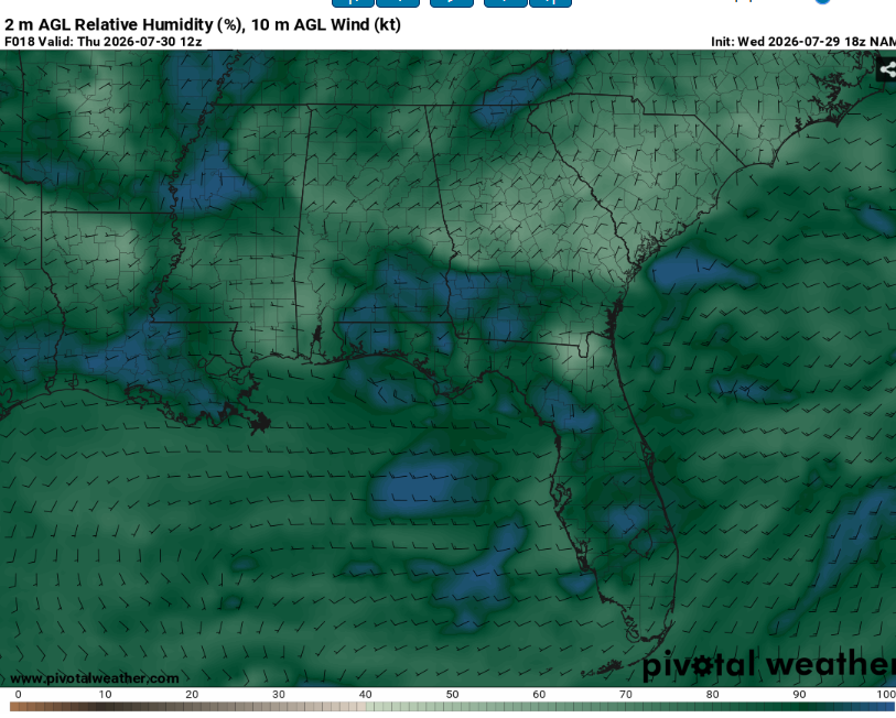
Given the high dew points, position of the high, and light winds, some patchy fog may be possible. This will be most likely in low lying areas such as river valleys and locations that have recently received rainfall. Use caution and slow down when encountering low visibility.
There may also be a chance for some storms. This would be most likely over southern Mississippi before midnight. It won’t be anything crazy but they might produce some heavy rain and lightning (great sleeping weather).
Lows will be in the mid to upper 70s.
Tomorrow
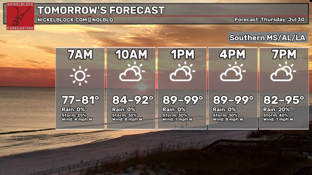
One more day of very hot temperatures.
Some people may even get lucky enough that the storms will cool them off beforehand. Highs will be in the mid 90s for places that aren’t impacted by convection. Heat indexes may exceed 105. Drink plenty of water and take frequent breaks in the AC if you must be outside.
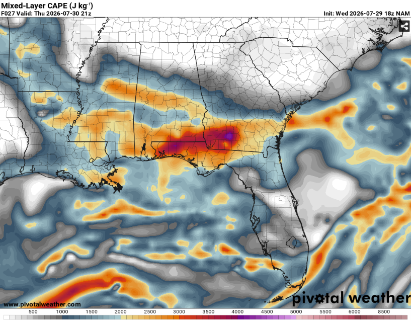
Given all the heat and moisture, instability (storm fuel) will be seasonably strong. This will allow for robust updrafts capable of very heavy rain and frequent cloud to ground lightning. A few storms may be strong enough to produce wind gusts up to 60 mph, especially in areas to our west where the Storm Prediction Center has outlined a marginal risk.
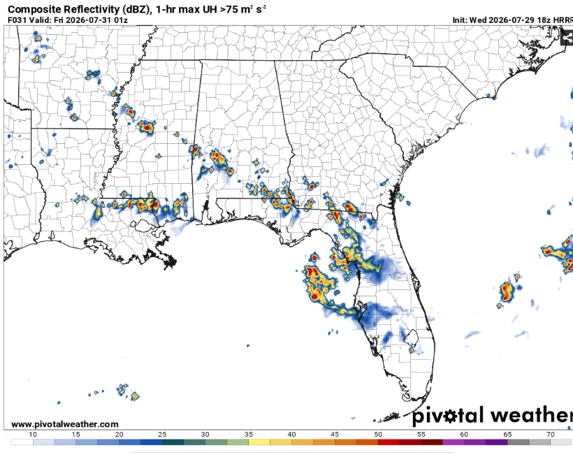
Storm coverage should only remain scattered at best though, due to the weak synoptic scale forcing and marginal vertical wind shear. Convection will likely form by mid to late afternoon and last until the mid evening.
Clouds will build throughout the day as daytime heating intensifies. Some fog may possible towards sunrise on Friday if mid and upper level clouds clear out sufficiently.

The Day After Tomorrow
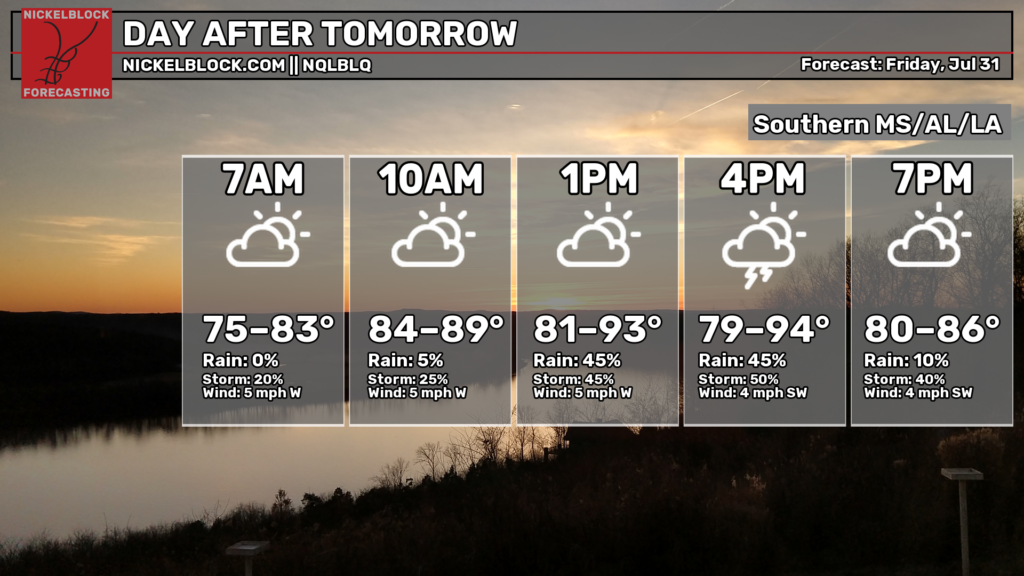
Similar to Thursday but a little less heat and a little more storm coverage. Highs will likely peak in the lower 90s before cumulus clouds explode into thunderstorms.
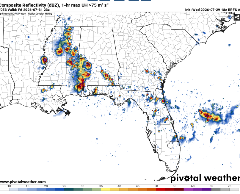
Storms will be more widespread across the region, likely peaking during the dinner time hour. Severe weather chances will again be low due to the lack of upper level support.
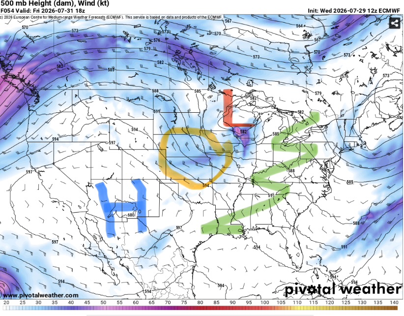
Our region will be stuck under the secondary ridge axis while the main ridge retrogrades to the west with a shortwave trough in between. This weakness in wind shear will mean that storms will struggle to organize and therefore move more based on propagation than actual translation.
Heavy rain will still be common along with lots of lightning. Storms may last into the late evening hours before fizzling out with the loss of daytime heating.

The Extended Outlook
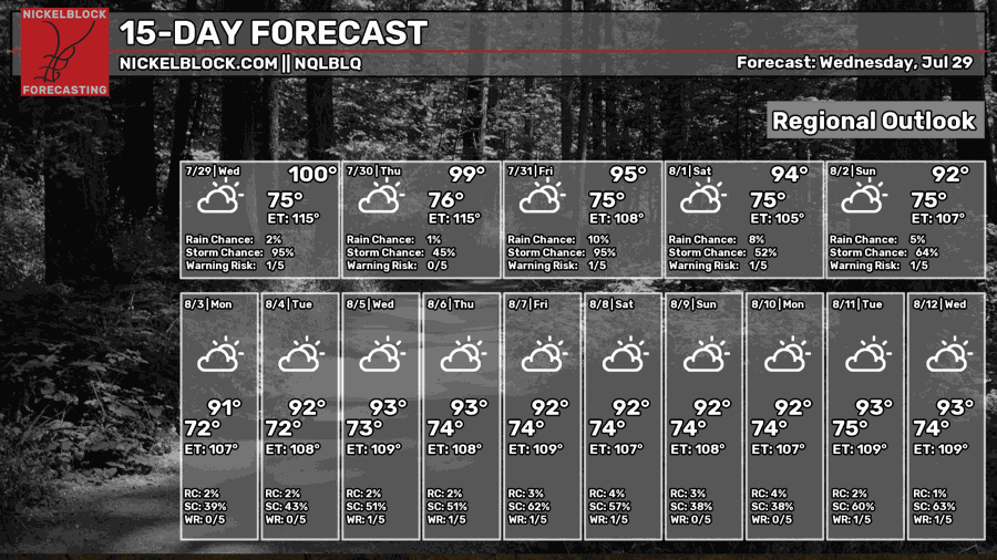
The ridge looks to settle over the Southwest for the foreseeable future. This may open us up to ridge rider thunderstorm complexes. These are notoriously hard to predict but can be very impactful with heavy rain and damaging winds.
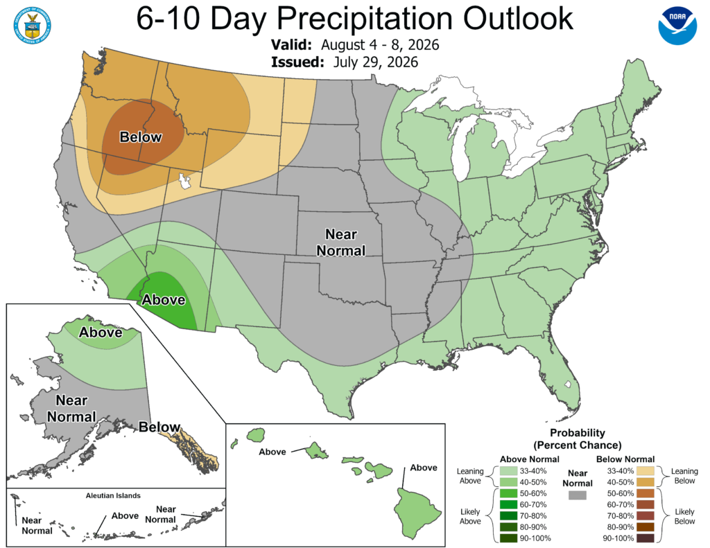
The Climate Prediction Center forecast favors a slightly wetter than average forecast. They also highlighted the entire Gulf coast region at a slight risk for excessive heat from August 6-12. Even if that doesn’t materialize, it doesn’t look like it will cool (especially with the overnight lows).
Day-By-Day Forecast
Tonight- Isolated thunderstorms possible before midnight. Partly cloudy with a low in the upper 70s. Some fog is possible.
Tomorrow- Scattered afternoon thunderstorms likely. Increasing clouds with a high in the mid 90s.
Tomorrow Night- Scattered thunderstorms possible early. Partly cloudy with a low in the upper 70s.
Friday- Increasing clouds with a high in the mid 90s. Scattered afternoon thunderstorms likely.
Friday Night- Scattered thunderstorms possible. Mostly cloudy with a low in the mid 70s.
Saturday- Partly sunny with a high in the low 90s. Scattered afternoon thunderstorms likely.
Saturday Night- Scattered thunderstorms possible. Mostly cloudy with a low in the mid 70s.
Sunday- Partly sunny with a high in the upper 80s. Scattered thunderstorms possible.
Sunday Night- Isolated thunderstorms possible early. Partly cloudy with a low in the mid 70s.
Monday- Increasing clouds with a high in the low 90s. Scattered afternoon thunderstorms possible.
Monday Night- Partly cloudy with a low in the mid 70s. No rain.
Tuesday- Scattered afternoon thunderstorms possible. Increasing clouds with a high in the mid 90s.
Tuesday Night- Partly cloudy with a low in the mid 70s. No precip expected.


