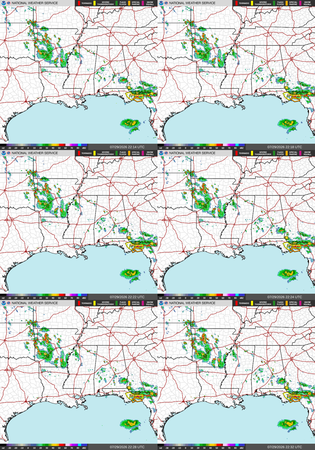
Good evening! As I’m writing this at 5:40p CDT, we have a bit of action on our radar. The main area of storms is over the Florida panhandle in the Tallahassee area. These storms are moving south, and should move over the water by 8 tonight, when they should fizzle out. A second round of storms is possible a bit further west, but they too will fizzle out when they move over the ocean by midnight.
These storms are quite strong, many areas to the south of Tallahassee are under a severe thunderstorm warning. Watch out for water on the roads, gusty winds, periods of heavy rain, and lightning. There are also a few storms in western and southwestern Arkansas which may move further south into the Shreveport area.
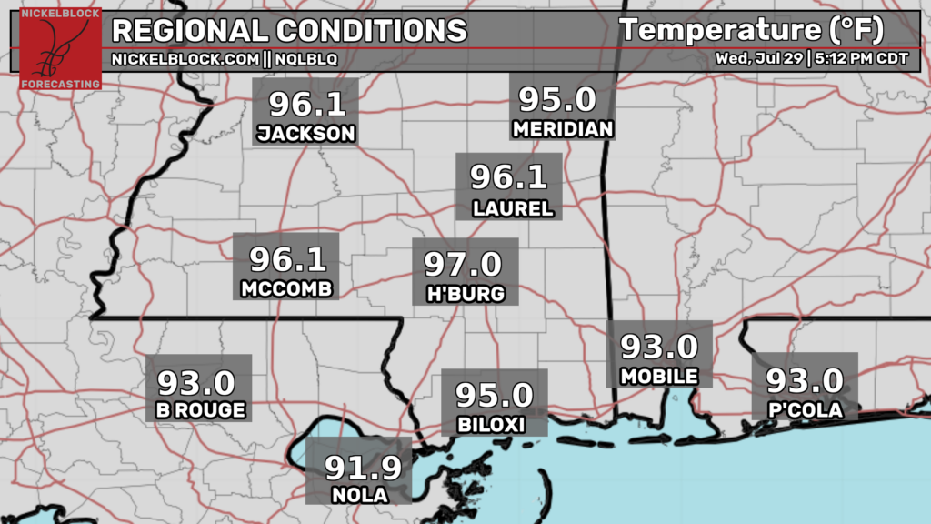
Currently, temperatures are quite hot in the mid-upper 90s for most places. While storms to break the heat aren’t likely in areas west of Mobile, the temperatures will still drop into the 70s and 80s tonight providing some relief.
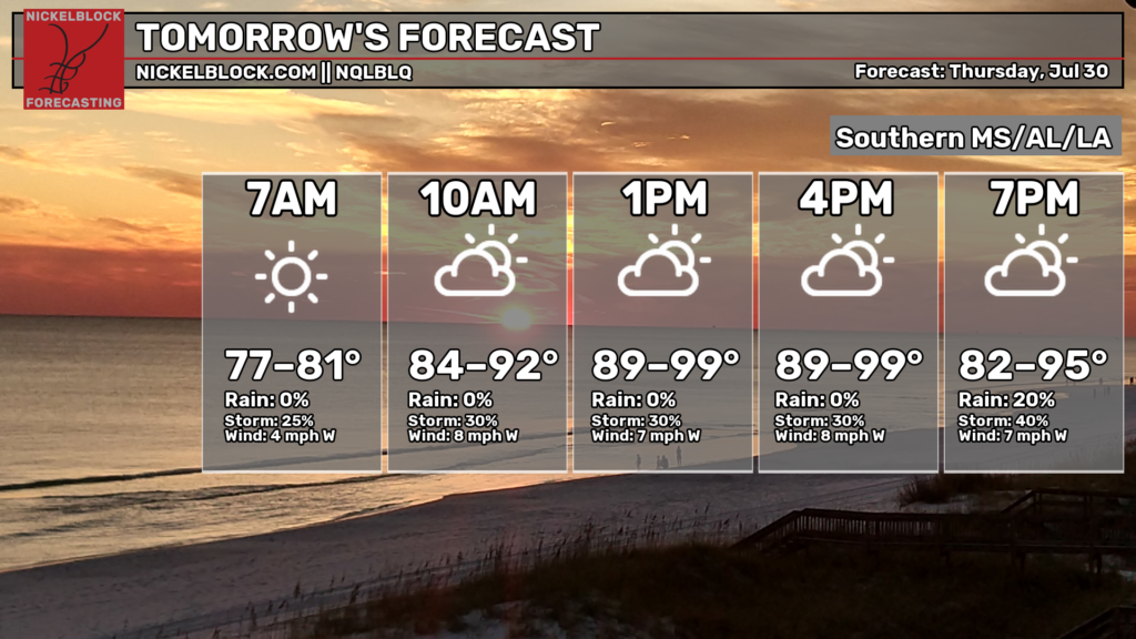
Moving into tomorrow, we’re expecting yet another hot day along the gulf coast. What’s new?
Temperatures will rise throughout the day tomorrow reaching their peak in the late afternoon and early evening. During those hours tomorrow, you can expect temperatures in the upper 90s, and possibly the low 100s in a few spots. As usual, make sure you are taking the proper precautions to protect yourself from the heat.
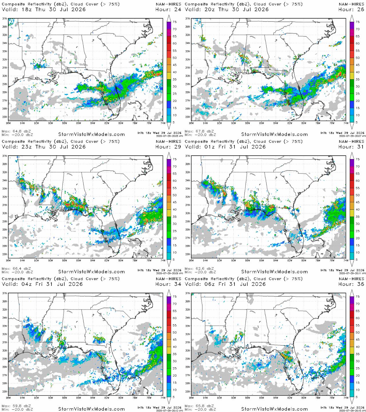
Some potentially strong storms may develop tomorrow throughout our region, particularly in southern Alabama and the Florida panhandle. Some storms may also develop in the Starkville area and make their way south. Storms will start around 2 pm and should be mostly gone by midnight.
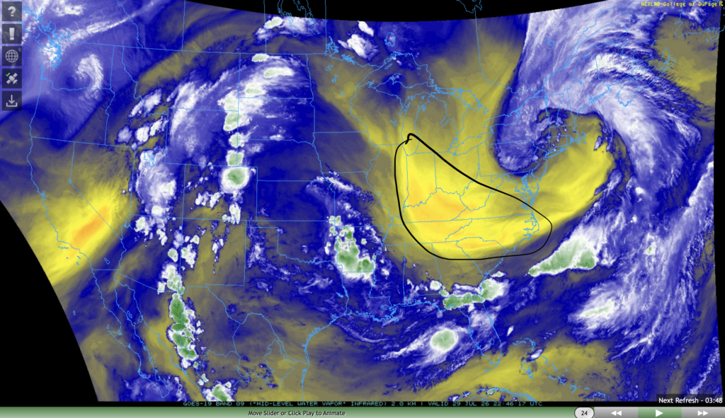
Storms will be largely absent in the Birmingham area and Georgia due to an intrusion of dry air that will make its way into that area by tomorrow.
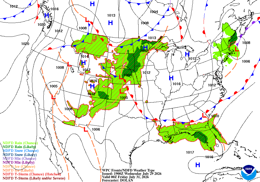
Airport Forecast
KHOU/KIAH (Houston) – Current: temperature is 95ºF, dew point is 74ºF, sky conditions are partly cloudy, winds are coming out of the southwest at 10 mph with gusts up to 17 mph, and visibility is 10 miles. Tonight: skies will remain partly cloudy and no storms are likely. No delays are expected.
KATL (Atlanta) – Current: temperature is 87ºF, dew point is 73ºF, sky conditions are mostly cloudy, winds are coming out of the northwest at 10 mph, and visibility is 9 miles. Tonight: skies will clear up, no storms are expected, however winds will get gusty. Minor delays are possible due to wind.
KMSY (New Orleans) – Current: temperature is 93ºF, dew point is 75ºF, sky conditions are mostly cloudy, winds are coming out of the southwest at 8 mph, and visibility is 10 miles. Tonight: skies will be partly cloudy and no storms are expected. No delays are expected.
KBTR (Baton Rouge) Current: temperature is 93ºF, dew point is 75ºF, sky conditions are partly cloudy, winds are coming out of the west at 10 mph with gusts up to 16 mph, and visibility is 10 miles. Tonight: skies will remain partly cloudy and no storms are expected. No delays are expected.
KSHV (Shreveport) – Current: temperature is 93ºF, dew point is 73ºF, sky conditions are mostly cloudy, winds are coming out of the southwest at 3 mph, and visibility is 10 miles. Tonight: Skies will be partly cloudy and storms are not likely. No delays are expected.
KJAN (Jackson) – Current: temperature is 97ºF, dew point is 76ºF, sky conditions are mostly cloudy, winds are coming out of the west at 8 mph, and visibility is 10 miles. Tonight: a few storms are possible between 8 pm and midnight tonight. Minor delays are possible.
KBHM (Birmingham) – Current: temperature is 93ºF, dew point is 75ºF, sky conditions are overcast, winds are coming out of the north at 8 mph, and visibility is 10 miles. Tonight: there is a very slight chance of storms before 7 pm tonight. No delays are expected.
KMOB (Mobile) – Current: temperature is 95ºF, dew point is 75ºF, sky conditions are mostly cloudy, winds are coming out of every which direction at 5 mph, and visibility is 10 miles. Tonight: there is a slight chance of storms until 10 pm tonight. Very minor delays are possible.
KTLH (Tallahassee) – Current: temperature is 101ºF, dew point is 70ºF, sky conditions are mostly cloudy, winds are coming out of the northwest at 10 mph with gusts up to 20 mph. Tonight: potentially strong storms are possible between 6pm and midnight tonight. Expect some delays.
Highway Forecast
I-10: Driving conditions will be very good tonight between Houston and Mobile. Between Mobile and the Atlantic coast, a strong line of storms is likely to pass through the area between 6 pm and after midnight tonight. Watch out for water on the roads, gusty winds, and periods of heavy rain.
I-20: A few storms are possible between Shreveport and Starkville between 5 pm and midnight tonight, but storms won’t be too widespread. Everywhere else driving conditions look good.
I-49: No storms are likely anywhere in the Louisiana portion of this highway, but some storms are possible tonight in the southwestern Arkansas portion. Overall, driving conditions will be excellent today.
I-55: A few storms are possible near the AR/LA/MS border tonight between 5 and 10 pm, but other than that, no storms are expected anywhere else. Overall, driving conditions will be good.
I-59: Little to no storms are expected along the entire portion of this highway tonight. Overall, driving conditions will be excellent tonight.
I-65: A line of storms will likely pass through the area south of Montgomery near the Andalusia/Enterprise area between 5 pm and midnight tonight. A few storms are also possible in the Mobile area. Watch out for water on the roads, gusty winds, and periods of heavy rain.
I-75: A line of potentially strong storms will likely form south of Albany, GA and Macon at around 5 tonight. This line of storms will move south into northern Florida by 8 tonight, and will reach the coastline by midnight. Areas in central Florida may see storms until past midnight. Driving conditions will be excellent north of Macon, but poor south of Macon into Florida.
3 Day City Forecast
Tallahassee, FL
Tomorrow: Skies will be sunny in the morning with cloud cover increasing as the day goes on with a high of 94ºF. Potentially strong storms are possible between 3 and 9 pm tomorrow. Rainfall totals could be between a quarter and a half inch of rain, with more for areas hit by a thunderstorm. By night, skies will be mostly cloudy and the temperature should drop into the mid 70s.
Friday: Skies will be mostly cloudy in the morning, with sunny skies emerging by afternoon with a high of 92ºF. Storms are possible in the late night hours lasting until past midnight. By night, skies will be partly cloudy and temperatures should fall into the mid 70s.
Saturday: Skies will be partly cloudy throughout the day on Saturday with a high of 90ºF. There is a chance of showers and storms between 2 and 8 pm. By night, the temperatures should drop into the low-mid 70s.
Birmingham, AL
Tomorrow: Skies will be sunny throughout the day tomorrow with a high of 92ºF. Humidity will be noticeably lower, and no storms are expected. By night, skies will be partly cloudy and temperatures should drop into the low 70s.
Friday: Skies will be mostly sunny throughout the day on Friday with a high of 93ºF. Some storms are possible in the late night hours past midnight. By night, skies will be mostly cloudy and temperatures should drop into the low-mid 70s.
Saturday: Skies will be mostly stormy throughout the day on Saturday with a high of 86ºF. Storms are possible all throughout the day on Saturday. By night, skies will be mostly cloudy and temperatures should drop into the low 70s.
Mobile, AL
Tomorrow: Skies will be mostly sunny throughout the day tomorrow with a high of 94ºF. Some potentially strong storms are possible between 3 and midnight tomorrow night. By night, skies will be partly cloudy and temperatures should drop into the mid 70s.
Friday: Skies will be partly cloudy throughout the day on Friday with a high of 92ºF. Storms and showers are possible between lunchtime and 10-11 pm. By night, skies will be mostly cloudy and temperatures should drop into the mid 70s.
Saturday: Skies will be partly sunny throughout the day on Saturday with a high of 90ºF. Storms and showers are possible in the afternoon and evening lasting into the night. By night, skies will be mostly cloudy and the temperature should drop into the mid 70s.
Atlanta, GA
Tomorrow: Skies will be sunny throughout the day with a high of 91ºF. No storms are expected tomorrow. By night, skies will be mostly clear and temperatures should drop into the refreshing upper 60s.
Friday: Skies will be sunny throughout the day on Friday with a high of 92ºF. No storms are expected on Friday. By night, skies will be partly cloudy and temperatures should drop into the low-mid 70s.
Saturday: Skies will be mostly cloudy on Saturday with a high of 89ºF. Storms are possible starting around lunchtime and lasting until the late evening. By night, skies will remain mostly cloudy and temperatures should drop into the low 70s.
Jackson, MS
Tomorrow: Skies will be mostly sunny throughout the day tomorrow with a high of 94ºF. There is a slight chance of showers and storms between 3 and 10 pm tomorrow. By night, skies will be partly cloudy and temperatures should drop into the mid 70s.
Friday: Skies will be partly sunny throughout the day on Friday with a high of 94ºF. Storms are possible between 3 and 9 on Friday. By night, skies will be mostly cloudy and temperatures should drop into the mid 70s.
Saturday: Skies will be partly sunny throughout the day on Saturday with a high of 91ºF. Showers and storms are possible beginning in the late morning until night. By night, skies will be mostly cloudy and temperatures should drop into the low-mid 70s.
New Orleans, LA
Tomorrow: Skies will be mostly sunny throughout the day with a high of 94ºF. There is a slight chance of showers and storms tomorrow, mainly between 2 and 8 pm. By night, skies will be partly cloudy and temperatures should drop into the upper 70s-low 80s.
Friday: Skies will be mostly sunny throughout the day on Friday with a high of 93ºF. There is a chance of showers and storms in the early afternoon until the evening. Cloud cover will increase as the day goes on, and by night skies will be mostly cloudy and the temperatures should drop into the upper 70s.
Saturday: Skies will be partly sunny throughout the day on Saturday with a high of 92ºF. There is a chance of showers and storms beginning in the early afternoon until the night. By night, skies will be mostly cloudy and temperatures should drop into the upper 70s.
Baton Rouge, LA
Tomorrow: Skies will be mostly sunny throughout the day tomorrow with a high of 94ºF. There is a slight chance of storms from 5 pm until midnight. By night, skies will be partly cloudy and temperatures should drop into the upper 70s.
Friday: Skies will be mostly sunny throughout the day on Friday with a high of 94ºF. There is a chance of showers and storms from 6pm to midnight. By night, skies will be partly cloudy and temperatures should drop into the upper 70s.
Saturday: Skies will be mostly sunny throughout the day on Saturday with a high of 93ºF. There is a chance of storms and showers beginning in the early afternoon and lasting until the late night hours. By night, skies will be partly cloudy and temperatures should fall into the mid 70s.
Shreveport, LA
Tomorrow: Skies will be mostly sunny throughout the day tomorrow with a high of 96ºF. There is a slight chance of storms between 4 and 10 tomorrow. By night, skies will be partly cloudy and temperatures should drop into the upper 70s.
Friday: Skies will be mostly sunny throughout the day on Friday with a high of 98ºF. Storms are unlikely to break the heat on Friday. By night, skies will be partly cloudy and temperatures should drop into the upper 70s-lower 80s.
Saturday: Skies will be mostly sunny throughout the day on Saturday with a high of 95ºF. There is a slight chance of storms in the early morning hours of Saturday. By night, skies will be partly cloudy and temperatures should drop into the mid 70s.
Houston, TX
Tomorrow: Skies will be mostly sunny throughout the day tomorrow with a high of 98ºF. Storms are unlikely tomorrow to break the heat. By night, skies will be partly cloudy and temperatures should drop into the upper 70s.
Friday: Skies will be mostly sunny throughout the day on Friday with a high of 98ºF. No storms are likely on Friday again. By night, skies will be mostly clear and temperatures should drop into the upper 70s-lower 80s.
Saturday: Skies will be mostly sunny throughout the day on Saturday with a very hot high of 99ºF. No storms are expected during the day or evening, but there is a slight chance of storms past midnight. By night, skies will be partly cloudy and temperatures should drop into the low 80s.


