Our typical “Severe Weather Season” is over. Often we see it last through the ned of April and into the start of May. But this year, it looks like it ended a few weeks early.
That said, it doesn’t mean the potential for severe weather is over. This is the Gulf Coast, afterall. We can see severe weather year-round. Instead, this is the end of the weekly potential for organized severe storms associated with a cold front or mid-latitude cyclone.
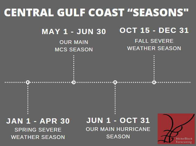
We are now moving into “MCS Season” across our area.
WHAT IS AN MCS?
A Mesoscale Convective System (MCS) is a complex and organized cluster of thunderstorms that covers a relatively large area, typically hundreds of miles across. MCSs are characterized by a distinct structure with multiple individual thunderstorms organized into a cohesive system.
They often form in regions with favorable atmospheric conditions, such as strong moisture and instability, along with a triggering mechanism like a frontal boundary or upper-level disturbance.MCSs can persist for several hours, sometimes lasting overnight, and can produce a variety of severe weather phenomena, including heavy rainfall, flash flooding, damaging winds, large hail, and even tornadoes. Due to their large size and longevity, MCSs can affect large regions.
This is the time of year where severe weather erupts across parts of Texas, Oklahoma, and Kansas, and clusters of storms avalanche into our area with a threat for heavy rain, lightning, and gusty wind. And the potential for hail and tornadoes is quite a bit lower. Not zero, but lower.
Notice how a lot of the seasons overlap, too.
Anyway!
The forecast for the next few days should be relatively calm.
On Thursday, the cold front will linger in the northern parts of our area before transitioning into a warm front and moving northward. This may bring isolated showers and thunderstorms, mainly north of I-20. Friday looks dry with an increase in moisture and warm air. We should remain dry through the weekend.
On Sunday night and through Monday, a cold front will approach from the west, bringing showers and thunderstorms mainly west of I-55. While there’s a chance of severe weather, confidence is low at this time.
REGIONAL DAY TO DAY FORECAST
Today: Patchy fog this morning. Sunny. Highs in the mid 80s. Northwest winds around 5 mph, becoming southwest around 5 mph this afternoon.
Tonight: Mostly clear. Patchy fog after midnight. Lows in the upper 50s. Southwest winds around 5 mph.
Thursday: Patchy fog in the morning. Mostly sunny. Highs in the mid 80s. East winds around 5 mph, becoming south in the afternoon.
Thursday Night: Partly cloudy in the evening, then becoming mostly cloudy. Lows around 60. South winds 5 to 10 mph.
Friday: Partly sunny. Highs in the mid 80s. Southeast winds 10 to 15 mph with gusts up to 30 mph.
Friday Night: Mostly cloudy. Lows in the mid 60s.
Saturday: Partly sunny. Highs in the lower 80s.
Saturday Night: Partly cloudy in the evening, then becoming mostly clear. Lows in the mid 60s.
Sunday: Mostly sunny. Highs in the mid 80s.
Sunday Night: Mostly clear in the evening, then becoming partly cloudy. Lows in the mid 60s.
Monday: Mostly sunny. A slight chance of showers and thunderstorms in the afternoon. Highs in the mid 80s. Chance of rain 10 percent.
Monday Night: Mostly cloudy with a slight chance of showers and thunderstorms. Lows in the mid 60s. Chance of rain 30 percent.
Tuesday: Mostly sunny. Highs in the mid 80s.


