Things are really calming down across southern Mississippi as high pressure takes over. That means the area will finally get to dry out after – what seems like – months of rainy days. In fact, as of right now, it looks like the area will see about five days in a row of dry weather, followed by a few more days of very-likely-to-remain-dry weather.
That is something we haven’t been able to say since last October. Pretty incredible.
Leaves plenty of time for me to keep tabs on the Tropics. And, well, the Tropics sure are getting an early start this year. There are two areas of interest out in the Tropical Atlantic – one in the Gulf and the other out toward Bermuda.
Thankfully, neither pose any imminent risk to southern Mississippi. And truly, neither pose much of a risk to develop into anything with ‘major’ impacts to anyone.
Day-by-Day Forecast
Today
Partly cloudy. Highs in the lower 80s. Southeast winds 10 to 15 mph.
Tonight
Partly cloudy. Lows in the mid 60s. East winds around 5 mph.
Saturday
Sunny. Highs in the upper 80s. East winds 5 to 10 mph.
Saturday Night
Partly cloudy. Lows in the lower 60s. South winds around 5 mph becoming light and variable.
Sunday
Mostly sunny. Highs in the upper 80s. East winds around 5 mph.
Sunday Night
Mostly clear. Lows in the lower 60s.
Monday
Sunny. Highs in the lower 90s.
Monday Night
Partly cloudy. Lows in the mid 60s.
Tuesday
Sunny. Highs in the lower 90s.
Tuesday Night
Mostly clear. Lows in the mid 60s.
Wednesday
Mostly sunny. Highs around 90.
Wednesday Night
Mostly clear. Lows in the upper 60s.
Thursday
Mostly sunny. Highs in the lower 90s.
In The Tropics
The National Hurricane Center is now monitoring two areas of interest. One in the Gulf and the other out toward Bermuda. Again, neither pose any risk to southern Mississippi. These are going to be storms that simply ‘pad the stats’ on the seasonal totals if they ever do develop into anything.
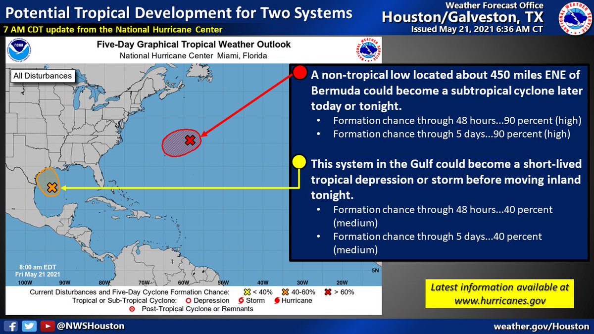
From the NHC:
Tropical Weather Outlook
NWS National Hurricane Center Miami FL
800 AM EDT Fri May 21 2021
For the North Atlantic…Caribbean Sea and the Gulf of Mexico:1. Showers and thunderstorms associated with a non-tropical low pressure area centered about 450 miles east-northeast of Bermuda have become better organized during the past several hours. The low has not yet acquired subtropical storm characteristics. However, if current trends continue advisories could be initiated on the system later today or tonight as it moves westward to west-southwestward to the northeast of Bermuda. Subsequently, the low is forecast to move northeastward into a more hostile environment by Saturday night or Sunday. Additional information on this low pressure area can be found in High Seas forecasts issued by the NOAA Ocean Prediction Center and forecast products, including a tropical storm watch, issued by the Bermuda Weather Service.
* Formation chance through 48 hours…high…90 percent.
* Formation chance through 5 days…high…90 percent.2. Recent satellite imagery suggests that a low-level circulation is forming associated with the mid- to upper-level disturbance over the western Gulf of Mexico. However, shower and thunderstorm activity remains disorganized. Environmental conditions are expected to be marginally conducive for development, and a short-lived tropical depression or storm could form before the disturbance moves inland over the northwestern Gulf coast tonight. Regardless of development, the system could produce heavy rainfall over portions of southeastern Texas and southwestern Louisiana during the next few days. Additional information on the rainfall and flooding potential can be found in products issued by your local National Weather Service Forecast Office.
Courtesy: nhc.noaa.gov
* Formation chance through 48 hours…medium…40 percent.
* Formation chance through 5 days…medium…40 percent.


Bet the one in the Gulf had a name by this time tomorrow.
*has … HAS a name …