There is a light at the end of this soggy tunnel. And I think we are starting to turn the corner and able to see it.
But first thing is first, today may be pretty rainy for some folks. The Weather Prediction Center has highlighted parts of the area with a Slight Risk for Flash Flooding.

That means that storms today may be able to drop a lot of rain over a short period of time. And given how wet the ground is, it won’t take much for storms to fill up the creeks, and gutters leading to localized flash flooding.
Down the ‘proverbial road’ a bit farther, drier days are ahead. For those that remember catching my forecasts on TV, you may recall that I used to do a 14-day forecast. The next 14 days for south Mississippi do actually feature some nearly fully and completely dry days.
But those are still more than five days away. And are likely not going to show up until we get into next week.
But! It is a start, though! And it does look like this overall pattern will start to bend a bit – not break – and allow some slightly drier days to sneak into the forecast by the time we get toward this weekend. Instead of 80-percent of 90-percent chances for rain, it may be a bit closer to 30- or 40-percent. Perhaps lower.
In fact, looking at the next seven days, estimated rainfall totals from the modal guidance show less than two inches of rain for the area.
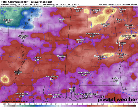
That means that next week – hopefully – mowing your yard won’t take scuba gear and Four-Wheel Drive to accomplish.
Day-to-Day Forecast
Today
Passing clouds with a 70-percent chance for afternoon storms. Highs in the mid 80s.
Tonight
Partly cloudy. Lows in the lower 70s.
Tuesday
Mostly cloudy with a 60-percent chance for shower and storms in the afternoon. Highs in the mid 80s.
Tuesday Night
Partly cloudy. Lows in the lower 70s.
Wednesday
Partly cloudy with afternoon storms possible. Highs in the upper 80s. The chance of rain 50-percent.
Wednesday Night
Partly cloudy. Lows in the lower 70s.
Thursday
Partly-to-mostly cloudy with more afternoon storms possible. Highs in the upper 80s. The chance of rain 50-percent.
Thursday Night
Partly cloudy. Lows in the lower 70s.
Friday
Passing clouds with afternoon storms less likely, but still possible. Highs in the upper 80s. The chance of rain 40-percent.
Friday Night
Partly cloudy. Lows in the lower 70s.
Saturday
Mostly sunny with a 30-percent chance of showers and thunderstorms. Highs in the lower 90s.
Saturday Night
Mostly clear. Lows in the lower 70s.
Sunday
Mostly sunny with a 30-percent chance of showers and thunderstorms. Highs in the mid 90s.


