Today will be another soggy day for south Mississippi. The WPC has pegged the area with a Slight Risk for Flash flooding again. So what you saw yesterday, is going to be pretty close to what you see again today.

Looking at the model guidance, there still looks to be a chance as we head through the end of this week for some drier-than-recently conditions to build into the area. And it will be a combination of factors that go into helping the area dry out a bit.
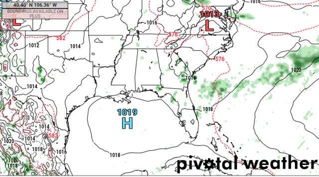
The first is the little “H” you see in the Gulf above. That is the “Little High Pressure That Could” that is going to try its very best to take over later this week. It won’t do a very good job, but it is going to try, really, really hard.
As it builds into the region, it will guide a plume of Saharan Dust around the Gulf and along the northern Gulf Coast.
This dust layer is also the reason that the tropics have been reasonably quiet during the past 10 days, and will be for the next 10 days (roughly), too.

So high pressure takes over (in a sense) and dust then dries out the air further. The combination of those two factors will help to ease back on the chance for rain starting Friday and through the weekend.
It won’t be completely dry. And, in fact, some areas will still see some rain here and there. But it will be drier than yesterday and today.
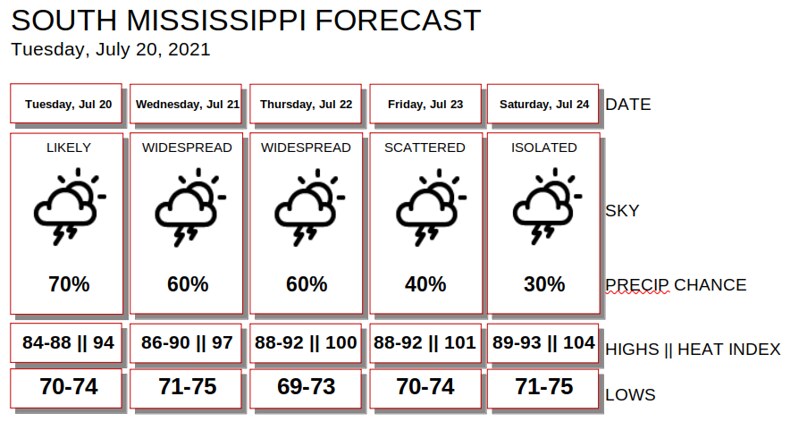
Daily Timeline
It looks like showers and storms will get moving pretty quickly today.

Tomorrow they may hold off until a bit after lunch, depending on how much we can work over the atmosphere today, but I’m – being honest here – not very confident that my forecast for tomorrow’s timeline will be very accurate.
Day-to-Day Forecast
Tuesday
Mostly cloudy with more showers and storms possible. Highs in the mid 80s. Rain chance around 70-percent
Tuesday Night
Partly cloudy with rain ending by midnight. Lows in the lower 70s.
Wednesday
Partly cloudy. Highs in the upper 80s. The chance of rain is around 60-percent.
Wednesday Night
Partly cloudy. Lows in the lower 70s.
Thursday
Passing clouds with more storms possible in the afternoon. Highs around 90. The chance of rain 40-percent.
Thursday Night
Partly cloudy. Lows in the mid 70s.
Friday
Partly cloudy with afternoon storms possible. Highs around 90. The chance of rain 40-percent.
Friday Night
Clearing skies. Lows in the low to mid 70s.
Saturday
Drier and mostly sunny with only a handful of afternoon storms. Highs in the lower 90s. The chance for rain looks to be around 30-percent.
Saturday Night
Mostly clear. Lows in the lower 70s.
Sunday
Sunny with a 30-percent chance of showers and thunderstorms. Highs in the lower 90s.
Sunday Night
Mostly clear. Lows in the mid 70s.
Monday
Mostly sunny with a 20-percent chance of showers and thunderstorms. Highs in the lower 90s.
Graphical Forecast