Looking at our regional outlook today, we see disorganized storms out in the northern Gulf with some pushing inland, impacting our coastal communities. Isolated thunderstorms are also forming across Alabama.
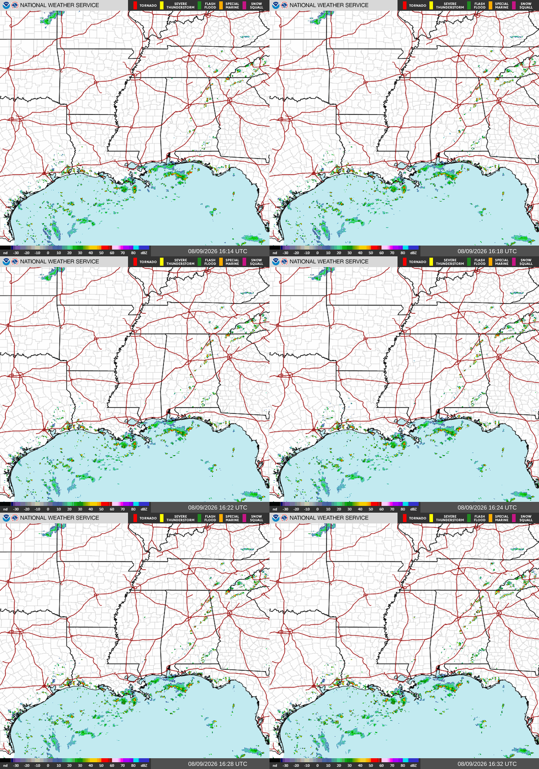
The scattered showers and mild pop-ups concentrated along coastal waters and immediate shorelines are driven by high humidity and temperature differences between the warming land and the water. Because we lack a strong frontal boundary or upper-level system to organize the instability, these showers remain widely scattered and non-severe. As a result, we can expect these pop-up storms to drift slightly inland with the sea-breeze front through the afternoon and fade away after sunset.
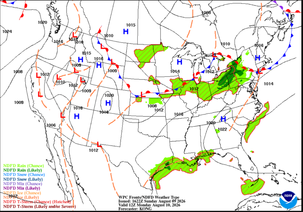
We see these coastal storms created by the sea breeze and marine convection along the northern Gulf coast from Texas to Florida. The 24-hour short-range forecast from the NWS shows the likelihood for rain and thunderstorms across the coast, impacting our area. These thunderstorms are not expected to be very severe, but can pop up quickly, especially as daytime heating draws in Gulf moisture in the afternoon.
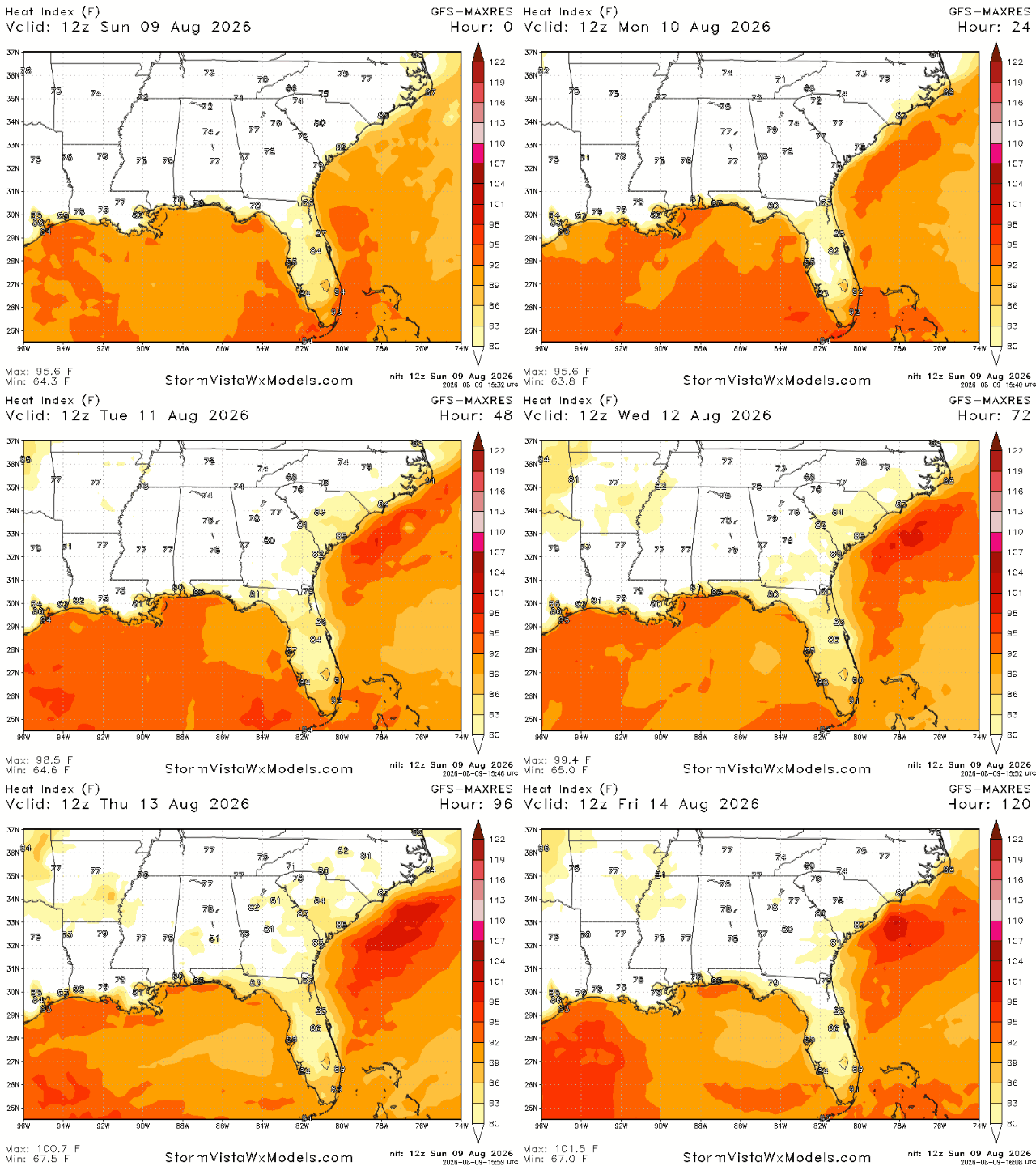
The heat index graphic above shows the expected “feels-like” temperatures across our region over the next five days. We’re seeing heat indices climb above 100 degrees across a majority of the area, making for some dangerously hot conditions. With August being one of the most brutally hot months across the South, be sure to stay hydrated, take frequent breaks from the heat, and find ways to stay cool throughout the day.
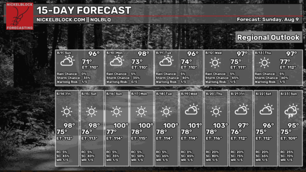
For our NickelBlock 15-day forecast, we see daily storm chances and very, very warm temperatures as we move further into August. This graphic predicts some sort of heat wave moving in early next week, so keep that on your radar as we get ready to send the kids back to school! Have a great week!
3 Day Travel Forecast
AIRPORTS
KIAH / KHOU (Houston) – Low delay risk due to weather.
KSHV (Shreveport) – Low risk for delays.
KBTR (Baton Rouge) – Mostly clear and sunny, so low risk for weather-related delays.
KMSY (New Orleans) – Low delay risk due to weather.
KJAN (Jackson) – Low delay risk from weather.
KBMH (Birmingham) – Chance for delays in the afternoons as storms build.
KMOB (Mobile) – Possible afternoon delays due to weather.
KATL (Atlanta) – Low delay risk due to weather.
KTLH (Tallahassee) – Possible delays from afternoon thunderstorms.
Highways
I-10: Afternoon thunderstorms are possible as you travel East or near the coast.
I-20: Mostly clear and hot; afternoon thunderstorm risk increases as you travel East.
I-49: Mostly warm and clear.
I-55 & I-59: Warm with potential showers.
I-65: Warm with potential showers/T-storms in the southern corridors.
I-75: Afternoon thunderstorms are to be expected and may turn severe at times.
3-Day City Forecast
Houston, TX: Sunday (9th): Warm with a slight chance of T-storms. High 92°F, low 80°F.
Monday (10th): Sunny with afternoon showers. High 91°F, low 80°F.
Tuesday (11th): Warm and sunny with potential afternoon showers. High 94°F, low 80°F.
Shreveport, LA: Sunday (9th): Hot with a 20% chance of T-storms. High 96°F, low 77°F.
Monday (10th): Hot and clear. High 96°F, low 78°F.
Tuesday (11th): Warm and sunny, mostly clear. High 97°F, low 79°F.
Baton Rouge, LA: Sunday (9th): Partly cloudy with a slight chance of T-storms. High 95°F, low 76°F.
Monday (10th): Sunny with a 50% chance for afternoon showers/T-storms. High 93°F, low 76°F.
Tuesday (11th): Warm and sunny with potential afternoon showers. High 94°F, low 77°F.
New Orleans, LA: Sunday (9th): Slight chance of T-storms in the afternoon. High 88°F, low 78°F.
Monday (10th): Afternoon showers with a clear evening. High 90°F, low 79°F.
Tuesday (11th): Potential afternoon showers, partly cloudy. High 91°F, low 79°F.
Jackson, MS: Sunday (9th): 40% chance of T-storms, mostly clear evening. High 94°F, low 75°F.
Monday (10th): Sunny with a 30% chance for afternoon showers. High 96°F, low 75°F.
Tuesday (11th): Warm and sunny with 20% chance of afternoon showers. High 95°F, low 76°F.
Birmingham, AL: Sunday (9th): Hot with T-storms, mostly cloudy evening. High 91°F, low 74°F.
Monday (10th): Partly sunny with afternoon T-storms. High 91°F, low 75°F.
Tuesday (11th): Afternoon T-storms and showers likely. High 90°F, low 75°F.
Mobile, AL: Sunday (9th): Afternoon T-storms likely. High 93°F, low 77°F.
Monday (10th): 50% chance for afternoon T-storms. High 91°F, low 77°F.
Tuesday (11th): Warm and sunny with potential afternoon showers. High 92°F, low 78°F.
Atlanta, GA: Sunday (9th): Hot with a slight chance of T-storms. High 92°F, low 74°F.
Monday (10th): Mostly sunny with a 30% chance for afternoon showers. High 91°F, low 74°F.
Tuesday (11th): Potential afternoon T-storms, then mostly clear. High 91°F, low 74°F.
Tallahassee, FL: Sunday (9th): Hot with potential afternoon T-storms. High 93°F, low 75°F.
Monday (10th): Sunny with a 30% chance for afternoon T-storms. High 94°F, low 75°F.
Tuesday (11th): Warm and sunny with potential afternoon T-storms. High 96°F, low 75°F.


