We are still looking at a chance for storms today and tomorrow. Today’s storms will be here and there and should remain pretty isolated. The storms tomorrow should be more widespread and a bit more potent, too.
The Storm Prediction Center continues to monitor the area with the potential for severe weather. Today the highest risk for storms will be to the northwest, while tomorrow the highest risk for severe weather will be plopped across our area.
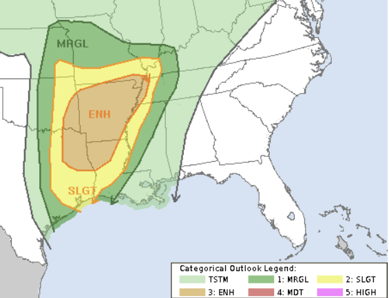
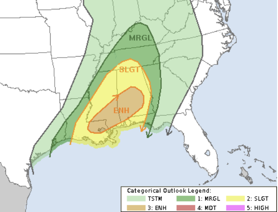
The main concern with storms will be heavy rain, lightning, gusty wind, small hail and the potential for a few tornadoes. The main timeline for the strongest storms will be between about 11a on Tuesday and 11p on Tuesday. There is a chance that a few storms may linger around overnight, but right now the severe weather risk should be over by midnight. That means any lingering storm could be noisy, but wouldn’t pose a risk for tornadoes or wind gusts exceeding 60mph.
After all the riff-raff exits east, we dry out for a few days. Temperatures will be seasonable, too, so no big shot of cold and no major warm up expected.
DAY TO DAY FORECAST
Today
Cloudy. Areas of dense fog in the morning. A slight chance of showers in the morning, then a chance of showers and thunderstorms in the afternoon. Highs in the upper 70s. Chance of rain 40 percent.
Tonight
Mostly cloudy with a chance of showers and thunderstorms. Near steady temperature in the upper 60s. Chance of rain 30 percent.
Tuesday
Cloudy with storms likely. Some severe. Highs in the mid 70s. South winds 10 to 15 mph with gusts up to 25 mph. Chance of rain 80 percent.
Tuesday Night
Mostly cloudy with lingering showers and thunderstorms possible. Lows in the upper 50s. Chance of rain 40 percent.
Wednesday
Morning clouds with a few lingering shower possible. Highs in the upper 60s. Chance for rain 30 percent.
Wednesday Night
Partly cloudy. Cooler with lows in the mid 40s.
Thursday
Sunny, cooler with highs in the upper 50s.
Thursday Night
Clear. Lows in the mid 30s.
Friday
Sunny. Highs in the mid 50s.
Friday Night
Clear. Lows in the mid 30s.
Saturday
Sunny. Highs in the lower 60s.
Saturday Night
Mostly clear. Lows in the lower 40s.
Sunday
Mostly sunny. Highs in the mid 60s


