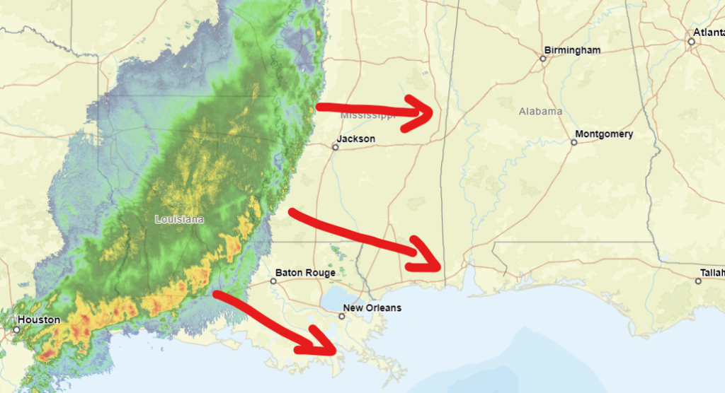
A decaying MCS is likely going to plow through the area as we move through the morning. This is an example of the “MCS season” post I made the other day. These clusters of storms that develop across parts of the Plains eventually find their way to the Gulf Coast.
The good news? Severe weather is unlikely. Can’t rule it out, but it isn’t likely.
The bad news? These storms can still be rowdy with heavy rain, lightning, wind gusts up to 50mph, and small hail.
Based on radar trends I would estimate the cluster of storms should reach I-55 around 8am and I-59 around 10am. And the alabama border around 12p.
But, honestly, when it comes to the forward speed of these MCSs I’ve learned that they don’t often maintain the same forward speed with any regularity. At times they’ll be moving 40mph, then slow down in some sections to just 10mph, and then other sections speed up. It is a bit of a chaotic system on the leading edge.
So, if the rain shows up a bit earlier or later, don’t be too surprised.
The storms should kick through and work over the atmosphere pretty well. But we may leave the door open for a few isolated showers to try to redevelop this afternoon and evening. But I think that’s a pretty low-end risk.
We may have another round of rain try to move through tomorrow, but the model guidance hasn’t been handling that risk very well at all, so I’ll leave it around a 30-percent shot.
After that we dry out and should remain – mostly – dry through the week. And by this weekend we could be pushing 90 degrees in some spots.
REGIONAL DAY TO DAY FORECAST
Today: Partly sunny with two potential rounds of rain – one in the morning and some more possible this afternoon. Highs in the lower 80s. Temperature falling into the upper 70s this afternoon. South winds 10 to 15 mph with gusts up to 25 mph. Chance of rain 90 percent.
Tonight: Showers likely with a chance of thunderstorms. Lows in the mid 60s. South winds 10 to 15 mph, diminishing to around 5 mph after midnight. Chance of rain 30 percent.
Tuesday: Partly sunny in the morning, then clearing. A chance of showers with a slight chance of thunderstorms. Highs in the mid 80s. Southwest winds around 5 mph. Chance of rain 30 percent.
Tuesday Night: Mostly clear in the evening, then becoming partly cloudy. Patchy fog after midnight. Lows in the lower 60s. South winds around 5 mph.
Wednesday: Mostly sunny. Patchy fog in the morning. A slight chance of showers and thunderstorms in the afternoon. Highs in the upper 80s. Southeast winds 5 to 10 mph. Chance of rain 20 percent.
Wednesday Night: Partly cloudy. Lows in the mid 60s.
Thursday: Mostly sunny. Highs in the upper 80s.
Thursday Night: Partly cloudy. Lows in the mid 60s.
Friday: Partly sunny. A slight chance of showers and thunderstorms in the afternoon. Highs in the mid 80s. Chance of rain 20 percent.
Friday Night: Partly cloudy. Lows in the lower 60s.
Saturday: Mostly sunny. A slight chance of showers and thunderstorms in the afternoon. Highs in the upper 80s. Chance of rain 20 percent.
Saturday Night: Partly cloudy. Lows in the lower 60s.
Sunday: Mostly sunny. Highs in the upper 80s.


