Just a quick breakdown this morning as I’m running a bit behind and you guys are probably more interested in how the weather will impact weekend plans than you are interested in reading about the quirks of the atmosphere!
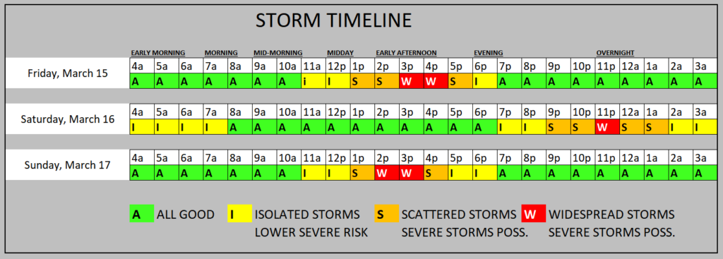
In short: I don’t think USM plays much baseball this afternoon and I think anyone with outdoor plans this afternoon is likely to get a bit soggy. Tomorrow, it looks like any rain will be a bit later at night. And Sunday it looks like an early afternoon chunk of storms.
Severe weather is possible with each go-around, but I think the best bet for severe weather is likely going to be today (with hail and gusty wind as the main concern) and Sunday (wind, hail and a few brief tornadoes).
That said, I think today, across parts of Louisiana and into coastal Mississippi we may have a brief window for a tornado or two this afternoon / evening as storms develop back to the west along the tail-end of the line.
REGIONAL DAY TO DAY FORECAST
Today: Mostly cloudy. Patchy fog this morning. A chance of showers and thunderstorms this morning, then showers likely with a slight chance of thunderstorms this afternoon. Highs around 80. South winds 10 to 15 mph with gusts up to 25 mph. Chance of rain 70 percent.
Tonight: Mostly cloudy with a slight chance of thunderstorms. A chance of showers, mainly in the evening. Patchy fog after midnight. Lows in the lower 60s. Southeast winds 5 to 10 mph, becoming northwest after midnight. Chance of rain 50 percent.
Saturday: Mostly cloudy in the morning, then partly sunny with a chance of showers with a slight chance of thunderstorms in the afternoon. Highs around 80. North winds around 5 mph. Chance of rain 30 percent.
Saturday Night: Mostly cloudy. A chance of showers and thunderstorms after midnight. Lows in the lower 60s. Southwest winds around 5 mph. Chance of rain 40 percent.
Sunday: A chance of thunderstorms. Showers. Highs in the lower 70s. Northeast winds 5 to 10 mph. Chance of rain 90 percent.
Sunday Night: Mostly cloudy with a chance of thunderstorms with a slight chance of showers in the evening, then partly cloudy after midnight. Cooler with lows in the upper 40s. Chance of rain 30 percent.
Monday: Sunny. Highs in the upper 60s.
Monday Night: Mostly clear. Cooler with lows in the upper 30s.
Tuesday: Mostly sunny. Highs in the lower 60s.
Tuesday Night: Partly cloudy. Lows in the lower 40s.
Wednesday: Mostly sunny. Highs in the lower 70s.
Wednesday Night: Partly cloudy. Lows in the upper 40s.
Thursday: Partly sunny with a slight chance of showers in the morning, then mostly cloudy with a chance of showers with a slight chance of thunderstorms in the afternoon. Highs in the lower 70s. Chance of rain 40 percent.


