
We have two more rounds of storms that will make their way through Mississippi over the weekend that will have some strong to severe possible. Stuck between two fronts means that most of the northern areas will see rain and not much else while areas closer to the coast will likely see more of the severe weather.

How severe? Looking at the outlook above and the reports from the SPC, nothing crazy. Our main concern for the storms will be some strong wind gusts, and as the system moves eastward towards Florida, possibly some tornadic cells. Overall, it looks like mostly a rain and wind event for much of the deep south tomorrow.
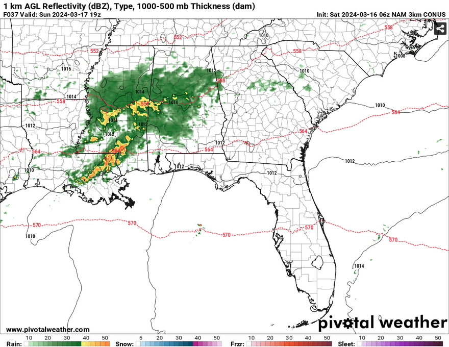
The first round of storms looks to arrive overnight from midnight onward Saturday into Sunday. Most of these look scattered in eastern Mississippi with more of the rain on the western end. As the sun comes up, we’ll see the cold front in northern Mississippi start to inch further south and pull in some moisture and rain will start in central and northern Mississippi. The stationary front and low pressure system will move east and bring with it some of the stronger to severe storms starting in the early afternoon (from around 1-5pm). Most of our rainfall will happen in the afternoon with up to 1.5″ possible. Before the cold front finally moves out, one more small shot of rain may be possible for coastal Mississippi overnight.
After all that, we’ll see temperatures drop into the 60s for the high on Monday. A significant trough in the upper levels will bring in cooler and drier weather which may even bring in some possible frost overnight into Tuesday. Expect a cooler but blustery day on Monday as we’ll likely see some 20+ mph wind gusts throughout the day.
[wpcode id=”41179″]
Regional Day-to-Day Forecast
Today – A slight chance of showers in the afternoon. Partly sunny, with a high in the mid 70s. North northeast wind around 5 mph. Chance of precipitation is 20%.
Tonight – A 50 percent chance of showers and thunderstorms, mainly after midnight. Mostly cloudy, with a low in the upper 50s. Calm wind becoming northwest around 5 mph. New rainfall amounts between a tenth and quarter of an inch, except higher amounts possible in thunderstorms.
Sunday – Showers and possibly a thunderstorm. High in the mid 60s. North wind around 5 mph. Chance of precipitation is 90%. New rainfall amounts between a half and three quarters of an inch possible.
Sunday Night – A slight chance of thunderstorms before sunset. Mostly cloudy, then gradually becoming mostly clear, with a low in the mid 40s. North wind 5 to 10 mph. Chance of precipitation is 10%.
Monday – Sunny, with a high in the low 60s. North wind 10 to 15 mph, with gusts as high as 25 mph.
Monday Night – Areas of frost starting in the early morning. Otherwise, mostly clear, with a low in the low 30s. North wind 5 to 15 mph, with gusts as high as 25 mph.
Tuesday – Widespread frost, mainly after sunrise. Otherwise, sunny, with a high in the low 60s. North northeast wind around 5 mph becoming calm in the morning.
Tuesday Night – Partly cloudy, with a low in the low 40s. West southwest wind around 5 mph.
Wednesday – Mostly sunny, with a high in the low 70s. West wind around 5 mph.
Wednesday Night – Mostly cloudy, with a low in the upper 40s.
Thursday – A 40 percent chance of showers. Mostly cloudy, with a high in the mid 60s.
Thursday Night – A 40 percent chance of showers and thunderstorms. Mostly cloudy, with a low in the low 50s.
Friday – A 30 percent chance of showers and thunderstorms. Partly sunny, with a high in the low 70s.
[wpcode id=”41149″]


