It was toasty one today.
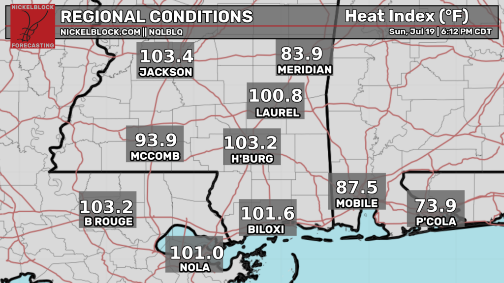
Some areas have been significantly cooled off by rain and storms. This will likely not be the case for tomorrow. Much of the area will likely see highs in the upper 90s with little relief from clouds or rain. Make sure to drink plenty of fluids and take frequent breaks in the AC if you must be outside.
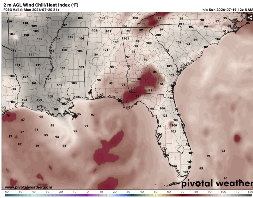
Heat indexes may exceed 110. As such, the National Weather service has issued a heat advisory for much of the lower Mississippi Valley. There is a slight chance of storms across the entire region for some isolated storms but most locations will just remain very humid but dry.
The bigger story though is tropical depression two sitting in the gulf.
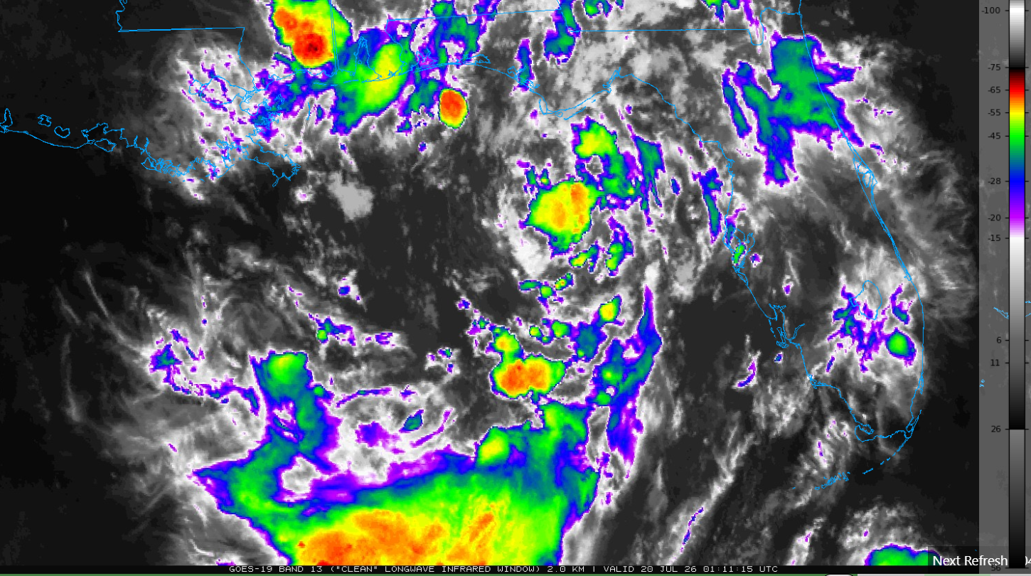
This is a slow moving system that isn’t doing much as of now. It is expected to slowly move west-northwest in the coming days potential clipping the central Gulf coast.
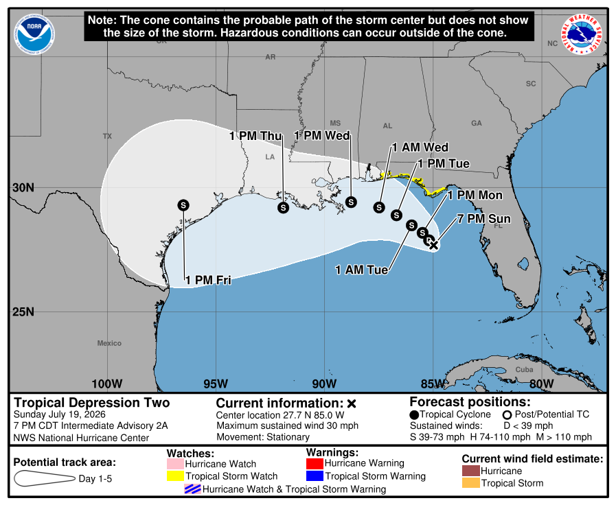
Right now the exact track and intensity are still very uncertain. It doesn’t appear that it’ll strengthen too much but that could quickly change.
What we do know is that it will likely become at least a tropical storm as it glides west. The Florida panhandle may start to see tropical storm conditions as soon as tomorrow night. Tropical storm watches have already been issued along the coast in this area. Areas further west will see impacts after this.
Flooding looks to be the main threat by late week across Louisiana, southern Mississippi, and southern Alabama. Now is the time to start preparing if you live in this region and haven’t already started.
Anyone along the Gulf should closely monitor the forecast over the coming days. We will provide more information as the forecast becomes clearer.
Airport Forecasts
Houston (KIAH/KHOU)- No issues anticipated. Should be dry and sunny.
Shreveport (KSHV)- Very hot but no storms or rain. Should be all good for flying.
Baton Rouge (KBTR)- Mostly fine. Can’t rule out an isolated storm Tuesday afternoon. This could lead to a brief delay for lightning or microbursts.
New Orleans (KMSY)- Afternoon and evening thunderstorms possible each of the next two days. This may lead to some quick delays for lightning or downbursts.
Jackson (KJAN)- Very hot but no issues expected for flying.
Mobile (KMOB)- Storms possible each of the next two afternoons (more likely on Tuesday). This may cause some lightning or downdraft related delays.
Birmingham (KBMH)- A low chance for some storms tomorrow afternoon and evening. This could pose a threat for some lightning or microburst delays.
Tallahassee (KTLH)- Waves of on and off thunderstorms for the next few days. Some longer delays are possible for lightning and downbursts. This is being affected by tropical depression two which is off the coast to the south.
Atlanta (KATL)- There is a low chance for a storm or two tomorrow afternoon. This could lead to a quick delay for lightning or downdrafts. Most flights should be unaffected.
Highways
I-10 – Mostly fine. There will probably be some showers or storms in the Florida panhandle associated with the tropical system. We also can’t rule out a very isolated storm further west tomorrow during the late afternoon but most places will be dry.
I-20 – A couple very isolated storms are possible throughout the region during the dinner hour tomorrow but the vast majority of locations will be dry.
I-49 – Should be dry and sunny.
I-55 and I-59 – At least 99% of the route will be clear but there may that one spot that gets very heavy rain for a couple miles.
I-65 – A couple isolated storms are possible across the length of Alabama. Make sure to slow down when encountering water on the roadway.
I-75 – A few storms possible across Georgia but nothing major. Watch out for ponding on pavement.
City Forecasts
Houston, TX
Tonight- Mostly clear with a low in the mid 70s. Dry.
Tomorrow- Sunny with a high in the mid to upper 90s. No rain.
Tuesday- Sunny with a high in the upper 90s. No precipitation.
Shreveport, LA
Tonight- Clear with a low in the mid 70s. No rain.
Tomorrow- Sunny with a high in the upper 90s. Dry.
Tuesday- Sunny with a high in the low 100s. No precipitation.
Baton Rouge, LA
Tonight- Mostly clear with a low in the upper 70s. No rain.
Tomorrow- Sunny with a high in the upper 90s. Dry.
Tuesday- Sunny with a high in the upper 90s. A storm or two possible in the afternoon.
New Orleans, LA
Tonight- Partly cloudy with a low in the low 80s. No rain.
Tomorrow- Increasing clouds with a high in the mid 90s. Isolated thunderstorms possible in the afternoon and evening.
Tuesday- Increasing clouds with a high in the mid 90s. Scattered afternoon thunderstorms possible.
Jackson, MS
Tonight- Mostly clear with a low in the mid 70s. Dry.
Tomorrow- Sunny with a high in the upper 90s. No rain.
Tuesday- Sunny with a high in the upper 90s. No Precipitation.
Birmingham, AL
Tonight- Mostly cloudy with fog possible. Dry with a low in the mid 70s.
Tomorrow- Scattered afternoon thunderstorms possible. Mostly sunny with a high in the mid 90s.
Tuesday- Sunny with a high in the mid 90s. Dry.
Mobile, AL
Tonight- Storms die off after sunset. Decreasing clouds with a low in the mid 70s.
Tomorrow- Increasing clouds with a high in the mid 90s. Isolated afternoon storms possible.
Tuesday- Scattered afternoon storms likely. Increasing clouds with a high in the mid 90s.
Tallahassee, FL
Tonight- Isolated showers and storms possible. Partly cloudy with a low in the mid 70s.
Tomorrow- Widespread storms likely. Mostly cloudy with a low in the upper 80s.
Tuesday- Widespread storms likely. Mostly cloudy and windy with a high in the upper 80s.
Atlanta, GA
Tonight- Decreasing clouds with a low in the mid 70s. Dry.
Tomorrow- Isolated afternoon thunderstorms possible. Mostly sunny with a high in the low 90s.
Tuesday- Mostly sunny with a high in the low 90s. No rain.


