Hello everyone, there will be a strong cold front will be arriving to the SE Mississippi and SW Alabama in the late afternoon and early evening hours for a chance rainy weather. With the cooler air mass from the northeast, it will bring cooler temperatures than normal for the next few days. In the morning, it will be partly cloudy with a low temperature in the low 70s. In the afternoon, it will be mostly cloudy to scattered showers and thunderstorms with a high temperature in the low 90s. The dew point temperatures will be expected to be in the upper 60s to low 70s throughout the day.
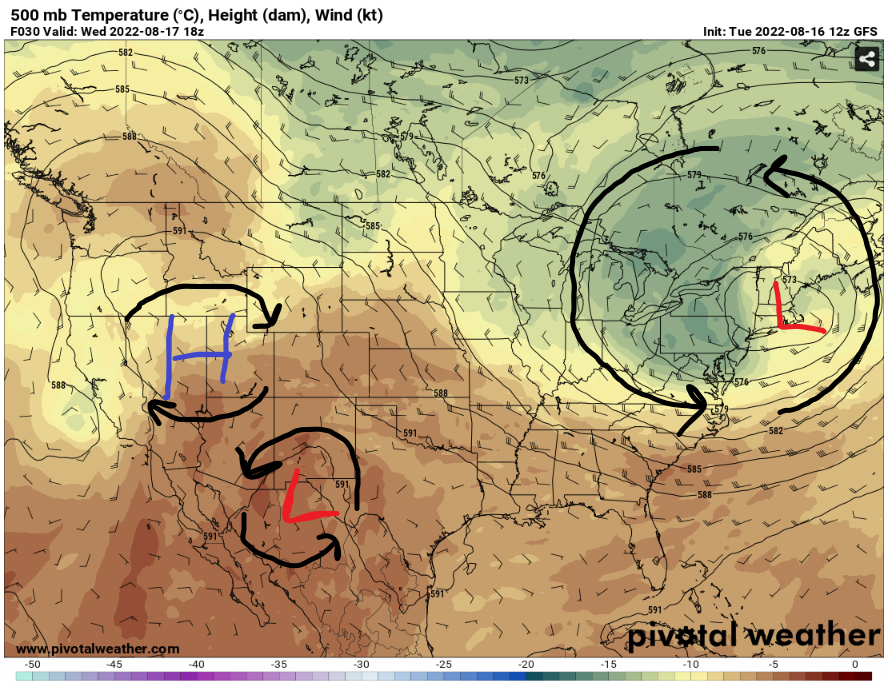
With the strong low-pressure system and the trough will dip down to the southeast for another change of the weather pattern. The high-pressure system is expected to go to the northwest to not bring any hotter and drier weather in the southeast. Stay dry out there because in the next few days, there will be a massive increase in precipitation from this cold front and Jet Stream winds moving storms from the Great Plains by coming down to SE Mississippi and SW Alabama.
Here is a visual update on the HRRR Reflectivity, as the storms are being move from the Jet stream winds to northern Mississippi and Alabama in the morning then coming down south later in the day. Even though the storms might be losing its strength throughout the day, it can redevelop with the cold front is nearby in northern Mississippi and Alabama with rich moisture from the Gulf of Mexico.
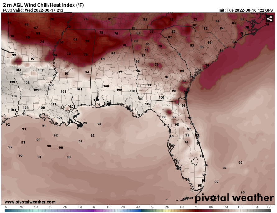
Around 4pm, the heat index values will reach up to upper 90s to low 100s in SE Mississippi and SW Alabama. Depending on the arrival or redevelopment of these storms will determine the heat index values because the massive difference in heat index values in the northern part of the states. These temperatures values shows that the storms will happen late afternoon and evening.
Day to Day Forecast
Wednesday
Mostly Sunny, with a 50% chance of scattered showers and thunderstorms in the afternoon. With a high temp in the low 90s and a low temp in the low 70s. A north wind around 5 mph.
Thursday
Mostly cloudy and rainy, with an 80% chance of widespread showers and thunderstorms in the afternoon. With a high temp in the mid 80s and a low temp in the low 70s. A calm wind up to 5 mph to the west throughout the day.
Friday
Rainy, with an 80% chance of widespread showers and thunderstorms in the afternoon. With a high temp in the low 80s and a low temp in the upper 60s. A Calm wind up to 5 mph to the west throughout the day.
Saturday
Mostly sunny, with an 70% chance of widespread showers and thunderstorms in the afternoon. With a high temp in the mid 80s and a low temp in the low 70s. A Calm wind up to 5 mph to the southwest throughout the day.
Sunday
Mostly sunny, with an 50% chance of scattered showers and thunderstorms in the afternoon. With a high temp in the mid 80s and a low temp in the low 70s. A Calm wind up to 5 mph to the southwest throughout the day.
Monday
Mostly sunny, with an 50% chance of scattered showers and thunderstorms in the afternoon. With a high temp in the mid 80s and a low temp in the low 70s. A Calm wind up to 5 mph to the southwest throughout the day.
Tuesday
Partly cloudy, with an 50% chance of scattered showers and thunderstorms in the afternoon. With a high temp in the upper 80s and a low temp in the low 70s. A Calm wind up to 5 mph throughout the day.


