Good morning! After being back in Louisiana for a week for school, I am very ready for the temperatures to start cooling off again. While this won’t be happening right away, we’re looking better for the second half of this work week.
Starting with today, we will come down from the high heat, though temperatures will still hover around 95F for most of the area, with heat indices reaching 105F in some areas. This probably isn’t “heat advisory” quality, so we should be free of any watches or warnings, like we saw in Vicksburg yesterday.

The NWS Blend of Models shows a corridor of higher heat in our area, and that area between Jackson and Hattiesburg is where we expect to see the highest heat indices.
Temperatures won’t be as high in areas with storms, though, as numerous storms are possible. The HRRR computer model does show some strong storms popping up in the area this afternoon.

The Storm Prediction Center has the entire region outlined in a Marginal Risk of severe thunderstorms, which indicates that some storms pay produce strong downbursts, or strong wind gusts. The severe weather threat is not widespread or particularly high, but we should be on the lookout for some damaging wind gusts.

Though the East Coast is entering a troughing phase, bringing cooler and wetter weather, we have to deal with the ridge for one more day before the boundary makes a push further South.
Some forcing from the boundary will trigger storms, though, even though it hasn’t passed through our region yet. With tropical moisture in place, we’re going to have to watch out for heavy rains. Most portions of the area are under a Marginal Risk of flash flooding, but that’s what we’ve been seeing over the past few weeks.

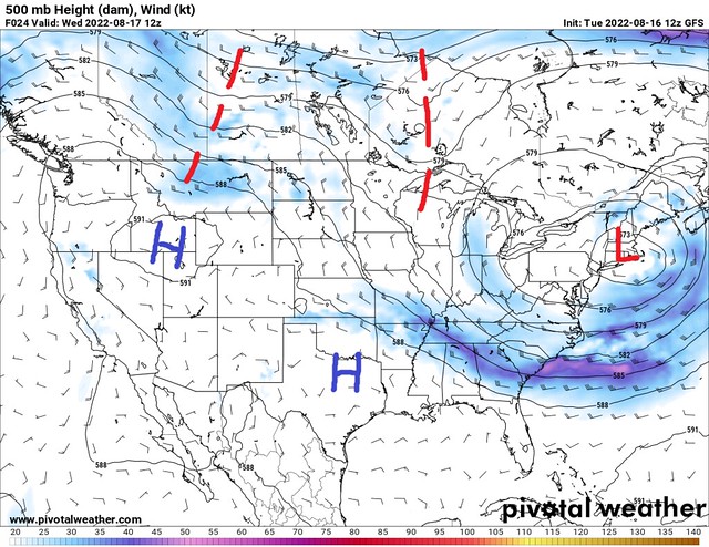
This next map is taking a look at the upper-air pattern on Friday morning. Finally, lower heights are showing up over our area, and we should see a significant cooldown because of it. This disturbance will also bring more rain chances across the area.
Speaking of the heavy rain, we have a good shot at seeing significant rainfall over these next 5 days, especially tomorrow and Friday.

A large swath of 2-3” of rain is expected, especially on the Southern half of the region. Flooding will remain a real possibility across Southern Mississippi.
However, this cooler and wetter pattern is going to be short-lived, as a High Pressure returns to the region at the end of this weekend. The subtropical High is expected to strengthen, which will act to block the cooler weather, keeping it further North.

We do have warmer weather (closer to average) to look forward to, though leftover boundaries will keep frequent storms through the weekend even as the heat increases. The chances will be lower, but still present until the end of the forecast period.
Day-to-Day Forecast
Today
Partly cloudy, with a 40-percent chance of afternoon thunderstorms. Some may be strong. Highs in the mid-90s. The heat index may reach 105F.
Tomorrow
Cloudy, with an 80-percent chance of rain and thunderstorms. Heavy rain may occur. Highs in the mid-80s.
Friday
Cloudy, with a 70-percent chance of rain and thunderstorms. Heavy rain may occur. Highs in the low-80s.
Saturday
Mostly cloudy, with a 60-percent chance of afternoon thunderstorms. Highs in the mid-80s.
Sunday
Partly cloudy, with a 50-percent chance of afternoon thunderstorms. Highs in the mid-80s.
Monday
Partly cloudy, with a 60-percent chance of afternoon thunderstorms. Highs in the upper-80s.
Tuesday
Partly cloudy, with a 50-percent chance of afternoon thunderstorms. Highs in the upper-80s.


