After a long, rainy week, we’ll see the most seasonable, boring week in terms of weather, and that’s not a bad thing!

Our current setup in the atmosphere is a pretty amplified trough-ridge-trough. A strong trough in the Pacific is developing meanwhile two ridges are forming in the Rockies and the western Gulf giving us a pretty stout wave across the middle of North America. Looking at the graphic above, the Gulf high pressure system is going to push one trough further east towards the mid-Atlantic states and keep us dry through the middle of the week. However, by the end of the week, the trough in the Pacific will move across the mountains and bring another possible storm system along with it.
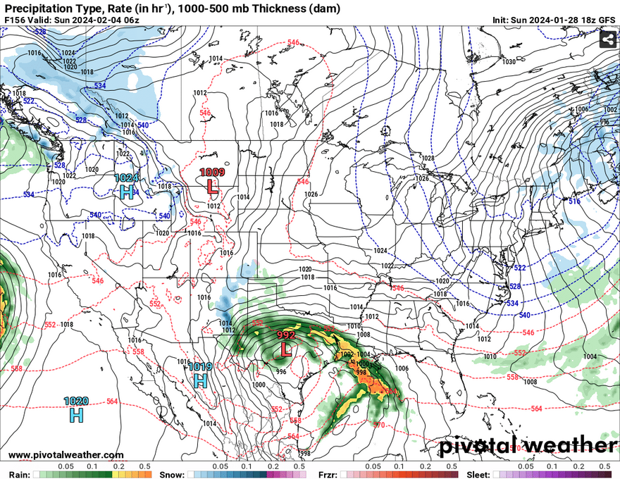
Our dry spell will last several days before we see rain again, and the rain will come back fairly hard. Texas, Louisiana, and many areas in the southern and central parts of Mississippi and Alabama may likely get some of the rain before the system moves towards the Gulf. Both the GFS and Euro agree on the direction of the low’s trajectory mainly due to a strong high pressure system in the eastern Great Plains. While this is still about a week out, if you have any plans for the weekend, keep in mind the rain may affect what you can do. The SPC shows fairly low confidence in this system producing anything severe, but some thunderstorms are still possible.
During the week itself, temperatures will be fairly consistent during the day topping out around the low to mid 60s starting Tuesday into Friday. Conditions will be fairly dry with clouds intermittent during the day and night. Winds will shift to the South as the trough begins to move in around Thursday until the system moves out.
[wpcode id=”41179″]
Regional Day-to-Day Forecast
Tonight – Partly cloudy, with a low in the upper 30s. North northwest wind 5 to 10 mph, with gusts as high as 20 mph.
Monday – Sunny, with a high in the upper 50s. North northwest wind around 5 mph.
Monday Night – Partly cloudy, with a low in the mid 30s. North northwest wind around 5 mph becoming calm in the evening.
Tuesday – Mostly sunny, with a high in the mid 60s. West southwest wind 5 to 10 mph.
Tuesday Night – Mostly clear, with a low in the low 40s. Southwest wind around 10 mph becoming northwest after midnight.
Wednesday – Sunny, with a high in the low 60s. North wind 5 to 10 mph, with gusts as high as 20 mph.
Wednesday Night – Partly cloudy, with a low in the mid 30s. North wind around 5 mph becoming east northeast after midnight.
Thursday – Mostly sunny, with a high near 60. East northeast wind around 5 mph becoming south in the afternoon.
Thursday Night – Partly cloudy, with a low in the upper 30s. South wind around 5 mph becoming calm in the evening.
Friday – Mostly sunny, with a high in the mid 60s.
Friday Night – Partly cloudy, with a low in the mid 40s.
Saturday – A 20 percent chance of rain. Mostly sunny, with a high in the mid 60s.
Saturday Night – Rain likely. Mostly cloudy, with a low in the mid 40s. Chance of precipitation is 60%.
Sunday – A 50 percent chance of rain. Partly sunny, with a high in the low 60s.
[wpcode id=”41149″]


