Current Conditions
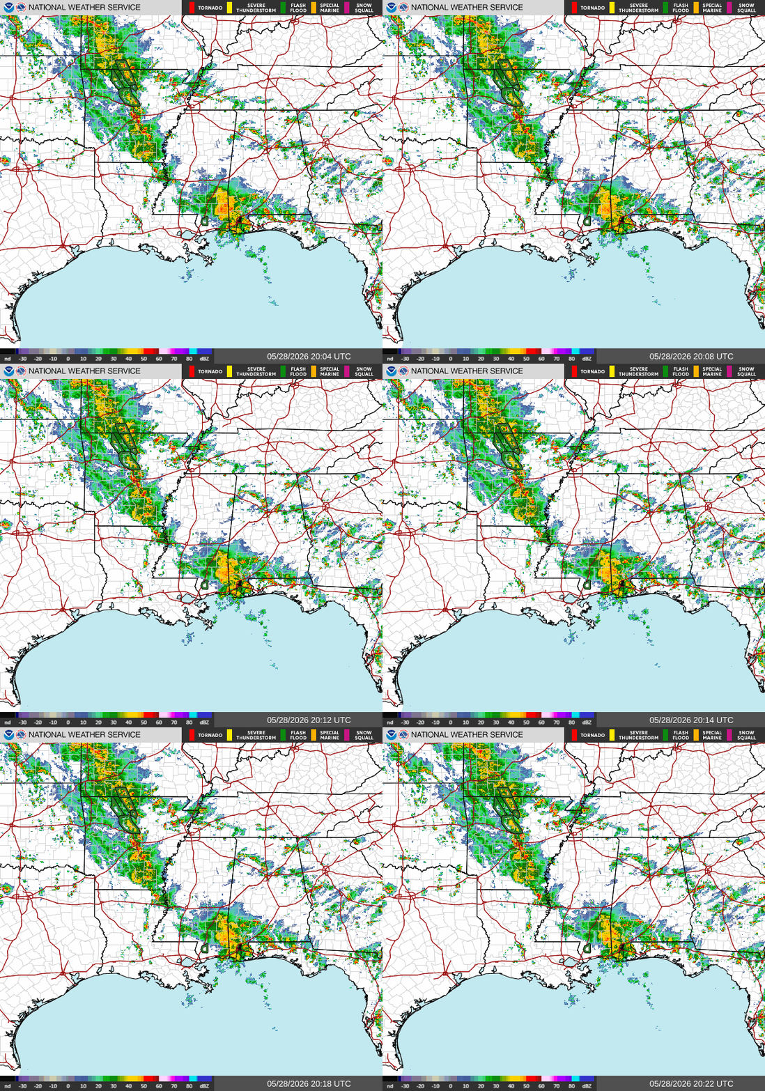
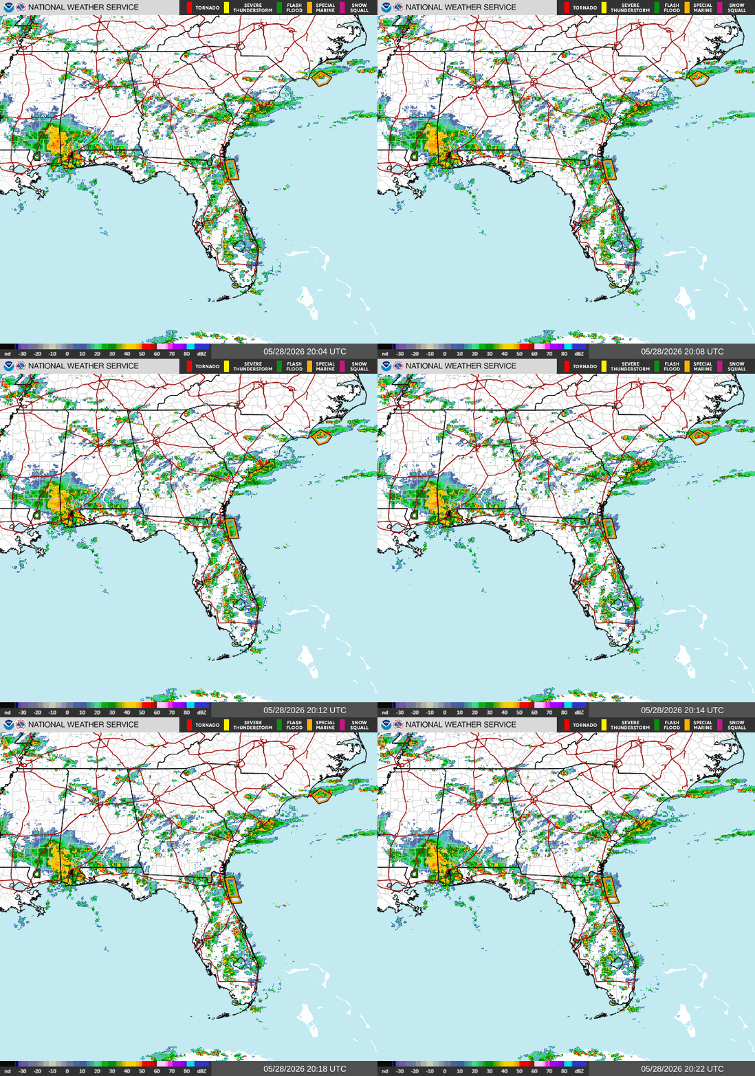
Currently, we’re seeing storms and rain throughout the Southern region. The precipitation is pushing North in AR, MS, and AL. Northern AR has active alerts for flash flooding. In FL, the precipitation is moving east. There is a special marine warning just off the coast of East FL. Winds are coming out of the Southwest, and with the warm, moist air, fueling these storms.
Tonight
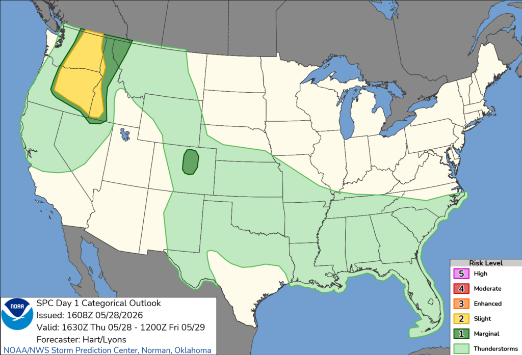
The SPC has the entire Southern region under a thunderstorm risk. This will also linger into tomorrow.
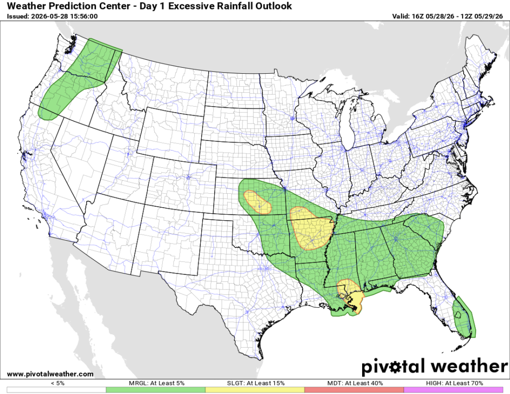
Southern MS and part of Southern LA are expecting excessive rainfall throughout the rest of today into tomorrow morning. Keep up with your area for alerts of flash flooding and/or flooding.
Extended Regional Outlook
The CPC outlook has the Southern region near normal, while our precipitation is mostly above normal.


Below, there are three different models suggesting outcomes for next week. All three look fairly similar: a trough near Baja California and a high-pressure system somewhere in the Gulf. An outcome here could mean normal to slightly above temperatures in the South with the same precipitation conditions.
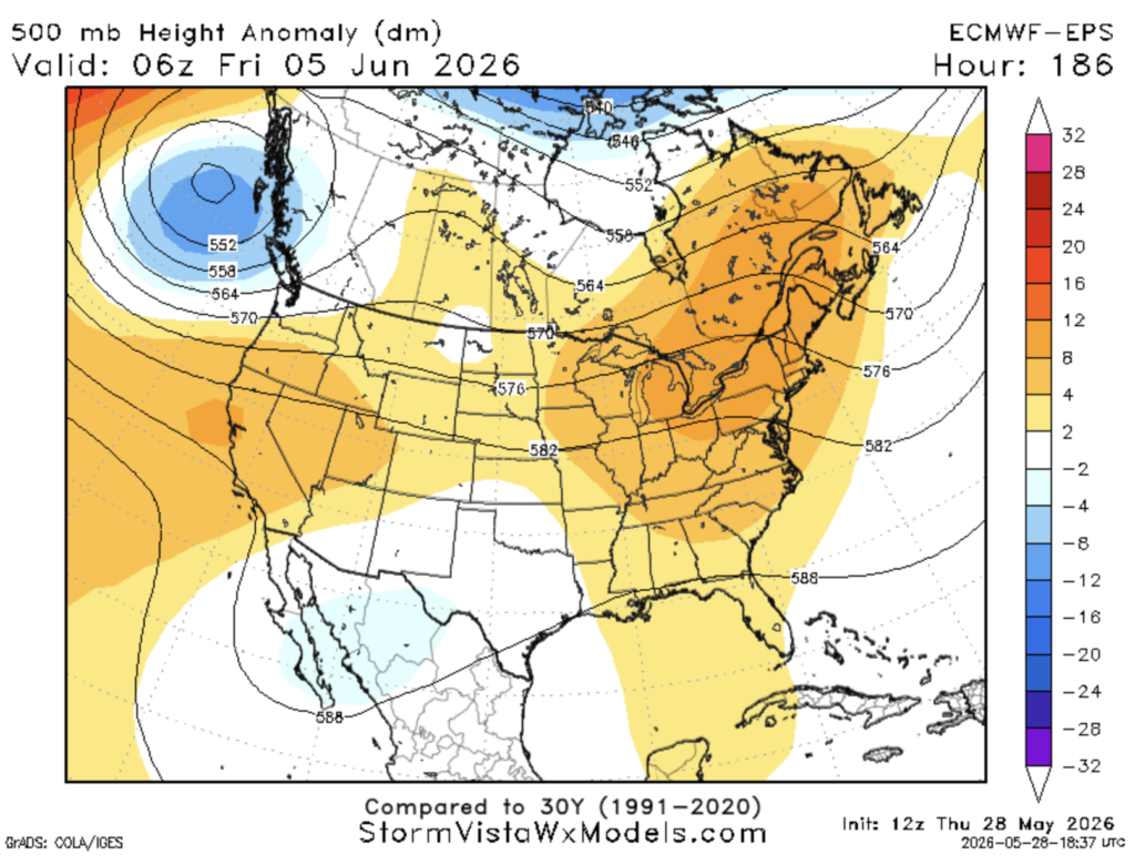
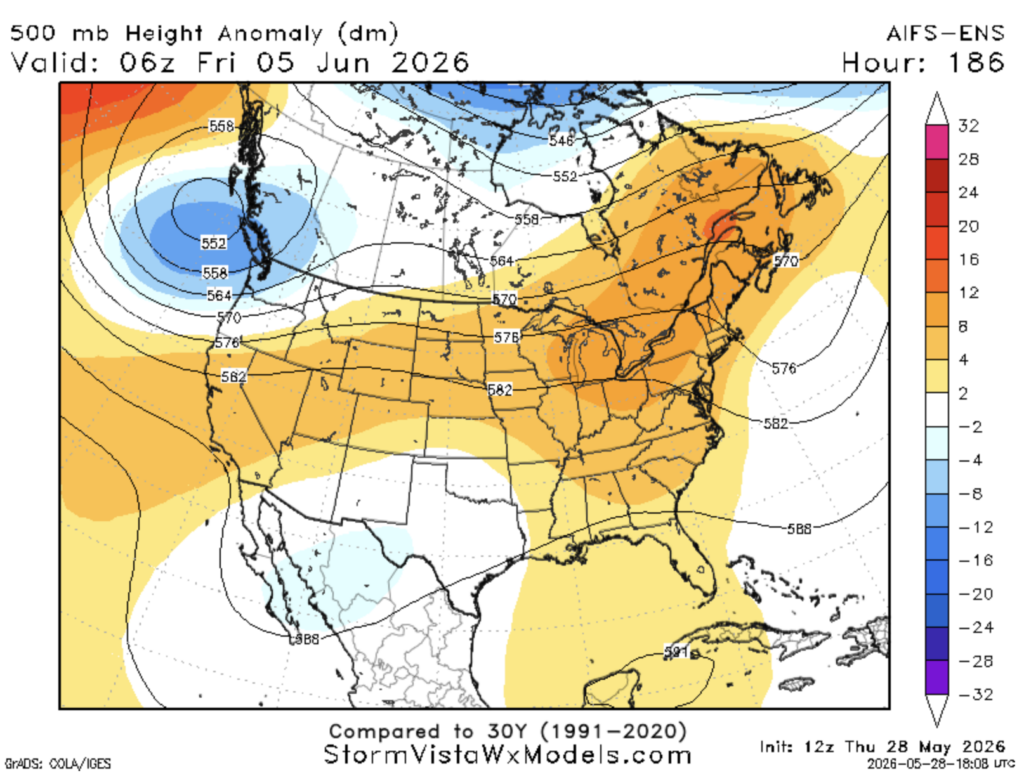
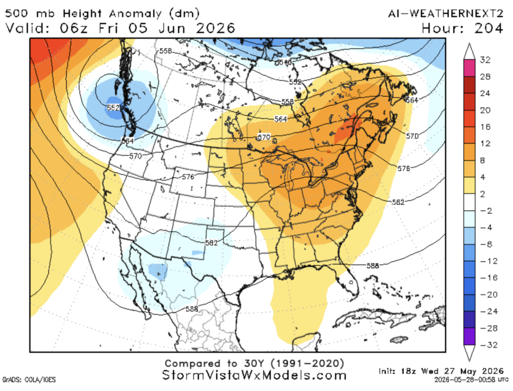
There are two other outcomes possible: Drier and warmer or humid and warmer.
Traveling Forecast
KHOU – Houston: Few clouds with highs in the upper 80s. Currently 82°. Winds are N 9 mph. Humidity is 60% with a dew point of 67°. Visibility is 10 miles. Clear with patchy fog tonight.
KSHV – Shreveport: Mostly cloudy with highs in the mid-80s. Currently 81°. Winds are NE 7 mph. Humidity is 70% with a dew point of 70°. Visibility is 10 miles. Slight chances for thunderstorms and showers tonight.
KBTR – Baton Rouge: Mostly cloudy with highs in the mid-80s. Currently 85°. Winds are S 13 mph. Humidity is 68% with a dew point of 73°. Visibility is 10 miles. Chance of showers tonight.
KMSY – New Orleans: Overcast with highs in the mid-80s. Currently 78°. Winds are E 7 mph. Humidity is 90% with a dew point of 75°. Visibility is 10 miles. Chances of thunderstorms and showers tonight.
KJAN – Jackson: Overcast with highs in the mid-80s. Currently 81°. Winds are E 9 mph. Humidity is 82% with a dew point of 75°. Visibility is 10 miles. Chances of thunderstorms and a slight chance of showers and patchy fog tonight.
KBHM – Birmingham: Overcast with highs in the mid-80s. Currently 85°. Winds are S 5 mph. Humidity is 63% with a dew point of 71°. Visibility is 10 miles. Chances of thunderstorms, showers, and patchy fog tonight.
KMOB – Mobile: Thunderstorm and light rain with highs in the mid-80s. Currently 81°. Winds are SE 12 mph. Humidity is 79% with a dew point of 74°. Visibility is 7 miles. Chances of showers and a slight chance of thunderstorms tonight.
KATL – Atlanta: Mostly cloudy with highs in the mid-80s. Currently 83°. Winds are N 9 mph. Humidity is 61% with a dew point of 68°. Visibility is 10 miles. Chances of thunderstorms and a slight chance of showers tonight.
KTLH – Tallahassee: Mostly cloudy with highs in the upper 80s. Currently 84°. Winds are NW 5 mph. Humidity is 67% with a dew point of 72°. Visibility is 10 miles. Chances of showers and patchy fog tonight.
I-10: Showers and thunderstorms stretching from MS to East FL. It will start to clear up around nighttime hours. Expect pop-ups near the LA/MS border during the late evening and Lake City to East FL toward the nighttime hours.
I-20: From the afternoon hours to late evening, thunderstorms and showers will push NE toward Central AL. Around 8 pm, it will start to clear up. Expect pop-ups near Central GA and the LA/MS border.
I-49: Pop-ups in LA till around the evening. Showers and possible thunderstorms in AR are scattered throughout the day into the nighttime hours.
I-55 and I-59: Scattered showers and thunderstorms near Central MS till the late evening. Pop-up showers and thunderstorms near South MS during the nighttime hours.
I-65: Showers and thunderstorms from South to Central AL into the late evening. Pop-up showers and thunderstorms toward the AL/TN border around the late evening till around 11 pm.
I-75: Scattered showers and thunderstorms in FL throughout the day into nighttime hours. Scattered showers in South GA around the late evening into nighttime hours. Pop-ups near Central GA during the late evening into early nighttime hours.
3 Day City Forecast
Houston, TX: Sunny with highs in the upper 80s. Mostly clear with patchy fog tonight into tomorrow morning. Lows in the mid-70s. Friday will be sunny with highs in the lower 90s. Partly cloudy with lows in the lower 70s Friday night. Saturday will be partly sunny with highs in the lower 90s. Mostly cloudy with lows in the mid 70s Saturday night. Calm winds the next three days.
Shreveport, LA: Mostly sunny with highs in the mid-80s. Partly cloudy with lows in the upper 60s and chance of showers and thunderstorms this afternoon into tonight. Friday will be mostly sunny with slight chances of showers and possible thunderstorms with highs in the lower 90s. Partly cloudy with slight chance of thunderstorms and showers Friday night into the early morning hours. Saturday will be mostly sunny with highs in the lower 90s. Slight chance of showers and thunderstorms in the afternoon. Mostly cloudy with lows in the mid 70s with a slight chance of showers and thunderstorms Saturday night. Calm winds the next three days.
Baton Rouge, LA: Mostly cloudy with highs in the lower 80s. Mostly cloudy with lows in the lower 70s and a chance of showers and thunderstorms this afternoon into tonight. Friday will be mostly sunny with chances of showers and thunderstorms with highs in the mid-80s. Partly cloudy with a chance of thunderstorms and showers until the late evening. Lows in the lower 70s Friday night. Saturday will be mostly sunny with highs in the upper 80s. Partly cloudy with lows in the lower 70s Saturday night. Calm winds the next three days.
New Orleans, LA: Mostly cloudy with highs in the lower 80s. Thunderstorms and showers until the early morning hours. Mostly cloudy with lows in the lower 70s tonight. Friday morning, there will be showers and thunderstorms with highs in the mid-80s. The afternoon will be partly sunny. Slight chance for showers and thunderstorms with lows in the mid 70s Friday night. Saturday will be mostly sunny with chances of showers and thunderstorms in the early evening, with highs in the upper 80s. Partly cloudy with lows in the mid 70s Saturday night. Relatively calm winds the next three days.
Jackson, MS: Mostly cloudy with chances of showers and thunderstorms. Highs in the mid-80s. Slight chances for showers and thunderstorms before the nighttime hours. After, mostly cloudy and patchy fog with lows in the lower 70s. Friday will be partly sunny with scattered showers throughout the day, with highs in the mid-80s. Lows will be in the upper 60s, and precipitation will continue Friday night. Saturday will be mostly sunny with chances of showers and thunderstorms after the morning hours. Highs in the upper 80s. Mostly cloudy with lows in the lower 70s Saturday night.
Birmingham, AL: Mostly cloudy with showers and thunderstorms likely during the evening. Highs in the mid-80s. Showers and storms will continue into the morning hours with lows in the upper 60s tonight. Friday will be highs in the lower 80s and lows in the upper 60s. Scattered showers and storms will continue all day. Saturday will have highs in the lower 80s with showers and possibly thunderstorms. Precipitation will dissipate throughout the night with lows in the upper 60s. Relatively calm winds the next three days.
Mobile, AL: Mostly cloudy with a chance of showers and thunderstorms. Highs in the mid-80s. Mostly cloudy with showers and thunderstorms, mostly in the early morning hours. Lows in the mid-70s tonight. Friday will be partly sunny with highs in the mid 80s. Scattered showers and thunderstorms until early evening. Mostly cloudy with lows in the mid 70s Friday night. Sunday will be mostly sunny with slight chances of showers and thunderstorms in the early morning hours. Highs in the upper 80s with chances of showers in the afternoon. Partly cloudy with lows in the mid-70s Saturday night. Relatively calm winds the next three days. Expect wind gusts.
Atlanta, GA: Partly sunny with chances of showers and thunderstorms. Highs in the mid-80s. Showers and thunderstorms continue into the morning with lows in the upper 60s. Mostly cloudy throughout tonight. Friday will be mostly cloudy with highs in the lower 80s. Chance of showers and thunderstorms into the evening. Scattered showers and thunderstorms will continue into the early morning hours. Lows in the mid-60s Friday night. Saturday will rainy with possible thunderstorms after the afternoon. Highs in the lower 80s. Expect showers and possible thunderstorms into the nighttime hours with lows in the mid-60s. Relatively calm winds the next three days. Expect wind gusts.
Tallahassee, FL: Mostly cloudy with chances of showers and thunderstorms. Highs in the mid 80s. Precipitation will continue mostly before the nighttime hours. Lows in the low 70s tonight. Friday will have highs in the upper 80s. Scattered showers and thunderstorms mainly during the early evening hours. Mostly cloudy with chances of showers and thunderstorms. Lows in the lower 70s tonight. Saturday will be rainy with thunderstorms all day. Highs in the upper 70s and lows in the lower 70s. Relatively calm winds the next three days.


