Good morning! If you’ve been following us for any amount of time, you won’t be surprised to learn that the upcoming forecast is not too different than what we’ve been seeing.
The Heat Advisory for portions of SW Mississippi has been Cancelled, but the NWS in Jackson still expects it to be hot. They have an area North of I-20 which could see heat indices around 105F, but lower for the rest of the region.

Instead of having yellows and oranges, we just have yellow on the map, indicating limited risk of high heat. This is in large part due to widespread cloud cover expected across the region this morning.
As we move closer to the afternoon, we will see some of the clouds break up, and thunderstorms are also expected to fire during the afternoon hours.

The HRRR shows scattered thunderstorms across our area forming around 1pm this afternoon, and continuing on for a couple of hours, dying down around sunset. Nothing too crazy, it’s pretty typical.
No severe weather is expected at this point, though individual storms can produce very isolated severe weather with little warning.

Looking at the upper level charts, a strong high pressure system continues to dominate this forecast area, with little chance for a disturbance or anything else to break our pattern.
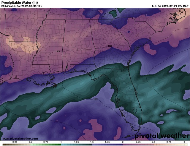
With the ridge located just to our North, we are set to see Easterly flow, making sure that the tropical air from the Atlantic continues to flow into the area. Moisture levels will remain high, so some of the storms over the next few days could produce heavy rain at times. Unsurprisingly, the PWAT values are still very high, over 2”.
This big high pressure is forecast to start breaking down over the next few days, and by Tuesday, guidance is suggesting a different look to the upper level wind fields.

The GFS is showing a trough over MS/AL/GA, which would bring stormy weather to the area in the beginning of next week. I increased storm chances for those days, since the storms are forecast to be more widespread and pretty commonplace around Southern MS.
With very high PWATs, and low shear, more heavy rain is certainly possible with this batch of thunderstorms. Really, any of these storms could produce heavy rainfall on any given day. The NWS Blend of models suggests that some areas may see up to 2” over the next 7 days, with the highest totals potentially East of McComb.
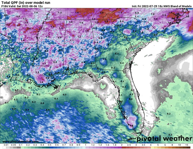
2 inches over 7 days isn’t really intense, so we probably aren’t looking at big flooding threats. Heavy rain could cause ponding on roadways but hopefully not much of a flash flooding threat.
The GFS shows a weakness in the ridge/some troughing from Tuesday into Thursday, which could give us a brief rest from the heat, and bring rainy and cooler weather before the ridge strengthens again Friday. “Cooler” doesn’t mean Fall temperatures,and we’re still forecast to hit 90F every day this next week, but just a tad under the average is possible. Heat Indices may not be quite as high as we’ve seen over the past couple of days.
Day-by-Day Forecast
Today
Mostly cloudy, with some peeks of sunshine this afternoon, with a 60-percent chance of afternoon thunderstorms. Highs in the low-90s. The heat index may reach 104F.
Tomorrow
Mostly sunny, with a 10-percent chance of a passing shower or storm. Highs in the mid-90s.
Monday
Partly cloudy, with a 40-percent chance of afternoon thunderstorms. Highs in the low-90s.
Tuesday
Partly cloudy, with a 50-percent chance of afternoon thunderstorms. Highs around 90F.
Wednesday
Mostly sunny, with a 50-percent chance of afternoon thunderstorms. Highs around 90F.
Thursday
Partly sunny, with a 40-percent chance of afternoon thunderstorms. Highs in the low-90s.
Friday
Mostly sunny, with a 20-percent chance of an afternoon storm. Highs in the mid-90s.


