The next few days have the potential for some rain as we start to warm up again in the southeast. Our temperatures will be rising later into next week and with that will come some dry weather after this weekend’s scattered showers. Let’s get into it!
[wpcode id=”41149″]
Scattered Showers Then Dry
Today we will see some scattered showers across the area especially in the coastal Mississippi and Alabama counties. Some of these showers will continue overnight and into tomorrow. Over the weekend spotty showers are possible with some scattered thunderstorms. Sunday night we will see thunderstorms across the coastal regions up to the central parts of MS and AL. Monday night into early Tuesday rain will be across the coast counties and eastern LA. After Tuesday we will enter a drier period for the next week with minimal rain across the region. Only the coast may see some slight rain later next week.
[wpcode id=”41149″]
Average Summer Heat
Temperatures are going to be feeling like summer for our area as we head into the middle of July. The highs will be hot but we will be slightly below average for our highs for the weekend. However that will pick right back up to hot early next week. We will become above average with some highs nearing or above 100. This heat is not as bad as it has been and definite feels more like a regular hot July.
[wpcode id=”41149″]
Extended Outlook
We can see this dry pattern continue for the next week and a half. With precipitation amounts low in our region. We even predict this dry pattern to last for the next two weeks or so. This amount of precipitation is slightly below normal for this time of year.
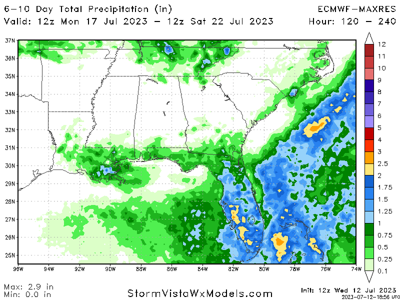
As for the warmer temperatures we will see above normal temperatures for our region within the next week to a week and a half. This pattern us due to ridging across the southwest and central region of the US.

[wpcode id=”41149″]
Regional Day-To-Day Forecast
Today: Partly cloudy. Chance of showers and thunderstorms. High temperatures in the low to mid 90s. Winds southwest 5 to 10 mph. Chance of rain 20%.
Tonight: Partly cloudy. Chance of showers and thunderstorms. Low temperatures in the upper 70s to low 80s. Winds southwest 5 to 10 mph. Chance of rain 20%.
Friday: Mostly cloudy. Chance of showers and thunderstorms. High temperatures in the low to mid 90s. Winds west 5 to 10 mph. Chance of rain 20%.
Friday Night: Partly cloudy. Low temperatures in the upper 70s to low 80s. Winds southwest 5 to 10 mph.
Saturday: Partly cloudy. High temperatures in the low to mid 90s. Winds southwest 5 to 10 mph. Chance of rain 30%.
Saturday Night: Partly cloudy. Low temperatures in the upper 70s to low 80s. Winds southwest 5 to 10 mph. Chance of rain 20%.
Sunday: Mostly sunny. Chance of showers and thunderstorms in the afternoon. High temperatures in the low to mid 90s. Winds west 5 to 10 mph. Chance of rain 60%.
Sunday Night: Mostly clear. Low temperatures in the upper 70s to low 80s. Winds south 5 to 10 mph. Chance of rain 20%.
Monday: Partly cloudy. Chance of showers and thunderstorms in the afternoon. High temperatures in the low to mid 90s. Winds west 5 to 10 mph. Chance of rain 50%.
Monday Night: Partly cloudy. Chance of showers and thunderstorms. Low temperatures in the upper 70s to low 80s. Winds southwest 5 to 10 mph. Chance of rain 20%.
Tuesday: Sunny. Chance of showers and thunderstorms. High temperatures in the mid to upper 90s. Winds west 5 to 10 mph. Chance of rain 20%.
Tuesday Night: Partly cloudy. Low temperatures in the upper 70s to low 80s. Winds southwest 5 to 10 mph.
Wednesday: Sunny. High temperatures in the mid to upper 90s. Winds southwest 5 to 10 mph. Chance of rain 10%.


