Howdy!
No rain in the region currently (around 12:30 CST), and little cloud coverage. A lot of sun for the region today, keeping conditions hot.
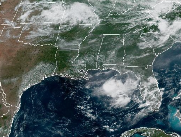
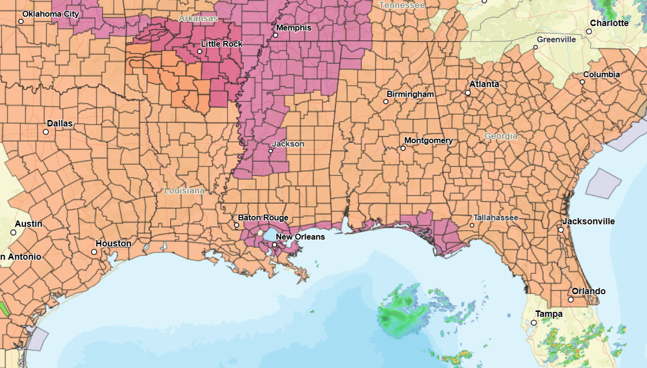
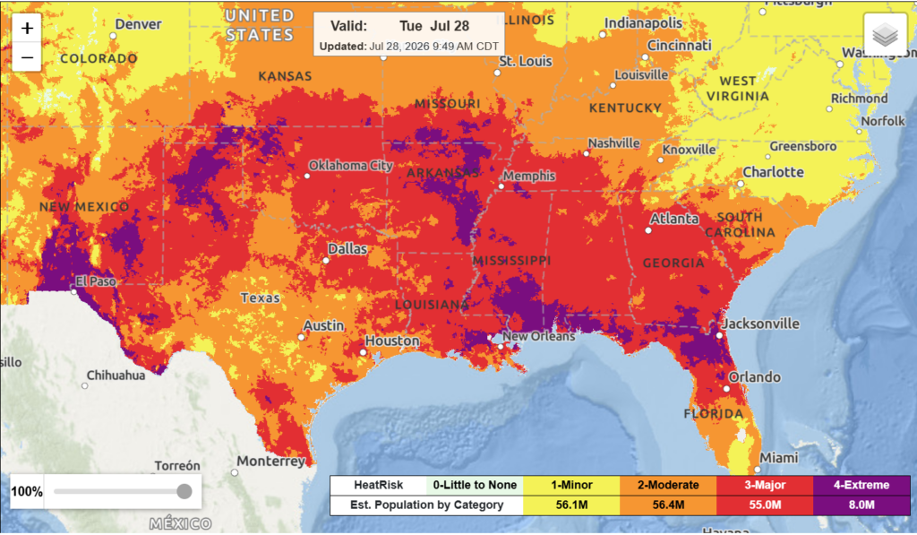
Highs will range in the 90 to as high as 101. Heat index values will reach well above 100, some areas already as high as 106. They could reach as high as 111-112 today, multiple heat advisories and extreme heat warnings are already in effect. Major to extreme heat risk is in effect for today. Stay hydrated and cool today!
Daily afternoon and evening showers will increase by the middle/later half of the week. A series of upper-level disturbances will move in along with a weak frontal boundary for the next couple of days, and by Friday a cold front will start to move in. This will keep conditions slightly cooler and will trigger showers and thunderstorms for the region.
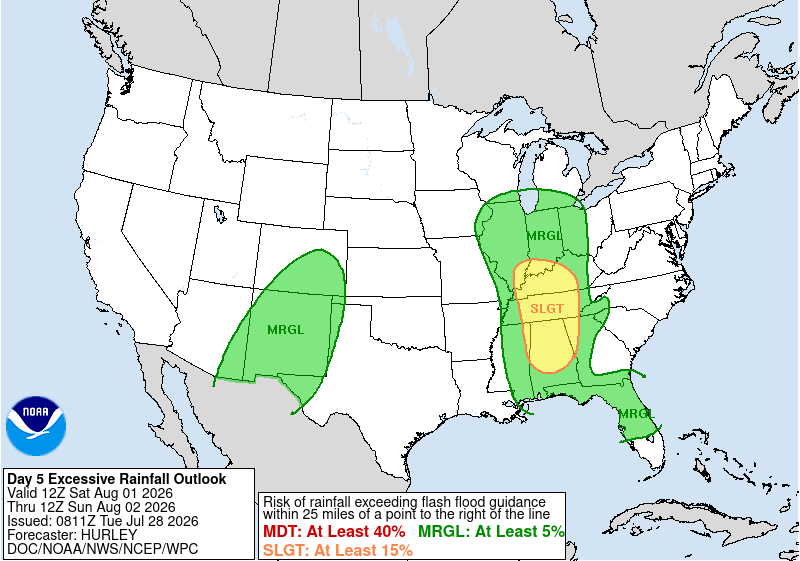
Excessive rainfall is possible for Saturday-Sunday for the region, main risk being in the central/northern parts of Alabama and a bit of Mississippi as well. Temperatures will be near normal for the next 6-10 days for a good part of the region, rainfall being a bit slightly above average for this time of year.
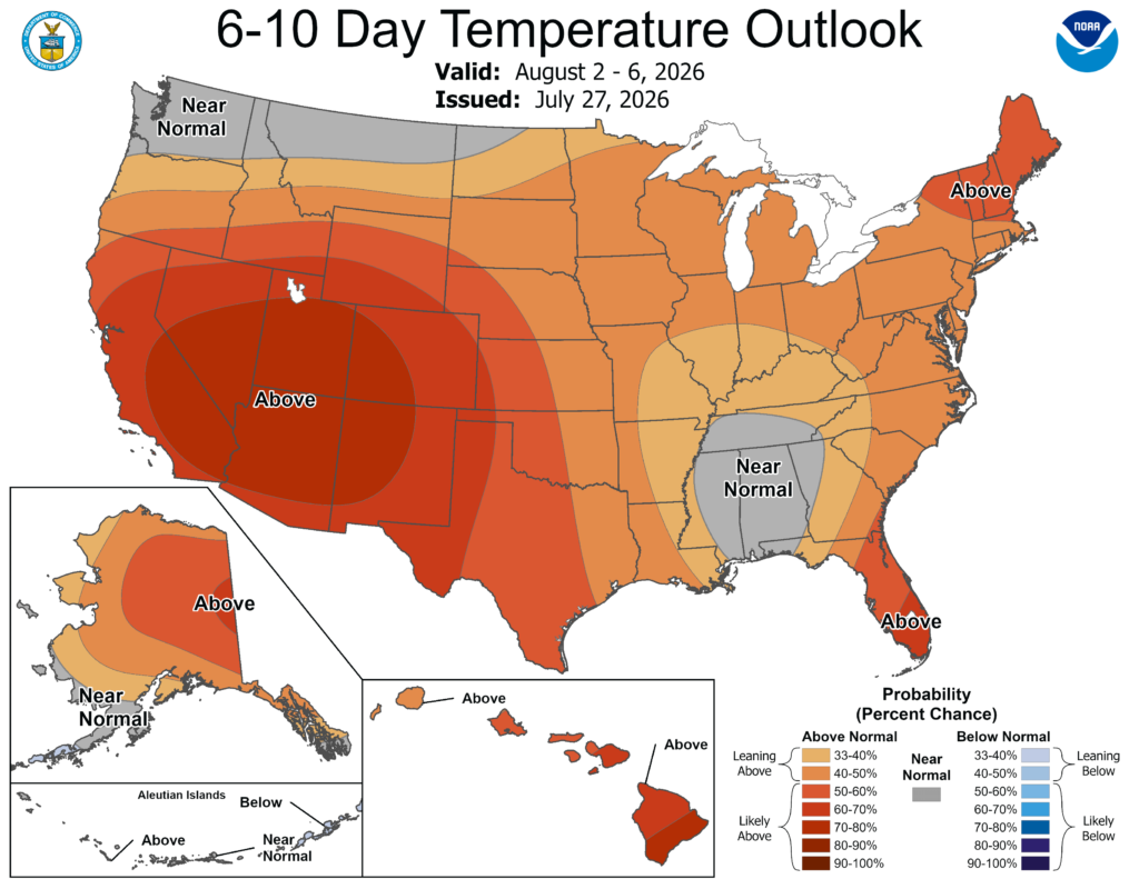
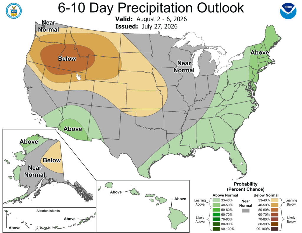
The troughing pattern will likely stick around into early next week, keeping temperatures near/below normal for this time of year. By the later half of next week, a return to ridging and a limited chance of rain will return.
3-DAY TRAVEL FORECAST
AIRPORTS
KIAH/KHOU (Houston) – No weather-related delays are anticipated.
KSHV (Shreveport) – No weather-related delays are anticipated. A slight chance for showers and thunderstorms exists Thursday afternoon, but not significant enough for any delays.
KBTR (Baton Rouge) – No weather-related delays are anticipated for today and tomorrow. Thursday afternooon and night, brief delays due to lightning are possible.
KJAN (Jackson) – No delays are expected today through tomorrow. Brief delays due to lightning are possible tomorrow night through Thursday.
KMSY (New Orleans) – No weather-related delays are anticipated today through tomorrow night. Brief delays due to lightning are possible Thursday afternoon/night.
KMOB (Mobile) – Brief delays due to lightning are possible each day as a chance of showers and thunderstorms exists each afternoon/night.
KATL (Atlanta) – No weather-related delays are anticipated.
KTLH (Tallahassee) – No weather-related delays are anticipated today. Brief delays due to lightning are possible tomorrow through Thursday night.
KBHM (Birmingham) – No weather-related delays are anticipated. A slight chance of thunderstorms exists tomorrow, but not significant enough for major delays.
HIGHWAYS
I-10 – Isolated showers and thunderstorms are possible each afternoon, the greatest chance of precipitation being Thursday morning/afternoon. It will be generally okay to travel for the next few days, but be careful of any storm that does occur.
I-20 – Isolated showers and thunderstorms are possible this afternoon. Scattered precipitation is possible tomorrow in the heat of the day. Thursday, showers and thunderstorms are likely thoughout the day, the morning starting in Louisiana. So, each day has a shot of precipitation, just be cautious of this.
I-49 – Today and tomorrow are generally good travel days with little to no precipitation, an isolated shower or thunderstorm possible. Greatest chance of showers and thunderstorms is Thursday throughout the entire day.
I-55 – Today looks like a good travel day, an isolated shower or thunderstorm possible. Tomorrow afternoon, northern/central Mississippi will see some showers and thunderstorms, and Thursday scattered precipitation will be possible.
I-59 – Today, not a great chance to see any rain. Tomorrow through Thursday, isolated to scattered showers and thunderstorms are possible along I-59, so be cautious of this.
I-65 – Showers and thunderstorms are possible each day, the greatest risk being tomorrow afternoon through Thursday.
I-75 – The greatest chance of showers and thunderstorms is tomorrow night through Thursday. Today will be a good travel day, an isolated chance of precipitation cannot be ruled out.
CITY FORECASTS
Houston, TX
Today/tonight – A heat advisory is in effect until 7:00pm tonight. It is going to be hot! The high will reach 100 with sunny conditions. Heat index values could reach as high as 109. Tonight, mostly clear and a low around 79.
Tomorrow – Another sunny and hot day with a high near 101 and heat index values reaching 109. Tomorrow night, mostly clear with a low around 80. Make sure to drink plenty of water!
Thursday – It will be mostly sunny and hot, a high near 102. Thursday night, partly cloudy skies and a low around 80. Again, another day to stay hydrated and cool.
Shreveport, LA
Today/tonight – A heat advisory is in effect until 8:00pm tonight. Sunny and hot, with a high near 98 and heat index values reaching as high as 106. Tonight, mostly clear with a low around 79.
Tomorrow – Another sunny and hot day with a high near 99 and heat index values as high as 108. Tomorrow night, mostly cloudy with a low around 79.
Thursday – A 20% chance of showers and thunderstorms in the afternoon. Other than that, partly sunny skies and hot conditions with a high near 96. Thursday night, partly cloudy conditions and a low around 78.
Baton Rouge, LA
Today/tonight – Sunny and hot conditions with a heat advisory in effect until 8:00pm. A high near 96 and heat index values as high as 105. Tonight, mostly clear with a low around 78.
Tomorrow – Sunny and hot conditions with a high near 97 and heat index values as high as 106. Tomorrow night, gradually building clouds overnight into the morning, with a low around 78.
Thursday – A 50% chance of showers and thunderstorms in the afternoon. Other than that, mostly sunny and hot with a high near 95. Thursday night, a 40% chance of showers and thunderstorms exists, the low around 77.
Jackson, MS
Today/tonight – An extreme heat warning is in effect today through 9:00pm tonight. Sunny and hot conditions with a high near 98 and heat index values as high as 110. Tonight, mostly clear with a low around 77.
Tomorrow – Mostly sunny conditions with a high near 97 and heat index values as high as 109. Tomorrow night, a 30% chance of showers and thunderstorms exists. Partly cloudy skies with a low aound 75.
Thursday – A 40% chance of showers and thunderstorms mainly after 10am. Mostly sunny with a high near 93. The low will fall around 73.
New Orleans, LA
Today/tonight – Sunny and hot conditions, an extreme heat warning is in effect until 8:00pm tonight. The high will be around 96 and heat index values as high as 107. Tonight, mostly clear with a low around 79.
Tomorrow – Sunny and hot conditions with a high near 97 and heat index values as high as 107. At night, partly cloudy skies and a low around 80.
Thursday – A 60% chance of showers and thunderstorms in the afternoon. Partly cloudy skies with a high around 93. Thursday night, a 40% chance of showers and thunderstorms exists with a low around 79.
Mobile, AL
Today/tonight – A heat advisory is in effect until 9:00pm tonight. Mostly sunny and hot with a high near 99. This afternoon, a 30% chance of showers and thunderstorms exists. Heat index values could reach as high as 111. Tonight, a 30% chance of showers and thunderstorms before 7pm, a low around 78.
Tomorrow – A 40% chance of showers and thunderstorms in the afternoon. Other than that, mostly sunny and hot conditions with a high near 98 and heat index values as high as 111. At night, a 50% chance of showers and thunderstorms, partly cloudy skies and a low around 76.
Thursday – A 60% chance of showers and thunderstorms in the afternoon. Mostly sunny and a high near 94. At night, a 40% chance of showers and thunderstorms with a low around 74.
Atlanta, GA
Today/tonight – A heat advisory is in effect until 8:00pm tonight. Sunny, with a high near 96 and heat index values as high as 103. Wind gusts up to 15 mph. Tonight, a slight chance of showers and thunderstorms exists. Partly cloudy skies with a low around 77.
Tomorrow – Partly sunny skies with a high near 91. Wind gusts up to 20mph are possible. Tomorrow night, mostly clear with a low around 70. Gusts up to 15 mph are possible.
Thursday – Sunny skies with a high near 90. Wind gusts up to 15 mph are possible. At night, mostly clear with a low around 69.
Tallahassee, FL
Today/tonight – A heat advisory is in effect until 8:00pm tonight. A 20% chance of showers and thunderstorms this afternoon. Mostly sunny and hot conditions with a high near 98 and heat index values as high as 107. Tonight, mostly clear with a low around 78.
Tomorrow – Mostly sunny and hot, then a 60% chance of showers and hunderstorms in the late afternoon. A high near 98 with heat index values as high as 111. Up to a quarter inch of rain is possible. Tomorrow night, a 60% chance of showers and thunderstorms exists and a low around 76.
Thursday – A 60% chance of showers and thunderstorms after 8am. Mostly sunny skeis with a high near 94. At night, a 60% chance of precipitation exists, with a low around 74.
Birmingham, AL
Today/tonight – A heat advisory is in effect until 9:00pm tonight. Sunny and hot conditions with a high near 98 and heat index values as high as 109. Tonight, partly cloudy skies with a low around 77.
Tomorrow – A 30% chance of showers and thunderstorms after 10am. Other than that, partly sunny with a high near 92. Tomorrow night, mostly clear with a low around 70.
Thursday – Sunny conditions with a high around 90. Thursday night, mostly clear skies and a low around 69.


