What a jump in the fall that we’ve had in the past week! Several cloudy days, rain, and temperatures staying under the 90s have been very welcome after the past few months of scorching heat.
With much of the rain that we’ve had in the past week, the fire weather hazards have diminished for most of the southern pine belt. However since we’re going back into another dry period for the next few days, some of those burn bans may come back into effect by midweek.
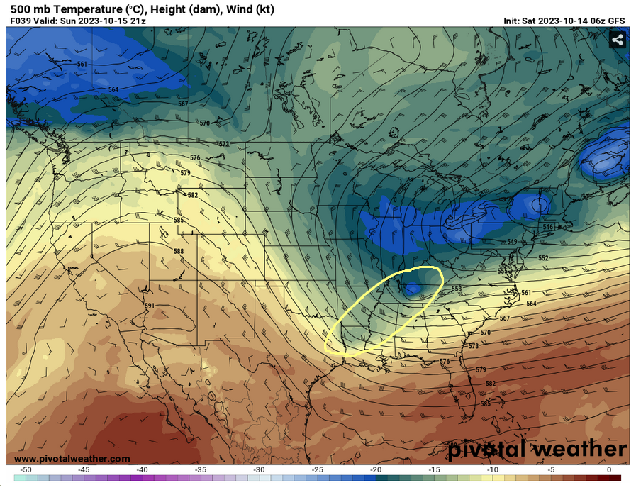
Looking at the 500mb map for this weekend, what’s called a “cold core” low pressure system will be moving in by Sunday. With this, it will bring in much cooler then average and blustery days to start off the week. Temperatures will reach the mid to upper 60s and dip down into the 40s at night.

Going towards the midweek, we’ll see another low pressure system that has developed from the Pacific Northwest and is moving through the Midwest to bring us another chance for rain. With the cold core low moving out at this point temperatures will stay around the 70s with dew points remaining around the 50s. So far the SPC is still waiting on the models to agree to find out if there’s any severe parameters with the system. Looking at both the GFS and the Euro model, both agree that there is a system that is going to move through the southeast, but they’re both mixed on where the rain will develop and how much rain is possible. Going by the max and minimums, it seems the range looks around 1/4 of an inch to about an inch. The system looks to develop overnight from Thursday into Friday.

Looking towards the weekend, we should have another dry spell with temperatures in the 70s and up into the 80s by Sunday. Skies should clear out and with the lower dew point, conditions should be fairly pleasant for the weekend.
[wpcode id=”41179″]
Regional Day-to-Day Forecast
Today – Sunny, with a high near 78. Northwest wind 5 to 10 mph, with gusts as high as 20 mph.
Tonight – Clear, with a low around 53. Northwest wind 5 to 10 mph.
Sunday – Mostly sunny, with a high near 68. North northwest wind 10 to 15 mph, with gusts as high as 25 mph.
Sunday Night – Mostly clear, with a low around 49. North northwest wind 10 to 15 mph, with gusts as high as 20 mph.
Monday – Sunny, with a high near 68. North northwest wind 10 to 15 mph, with gusts as high as 20 mph.
Monday Night – Clear, with a low around 44. North northwest wind 5 to 15 mph.
Tuesday – Sunny, with a high near 72. North northwest wind around 5 mph becoming northeast in the afternoon.
Tuesday Night – Clear, with a low around 45. Southeast wind around 5 mph becoming calm after midnight.
Wednesday – Sunny, with a high near 76. Light south southeast wind becoming south 5 to 10 mph in the morning.
Wednesday Night – Mostly clear, with a low around 51.
Thursday – Mostly sunny, with a high near 78.
Thursday Night – A 30 percent chance of showers. Partly cloudy, with a low around 57.
Friday – A 20 percent chance of showers. Mostly sunny, with a high near 75.
[wpcode id=”41149″]


