Based on some of the higher-resolution guidance, it appears as though the bullseye for the best chance for a brief wintry mix Wednesday has shifted slightly northward.
QUICK EXPLAINER
The brief shot will be between about 3am and 9am on Wednesday morning. And if you see anything at all, it will only last, intermittently, for about 15 to 20 minutes at a time.

So – and I want to be very transparent and honest here – the chance for meaningful “fun” snowfall is highly unlikely. I suppose not completely zero, but pretty close.
If I were to break it down numerically, the chance you see each type of preciptitation between 3a and 9a on Wednesday morning looks like this:
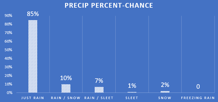
Not great odds for you snow-lovers out there.
SOME EXTRA DETAILS
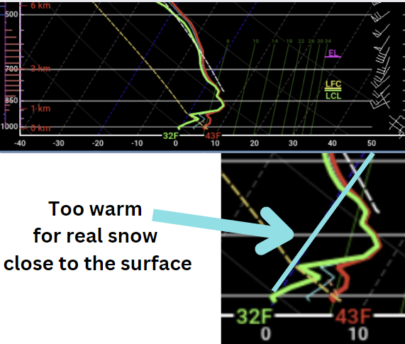
The problem we are running into (for you folks who want snow) is that we will be just a bit too warm (and fully saturated) from about 500ft above the surface through about 7,000ft above the surface. And that is a bit too far for snowflakes to travel and remain full snowflakes.
The reason I am leaving the door open for a mix is because we saturated the atmosphere pretty quickly around 3,000ft at temperatures above freezing, but the wet-blub temperature above and below that 3,000ft mark would allow for us to saturate the air and cool it down to near- or below-freezing.
On top of that, the atmosphere is pretty chilly – and unstable – above about 6,000ft. So we will be making snowflakes and making them quickly because the atmosphere is unstable.
So if the 3,000ft region of the atmosphere doesn’t saturate up as quickly as shown, we would (on paper) have a chance for some of those snowflakes to mix down to the surface in some of the heavier batches of precipitation given the temperature would be close to freezing through the column of air above the surface.
On Top of that, if we look at the Skew-T data for the rest of Wednesday (let’s pick Wednesday afternoon) we end up with an atmosphere that is pretty cold (and near freezing) about 500ft off the ground, briefly before warming back up. That means a rain/sleet mix is also possible briefly for some spots.
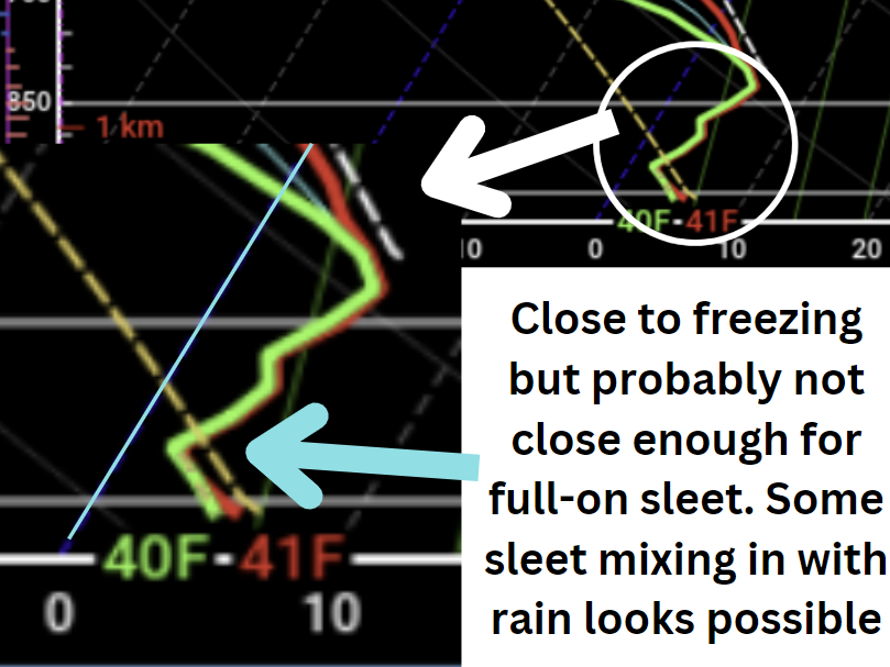
Fro that reason, we will hold onto a chance for a rain/sleet mix, too.
THE BOTTOM LINE
The chacne for full-on snow remains exceedingly small for folks on Wednesday morning. And the chance for full-on sleet Wednesday afternoon is equally as small.
But we could see one or both mix in with the rain at times. That means you may hear little plinks off your roof witht he rain or see some fatter raindrops or little snowflakes mix in with the rain on Wednesday – mainly in the morning.
I still don’t think we have to worry about any problems with businesses, schools, roads, or general daily activities. But it is a good reminder that for the next six weeks our atmosphere will be aligned to produce situations where wintry weather is more likely than typical for our area in winter.


WHY EVEN BOTHER TO SAY ANYTHING WHEN THERE IS A VERY SLIM CHANCE!!?
There are a ton of reasons! I like to keep everyone as informed as possible. There were other outlets suggesting full-on snow was possible at one point. The NWS is also highlighting the potential for a wintry mix now, too. Plus, I don’t want folks caught off-guard when/if there is some wintry precip.