With fairly cool conditions for our New Year’s Eve, we’ll break into the New Year with some rain spells for the next week.

Due to the cold front moving far south of our neck of the woods, the rain that I mentioned yesterday looks to stay mostly south into areas of South Louisiana and the Mississippi Gulf Coast. Most of this looks to be isolated to scattered and has less of a chance the further towards Hwy 84 that you go. This will likely exit by the early afternoon and bring in cool air to even out the temperatures. We will see temperatures in the mid 50s for Monday and Tuesday with conditions drying out after the rain is gone. At night, expect areas to frost as we dip into the upper 20s to low 30s.

Another Gulf low will reach much of the deep south with a few flurries mixed in, however, with lower atmosphere temperatures above the freezing mark and ground temperatures further from the freezing mark, there will likely be no accumulation. The other side of this is that there will be plenty of rain overnight to add to our totals for the month. Up to an inch of rain will be possible as we go throughout the day, and the rain may linger until the afternoon.
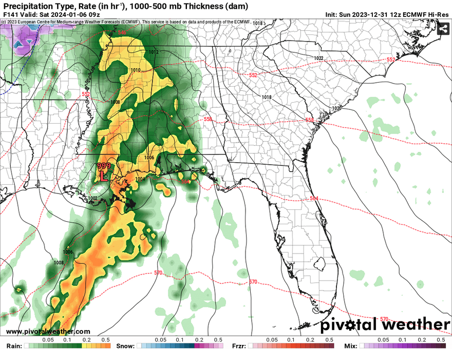
Thursday and Friday we’ll see fairly dry conditions and frosty mornings. Saturday is our next big chance of rain with another Gulf low setting up around us. Despite all the heavy rain on the image above, there aren’t many severe parameters to go along with it. Instability and dewpoints are very low which means that this is mainly a rain event. Some areas may see over an inch of rain while others may see up to three inches! Temperatures will stay around the 50s until the rain exits due east.
Have a Happy New Year!
[wpcode id=”41179″]
Regional Day-to-Day Forecast
This Afternoon – Mostly sunny, with a high in the low 60s. Southwest wind around 5 mph.
Tonight – Mostly cloudy during the early evening, then gradual clearing, with a low in the low 40s. South southwest wind around 5 mph becoming west northwest after midnight.
New Year’s Day – A slight chance of showers in the morning. Sunny, with a high in the upper 50s. North wind 5 to 10 mph. Chance of precipitation is 20%.
Monday Night – Areas of frost before midnight. Otherwise, clear, with a low in the upper 20s. North northeast wind around 5 mph.
TuesdayAreas of frost in the early morning. Otherwise, sunny, with a high in the mid 50s. East northeast wind around 5 mph.
Tuesday Night – A chance of showers overnight. Partly cloudy, with a low in the mid 30s. East wind around 5 mph. Chance of precipitation is 30%.
Wednesday – Showers until the afternoon. High in the upper 40s. East northeast wind 5 to 10 mph, with gusts as high as 20 mph. Chance of precipitation is 80%.
Wednesday Night – A slight chance of showers until midnight. Partly cloudy, with a low in the low 30s. North wind 5 to 10 mph, with gusts as high as 20 mph. Chance of precipitation is 20%.
Thursday – Sunny, with a high in the low 50s. North wind around 5 mph, with gusts as high as 20 mph.
Thursday Night – Areas of frost before midnight. Otherwise, clear, with a low in the upper 20s.
Friday – Areas of frost. Otherwise, sunny, with a high in the mid 50s.
Friday Night – Showers likely. Mostly cloudy, with a low in the mid 40s. Chance of precipitation is 70%.
Saturday – A 50 percent chance of showers. Mostly sunny, with a high in the mid 50s.
[wpcode id=”41149″]


